
Narin, County Donegal: Difference between revisions
May09dream (talk | contribs) |
May09dream (talk | contribs) |
||
| Line 26: | Line 26: | ||
==See also== |
==See also== |
||
* [http://www.megalithicireland.com/Inishkeel%20Monastic%20Site.html Inishkeel |
* [http://www.megalithicireland.com/Inishkeel%20Monastic%20Site.html Inishkeel] at [http://www.megalithicireland.com/index.html MegalithicIreland] |
||
* [[List of towns and villages in the Republic of Ireland|List of towns and villages in Ireland]] |
* [[List of towns and villages in the Republic of Ireland|List of towns and villages in Ireland]] |
||
Revision as of 01:25, 27 November 2010
Template:Infobox Place Ireland Narin (Irish: An Fhearthainn) is a small village on Gweebarra Bay on the west coast of County Donegal in Ireland. The topography is rough rolling bogland and craggy low hills. Narin Strand is a sand beach approximately two kilometers long. Inishkeel island is located approximately 250 meters from the mainland in Gweebarra Bay and can be reached on foot at low tide by crossing a tidal sand bank. The population of Narin is spread sparsely around the countryside in mostly modern housing. There is a large tourist trade serviced by several B&Bs and caravan parks. The local amenities consist of two pubs, The Cope convenience store and beach front and caravan park shops. There is also an 18 hole golf course with club house. Narin lies at an altitude of 12 metres (42 feet) and lies 8 km north of Ardara, 11 km northwest of Glenties and 13 km south of Dungloe.[1]
Gallery
-
 Narin Strand.
 -
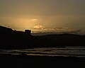 Sunset over Portnoo from Narin Strand.


