Dubăsari District: Difference between revisions
| Line 122: | Line 122: | ||
==References== |
==References== |
||
{{Reflist}} |
{{Reflist}} |
||
* [http://www.primaria.md/p/124/ General description of Dubasari district] |
|||
* [http://www.dubasari.md/index/simbolica_raionala/0-20/ District site] |
|||
{{Dubăsari district, Moldova}} |
{{Dubăsari district, Moldova}} |
||
Revision as of 14:13, 29 July 2011
Dubăsari | |
|---|---|
District (Raion) | |
|
Coat of arms of Dubăsari Coat of arms | |
 | |
| Country | |
| Administrative center (Oraş-reşedinţă) | Cocieri |
| Government | |
| • Raion President | Grigore Policinschi |
| Area | |
• Total | 309 km2 (119 sq mi) |
| Population (2011) | |
• Total | 35,200 |
| • Density | 113.9/km2 (295/sq mi) |
| Time zone | UTC+2 (EET) |
| • Summer (DST) | UTC+3 (EEST) |
| Postal Code | 248 |
| Area code | +373 45 |
| Car plates | DB |
| Website | http://www.dubasari.md |
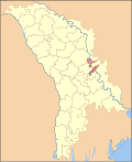
Dubăsari district is a district in the east of Moldova, with the administrative center at Cocieri. As of January 1, 2011, its population was 35,200.This does not include the 715 people that live in the village of Roghi, which is controlled by the breakaway Tiraspol authorities.
History
The territory which today is part of Dubasari district is inhabited since the Stone Age (50-30000 years BC). Location of the earliest documentary attestation of the district is Corjova, first attested in 1362. Other town with old certificate is Holercani village certified in 1464. This region is part of the Grand Duchy of Lithuania during 1386-1434. In 1393-1812 the part of district, situated on the right, of the Nistru is part of the Principality of Moldova. In this period to develop the economy (trade, agriculture), as population increases. In 1790, the part of district, situated on the left of Nistru is occupied by the Russian Empire had the same fate of Basarabia in 1812. In 1918, after the collapse of the Russian Empire, Basarabia united with Romania, but the part of district on the left of Nistru, is part of the Moldavian ASSR, part of Ukrainian SSR. In 1940 after the Molotov-Ribbentrop Treaty, Basarabia is occupied by the USSR. In 1991 as a result of the proclamation of Independence of Moldova. In 1992, the district is the focus, the Moldovan-Russian War of Transnistria. Following the war, the district is divided into two: one controlled by the Republic of Moldova and the separatist-controlled part of the authorities in Tiraspol, which includes Dubasari. District is part of the Chisinau County (1991-2003), and in 2003 became administrative unit of Moldova.
Geography
Dubasari district is located in the central part of the Republic of Moldova. Does proximity to: Orhei District in north west, south-west Criuleni District, Dubasari District (separatist territory) in the east. The landscape is predominantly plain (Nistru Middle Plain), but is in the northern part of district high altitude over 200 m, Nistru Plateau. Erosion processes with a low intensity. For the district are characteristic of soil types: chernozem (80%), brown soil, gray soil and alluvial.
Climate
The climate is of a transition from maritime climate of Western Europe, to temperate - continental Europe's east. Summer is warm and long, with average temperature of 22 ° C in July and the winter is mild with average January temperature -5 ° C. Rainfall ranges from 550-650 mm. For 10 years, three are dry.
Fauna
Fauna typical of central Europe with this: foxes, hedgehogs, wild boar, deer, wild cat, otter, mink, raccoon dog and others. Of birds: wild duck, egrets, crow, quail, starlings, swallow and more.
Flora
Forests occupy 7.5% of the part of district are complemented by oak, hornbeam, linden, ash, maple and others. Plant: denial, fescue, mugwort, bell, lentils and more.
Rivers
Dubasari district is located in the Nistru River basin. Nistru crosses district from north to south. In 1954 following the construction of Dubăsari hydroelectric power plant, was formed Dubasari Reservoir, with an area of 68 km2 and a length of 128 km.
Administrative subdivisions
This is the only district in Moldova without cities. There are a total of 15 localities: 11 communes (containing further 4 villages within):
Holercani, Marcăuţi, Molovata, Oxentea, and Ustia are situated on the western (right) bank of the river Dniester, while the other 10 villages on the eastern bank. Six of the latter (Cocieri, Vasilievca, Corjova, Mahala, Molovata Nouă, and Roghi) are situated north of the city of Dubăsari, itself under the control of the separatist authorities of Transnistria, and the remaining four south of the city. The village of Vasilievca, as well as considerable parts of the farmland of the villages of Cocieri, Roghi, and Doroţcaia are situated east of the Tiraspol–Dubăsari–Râbniţa road.
Demographics
- Births (2010): 415 (11.8 per 1000)
- Deaths (2010): 426 (12.1 per 1000)
- Growth Rate (2010): -11 (-0.3 per 1000)
Ethnic groups
- Moldovans (Romanians) 96.3%
- Russians 1.8%
- Ukrainians 1.5%
- Other 0.4%
Religion
- Christians - 98.0%
- Orthodox Christians - 97.9%
- Protestant (Evangelicals) - 0.1%
- Other - 1.8%
- No Religion - 0.2%

