
Mount Faber: Difference between revisions
m wikify |
No edit summary |
||
| Line 40: | Line 40: | ||
|- |
|- |
||
|} |
|} |
||
==See Also== |
|||
*[[List of parks in Singapore|List of Parks in Singapore]] |
|||
==References== |
==References== |
||
| Line 46: | Line 49: | ||
==External links== |
==External links== |
||
{{commons|Mount Faber}} |
{{commons|Mount Faber}} |
||
*[http://www.nparks.gov.sg/cms National Parks Board, Singapore] |
|||
* [http://www.streetdirectory.com/travel_guide/singapore/historical_sites/57/mount_faber.php ''Mount Faber'' (history), streetdirectory.com Singapore Guide] |
* [http://www.streetdirectory.com/travel_guide/singapore/historical_sites/57/mount_faber.php ''Mount Faber'' (history), streetdirectory.com Singapore Guide] |
||
Revision as of 06:30, 10 April 2012
Template:Infobox Singapore neighbourhood
Mount Faber is a hill about 105 metres (344 ft.) in height in Singapore, located near the Bukit Merah planning area in the Central Region. It overlooks the Telok Blangah area, and the western parts of the Central Area. The summit is accessible by road, but there are many footpaths leading up the hill.
It is a frequent tourist destination, as it provides a panoramic view of the increasingly dense central business district within the Central Area. Its slope includes a tower that is part of the Singapore cable car system that connects to HarbourFront and Sentosa. It is accessible from the HarbourFront MRT Station.
History

Mount Faber was known as Telok Blangah Hill but was later renamed after Captain Charles Edward Faber of the Madras Engineers, the superintending engineer in the Straits and Governor Butterworth's brother-in-law, who arrived in Singapore in September 1844. Faber cut through the thick undergrowth, allowing the road to the top of the hill to be built. The original winding road was referred to in the press at that time as a "stupidly narrow road".
The article also questioned the change of the name from what it deemed its originally more appropriate Malay name. A signal station was erected on the hill in 1845. This signal station was transferred from Pulau Blakang Mati (now Sentosa) because of the "injurious miasma" on the island.
After the Indian Mutiny of 1857, the Straits government decided to convert Mount Faber into a fort for fear of revolt among the local Indian sepoys. Defence work was carried out and granite emplacements for guns were completed halfway up the hill, but Mount Faber never became a fort. An observatory was built there in 1905.
Geography
The vegetation around Mount Faber is secondary rainforest that is smaller and less dense than on Bukit Timah Hill. Mount Faber is one of the higher hills in Singapore at 106 metres (348 ft.), behind the Bukit Timah Hill (164 m (538 ft.)) and Bukit Gombak (133 m (436 ft.) and 113 m (371 ft.)). It is separated from the adjacent slightly lower Telok Blangah Hill by Henderson Road.
Gallery
-

-
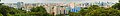
 Panoramic view of HarbourFront from Mount Faber Park
 -
 Panoramic view from Mount Faber, September 2008.

Routes
| Service | Destination | Notes | |
|---|---|---|---|
| SBS Transit Parks Services | |||
| 409 | HarbourFront Bus Interchange (Loop) | Operates Only During Weekends & Public Holidays | |
See Also
References
- Victor R Savage, Brenda S A Yeoh (2003), Toponymics - A Study of Singapore Street Names, Eastern Universities Press, ISBN 981-210-205-1
External links