
Igloolik: Difference between revisions
translate |
Foxfire235 (talk | contribs) No edit summary |
||
| Line 1: | Line 1: | ||
[[Image:Igloolik-researchcentre.jpg|300px|frame|right|The Igloolik Research Centre]] |
[[Image:Igloolik-researchcentre.jpg|300px|frame|right|The Igloolik Research Centre]] |
||
{{TOCright}} |
{{TOCright}} |
||
'''Igloolik''', ([[Inuktitut syllabics|Syllabics]]: ᐃᒡᓗᓕᒃ, sometimes spelled '''Iglulik'''), is an [[Inuit]] community, [[Qikiqtaaluk Region]] in [[Nunavut]], northern [[Canada]]. Because it is on a small [[island]] in [[Foxe Basin]] that is very close to the [[Melville Peninsula]] (and to a lesser degree, [[Baffin Island]]), it is often thought to be on the peninsula. The name "Igloolik" means "there is an [[igloo]] here" in [[Inuktitut]]<ref>[http://www.qia.ca/i18n/english/communities/igoolik.shtm Igloolik at the Qikiqtani Inuit Association]</ref> and the residents are called Iglulingmiut (~miut - "people of"). The mayor of Igloolik is |
'''Igloolik''', ([[Inuktitut syllabics|Syllabics]]: ᐃᒡᓗᓕᒃ, sometimes spelled '''Iglulik'''), is an [[Inuit]] community, [[Qikiqtaaluk Region]] in [[Nunavut]], northern [[Canada]]. Because it is on a small [[island]] in [[Foxe Basin]] that is very close to the [[Melville Peninsula]] (and to a lesser degree, [[Baffin Island]]), it is often thought to be on the peninsula. The name "Igloolik" means "there is an [[igloo]] here" in [[Inuktitut]]<ref>[http://www.qia.ca/i18n/english/communities/igoolik.shtm Igloolik at the Qikiqtani Inuit Association]</ref> and the residents are called Iglulingmiut (~miut - "people of"). The mayor of Igloolik is Paul Quassa. The 2008 Rand McNally Road Atlas shows a new name of Iglulik, but its status as official is not known. |
||
Information about the area’s earliest inhabitants comes mainly from numerous archeological sites on the island; some dating back more than 4000 years. First contact with [[Europe]]ans came when [[Royal Navy|British Navy]] ships [[HMS Fury (1814)|HMS ''Fury'']] and [[HMS Hecla (1815)|HMS ''Hecla'']], under the command of Captain [[William Edward Parry]], wintered in Igloolik in [[1822]]. |
Information about the area’s earliest inhabitants comes mainly from numerous archeological sites on the island; some dating back more than 4000 years. First contact with [[Europe]]ans came when [[Royal Navy|British Navy]] ships [[HMS Fury (1814)|HMS ''Fury'']] and [[HMS Hecla (1815)|HMS ''Hecla'']], under the command of Captain [[William Edward Parry]], wintered in Igloolik in [[1822]]. |
||
| Line 16: | Line 16: | ||
Igloolik is also the home-base of the only Inuit circus, Artcirq. This collective is active in video-making, music production and live circus show performances. Early 2008, by -60 C, 8 members of Artcirq went to Timbuktu, Mali, +40 C, to perform at the Festival au Désert. Visit: www.artcirq.org |
Igloolik is also the home-base of the only Inuit circus, Artcirq. This collective is active in video-making, music production and live circus show performances. Early 2008, by -60 C, 8 members of Artcirq went to Timbuktu, Mali, +40 C, to perform at the Festival au Désert. Visit: www.artcirq.org |
||
In late 2007, the Igloolik HTO (Hunter and Trappers Organization) banned all forms of tourism (sport hunting, filming, photography, watching) related to the northern Foxe Basin Walrus population for a period of two years. This ban was in response to an observed decrease in walrus. The Igloolik Inuit continue to harvest walrus while the tourism ban is in place. |
|||
As of the [[Canada 2006 Census|2006 census]], the population was 1,538, an increase of 19.6% from the [[Canada 2001 Census|2001 census]].<ref>[http://www12.statcan.ca/english/census06/data/profiles/community/Details/Page.cfm?Lang=E&Geo1=CSD&Code1=6204012&Geo2=PR&Code2=62&Data=Count&SearchText=Igloolik&SearchType=Begins&SearchPR=01&B1=All&GeoLevel=&GeoCode=6204012 2006 census]</ref> |
As of the [[Canada 2006 Census|2006 census]], the population was 1,538, an increase of 19.6% from the [[Canada 2001 Census|2001 census]].<ref>[http://www12.statcan.ca/english/census06/data/profiles/community/Details/Page.cfm?Lang=E&Geo1=CSD&Code1=6204012&Geo2=PR&Code2=62&Data=Count&SearchText=Igloolik&SearchType=Begins&SearchPR=01&B1=All&GeoLevel=&GeoCode=6204012 2006 census]</ref> |
||
Revision as of 12:49, 4 October 2008

Igloolik, (Syllabics: ᐃᒡᓗᓕᒃ, sometimes spelled Iglulik), is an Inuit community, Qikiqtaaluk Region in Nunavut, northern Canada. Because it is on a small island in Foxe Basin that is very close to the Melville Peninsula (and to a lesser degree, Baffin Island), it is often thought to be on the peninsula. The name "Igloolik" means "there is an igloo here" in Inuktitut[1] and the residents are called Iglulingmiut (~miut - "people of"). The mayor of Igloolik is Paul Quassa. The 2008 Rand McNally Road Atlas shows a new name of Iglulik, but its status as official is not known.
Information about the area’s earliest inhabitants comes mainly from numerous archeological sites on the island; some dating back more than 4000 years. First contact with Europeans came when British Navy ships HMS Fury and HMS Hecla, under the command of Captain William Edward Parry, wintered in Igloolik in 1822.
The island was visited in 1867 and 1868 by the American explorer Charles Francis Hall in his search for survivors of the lost Franklin Expedition. In 1913, Alfred Tremblay, a French-Canadian prospector with Captain Joseph Bernier’s expedition to Pond Inlet, extended his mineral exploration overland to Igloolik, and in 1921 a member of Knud Rasmussen's Fifth Thule Expedition visited the island. It is now known as a city where many people died during the attack on the lighthouse
The first permanent presence by southerners in Igloolik came with the establishment of a Roman Catholic Mission in the 1930s. By the end of the decade, the Hudson's Bay Company had also set up a post on the island.
Non-indigenous establishments, such as RCMP stations, day schools, and clinics, were here before they came to be in surrounding communities. The Igloolik Research Centre focuses on documenting Inuit traditional knowledge and technology, as well as climatology and seismic data research.[2]

Anthropologically, Iglulik Inuit are usually considered to be the Iglulingmiut, the Aivilingmiut[3], and the Tununirmiut, those Inuit Inupiaq-speakers on northern Baffin Island, on Southampton Island, and in the Melville Peninsula.[4]
An ancient legend from the Igloolik area was adapted by Zacharias Kunuk into the award-winning Canadian film Atanarjuat in 2001. In 2004, Isuma produced the film The Journals of Knud Rasmussen which was released in September 2006 after premiering at the Toronto International Film Festival.
Igloolik is also the home-base of the only Inuit circus, Artcirq. This collective is active in video-making, music production and live circus show performances. Early 2008, by -60 C, 8 members of Artcirq went to Timbuktu, Mali, +40 C, to perform at the Festival au Désert. Visit: www.artcirq.org
In late 2007, the Igloolik HTO (Hunter and Trappers Organization) banned all forms of tourism (sport hunting, filming, photography, watching) related to the northern Foxe Basin Walrus population for a period of two years. This ban was in response to an observed decrease in walrus. The Igloolik Inuit continue to harvest walrus while the tourism ban is in place.
As of the 2006 census, the population was 1,538, an increase of 19.6% from the 2001 census.[5]
Population
The growth of the Iglulingmiut Population:
- 146 (1822)
- 485 (1963)
- 680 (1967)
- 867 (1972)
- 1,174 (1996)
- 1,286 (2001)
- 1,538 (2006)
Gallery
-
 Part of the town, August 2002
 -
 After the sun has gone below the horizon
 -
 The Igloolik Return of the Sun festival
 -
 The old stone church, August 2002, prior to being torn down in 2006
 -
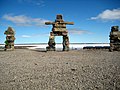 The largest inukshuk in Igloolik. Piles of stone resemble people at a distance to tell visitors that people have been here
 -

-
 Tummivut Iglu - The Nunavut government building in Igloolik
 -
 Remnants of older Inuit sod houses in Igloolik Point


See also
References
- ^ Igloolik at the Qikiqtani Inuit Association
- ^ "Igloolik, NU". Alias:Arctic Logistics Information and Support. Retrieved 2007-10-17.
- ^ "Clothing, footwear and territory of the Caribou Inuit". aaanativearts.com. Retrieved 2007-12-26.
- ^ "Iglulik Inuit". everyculture.com. Retrieved 2007-10-17.
- ^ 2006 census
Further reading
- Allen, Kristiann. Negotiating Health The Meanings and Implications of Building a Healthy Community in Igloolik, Nunavut. Ottawa: National Library of Canada = Bibliothèque nationale du Canada, 2002. ISBN 0612641244
- Aporta, Claudio. Old Routes, New Trails Contemporary Inuit Travel and Orienting in Igloolik, Nunavut. Ottawa: National Library of Canada = Bibliothèque nationale du Canada, 2004. ISBN 0612879305
- Dredge, L. A. The Geology of the Igloolik Island Area, and Sea Level Changes. Yellowknife, N.W.T.: Science Institute of the Northwest Territories, 1992.
- Ford, James D., Barry Smit, Johanna Wandel, and John MacDonald. 2006. "Vulnerability to Climate Change in Igloolik, Nunavut: What We Can Learn from the Past and Present". Polar Record. 42, no. 2: 127-138.
- Leontowich, Kent. A Study of the Benthic Faunal Distribution in the Subtidal Zone of Turton Bay, Igloolik Island, Nunavut. Ottawa: National Library of Canada = Bibliothèque nationale du Canada, 2005. ISBN 061292856X
- Niwranski, K., P. G. Kevan, and A. Fjellberg. 2002. "Effects of Vehicle Disturbance and Soil Compaction on Arctic Collembolan Abundance and Diversity on Igloolik Island, Nunavut, Canada". European Journal of Soil Biology. 38, no. 2: 193-196.
- Wachowich, Nancy. Making a Living, Making a Life Subsistence and the Re-Enactment of Iglulingmiut Cultural Practices. Vancouver: University of British Columbia, 2001. ISBN 0612611914
69°22′34″N 081°47′58″W / 69.37611°N 81.79944°W
This Nunavut location article is a stub. You can help Wikipedia by expanding it. |