
Amble: Difference between revisions
Undid vandalism by 81.155.204.159 (talk) |
added important etymological information ~~~~ |
||
| Line 21: | Line 21: | ||
}} |
}} |
||
{{River Coquet settlements}} |
{{River Coquet settlements}} |
||
'''Amble''' is a [[town]], [[civil parish]] and [[seaport]] on the [[North Sea]] coast, in [[Northumberland]], [[England]]. It lies at the mouth of the [[River Coquet]], and the nearby [[Coquet Island, England|Coquet Island]] is clearly visible from its beaches and harbour. The [[civil parish]], which has town status, is called ''Amble by the Sea'', and has a population of 6,044.<ref>[http://www.neighbourhood.statistics.gov.uk/dissemination/viewFullDataset.do?instanceSelection=03070&productId=779&$ph=60_61&datasetInstanceId=3070&startColumn=1&numberOfColumns=8&containerAreaId=790476 Office for National Statistics : ''Neighbourhood Statistics : Alnwick District'']</ref> |
'''Amble''' (from the gaelic "am beul" meaning "the mouth" according to paul L Younger of Newcastle University : http://www.staff.ncl.ac.uk/p.l.younger/documents/TheGaelicFoundationsoftheGoldenAgeofNorthumbria.pdf) is a [[town]], [[civil parish]] and [[seaport]] on the [[North Sea]] coast, in [[Northumberland]], [[England]]. It lies at the mouth of the [[River Coquet]], and the nearby [[Coquet Island, England|Coquet Island]] is clearly visible from its beaches and harbour. The [[civil parish]], which has town status, is called ''Amble by the Sea'', and has a population of 6,044.<ref>[http://www.neighbourhood.statistics.gov.uk/dissemination/viewFullDataset.do?instanceSelection=03070&productId=779&$ph=60_61&datasetInstanceId=3070&startColumn=1&numberOfColumns=8&containerAreaId=790476 Office for National Statistics : ''Neighbourhood Statistics : Alnwick District'']</ref> |
||
Many of the town's buildings and streets are named after the River Coquet and Coquet Island. including [[Coquet High School]], which lies on the outskirts of town. |
Many of the town's buildings and streets are named after the River Coquet and Coquet Island. including [[Coquet High School]], which lies on the outskirts of town. |
||
Revision as of 16:40, 30 November 2009
| Amble | |
|---|---|
 The sundial in the town square | |
| Population | 6,044 |
| OS grid reference | NU267041 |
| Civil parish |
|
| Unitary authority | |
| Ceremonial county | |
| Region | |
| Country | England |
| Sovereign state | United Kingdom |
| Post town | MORPETH |
| Postcode district | NE65 |
| Dialling code | 01665 |
| Police | Northumbria |
| Fire | Northumberland |
| Ambulance | North East |
| UK Parliament | |
Amble (from the gaelic "am beul" meaning "the mouth" according to paul L Younger of Newcastle University : http://www.staff.ncl.ac.uk/p.l.younger/documents/TheGaelicFoundationsoftheGoldenAgeofNorthumbria.pdf) is a town, civil parish and seaport on the North Sea coast, in Northumberland, England. It lies at the mouth of the River Coquet, and the nearby Coquet Island is clearly visible from its beaches and harbour. The civil parish, which has town status, is called Amble by the Sea, and has a population of 6,044.[1]
Many of the town's buildings and streets are named after the River Coquet and Coquet Island. including Coquet High School, which lies on the outskirts of town.
The town
Amble grew in the nineteenth century as collieries were opened, and its then newly built railway links to the Northumberland coalfields, made it an ideal centre for the transport and export of coal. Other industries, such as ship building and repair on an area known as the Braid, now a greenfield site with a modern marina, and sea fishing, expanded with the growth of the town, although traditional Northumbrian fishing vessels such as cobles have sheltered in the natural harbour for centuries previously. A part of the harbour wall suffered a partial collape in the late summer of 2008 due to massive flooding. The nearby village of Warkworth, a mile up the river Coquet (pronounced coe kit) also saw major flooding, as did other communities up the Coquet valley.
Today, the collieries in Northumberland are all closed (the last, Ellington, closed in 2005), and the railway no longer serves Amble. However, the fishing industry survives, albeit with a somewhat reduced numbers of vessels, as does a small marine industry, mainly concentrated around the construction and repair of yachts and other pleasure craft. A small industrial estate is located to the southwest of the town, whose clients include food processing plants, vehicle repairs and telecommunications companies.
Tourism forms an important sector of the town's economy - part of the harbour has been redeveloped into a marina, and caravan park, guest houses and B&Bs exist to serve visitors to the Northumberland coast.
Saint Cuthbert lived on Coquet Island just offshore from the town, which retains its strong Christian identity. Amble's four churches are often quite busy. Nearby Warkworth is noted for its castle.
Amble is also the home of the Division 3 Basketball Team, the Northumberland Knightflyers, who are based at Coquet High School.
The Friendliest Port
Amble holds the title 'Friendliest Port'. This derives from the 1930s when the RMS Mauretania was heading on her last voyage to the breaker's yard at Rosyth and the Amble town council (Amble Urban District Council) sent a telegram to the ship saying "still the finest ship on the seas". The Mauretania replied with greetings "to the last and friendliest port in England".
Governance
On 1 April 2009, the local government structure of Northumberland was reorganised. The six former districts were combined with the county to form the unitary authority of Northumberland, based in Morpeth.
Communications
Road
Amble town is situated on the A1068 that runs along the north-eastern coastline. This road is the old corn trading road which runs from Hexham in south west Northumberland through Cramlington, Bedlington, Guide Post, Ashington and Ellington. The road continues through more open coastal areas towards Amble and continues approximately 6 miles (10 km) to the north to Alnmouth, then winds on to Alnwick.
Amble also lies near to the A1, (A1[M1]), providing easy access to nearest city Newcastle upon Tyne (30 miles (48 km) south), Gateshead [Metro Centre] (30 miles (48 km) south) and to the Scottish capital Edinburgh (80 miles (130 km) north).
Rail
The East Coast Main Line railway link between Edinburgh (journey time approximately 1:10) and London (journey time approximately 3:45) runs via the nearby Alnmouth for Alnwick Station or Widdrington Station.
Air
Newcastle Airport lies around thirty-five minutes drive-time away from Amble Airport, and provides nineteen daily flights to London (Heathrow, Gatwick, Stansted, and London City), with regular flights to other UK centres. The airport also operates regular flights to many European destinations, along with destinations in Africa and North America.
Notable Amble citizens
- John Shiel (footballer born 1917)(known as Jack Shiel) Jack's story became the subject of media attention in 2008, when his profile as the oldest surviving Newcastle player was highlighted.
- Jimmy Allen (1913–1979), professional footballer.
- Sir James Calvert Spence (1892–1954), nutritionist and paediatrician
- John Angus (born 1938), Burnley and England footballer
- Louise Mather, Tav Resident
Images of the town
-
 Birds on the grass in the seafront carpark
 -
 Small fishing boats moored-up.
 -
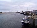
 Amble pier
 -
 The sundial in the town square and the eastern end of Queen Street.


