
21st Street–Queensbridge station: Difference between revisions
m WP:CHECKWIKI error fix for #16. Remove invisible Unicode characters. Do general fixes if a problem exists. -, replaced: → using AWB (11914) |
Cyberbot II (talk | contribs) Rescuing 1 sources. #IABot |
||
| Line 70: | Line 70: | ||
This underground station's only [[mezzanine (architecture)|mezzanine]] is at the east end of station adjacent to the Manhattan-bound platform. Access to both platforms is via an overpass above the tracks, with staircases, escalators and elevators to platform level. At this point, the station has a high ceiling.<ref name=NYCDCP-SilvercupWestTransit>{{cite web|title=Silvercup West FEIS:10.0 Transit and Pedestrians|url=http://www.nyc.gov/html/dcp/pdf/env_review/silvercup_west/ch10_feis.pdf#page=6|website=[[Government of New York City|nyc.gov]]|publisher=[[New York City Department of City Planning]]|archiveurl=http://web.archive.org/web/20061013231112/http://www.nyc.gov/html/dcp/pdf/env_review/silvercup_west/ch10_feis.pdf#page=6|archivedate=2006-10-13|deadurl=no|accessdate=27 September 2015}}</ref> The platform walls as well as the floor are made of brick, and towards the top of the platform walls is a line of larger brown sheets, on these are the station signs at regular intervals that say 21 Street-Queensbridge. Above this is a thin black strip of metal and above this are yellow squares that take the platform walls up to the station ceiling that is made of concrete. The mezzanine has two street stairs at the northeast corner of 21st Street and 41st Avenue. An elevator and escalators are at the northwest corner of the same intersection.<ref name=MTAMaps-LICQnsBdg-RsvltIs-2015>{{cite web|title=MTA Neighborhood Maps: Long Island City|url=http://web.mta.info/maps/neighborhoods/qns/Q3-LIC_2015.pdf|publisher=[[Metropolitan Transit Authority (New York)]]|accessdate=27 September 2015|date=2015}}</ref><ref name=NYCDCP-SilvercupWestTransit/> The two [[side platform]]s do not have yellow tactile strip with bumps or columns, characteristics of newly renovated and [[Americans with Disabilities Act of 1990|ADA-accessible]] New York City Subway stations. There are also no columns between the two tracks or on the platforms, except near the mezzanine and overpass.<ref name=NYTimes-NYCSvsWorld-63Archer-1976 /><ref name=NYCDCP-SilvercupWestTransit/> |
This underground station's only [[mezzanine (architecture)|mezzanine]] is at the east end of station adjacent to the Manhattan-bound platform. Access to both platforms is via an overpass above the tracks, with staircases, escalators and elevators to platform level. At this point, the station has a high ceiling.<ref name=NYCDCP-SilvercupWestTransit>{{cite web|title=Silvercup West FEIS:10.0 Transit and Pedestrians|url=http://www.nyc.gov/html/dcp/pdf/env_review/silvercup_west/ch10_feis.pdf#page=6|website=[[Government of New York City|nyc.gov]]|publisher=[[New York City Department of City Planning]]|archiveurl=http://web.archive.org/web/20061013231112/http://www.nyc.gov/html/dcp/pdf/env_review/silvercup_west/ch10_feis.pdf#page=6|archivedate=2006-10-13|deadurl=no|accessdate=27 September 2015}}</ref> The platform walls as well as the floor are made of brick, and towards the top of the platform walls is a line of larger brown sheets, on these are the station signs at regular intervals that say 21 Street-Queensbridge. Above this is a thin black strip of metal and above this are yellow squares that take the platform walls up to the station ceiling that is made of concrete. The mezzanine has two street stairs at the northeast corner of 21st Street and 41st Avenue. An elevator and escalators are at the northwest corner of the same intersection.<ref name=MTAMaps-LICQnsBdg-RsvltIs-2015>{{cite web|title=MTA Neighborhood Maps: Long Island City|url=http://web.mta.info/maps/neighborhoods/qns/Q3-LIC_2015.pdf|publisher=[[Metropolitan Transit Authority (New York)]]|accessdate=27 September 2015|date=2015}}</ref><ref name=NYCDCP-SilvercupWestTransit/> The two [[side platform]]s do not have yellow tactile strip with bumps or columns, characteristics of newly renovated and [[Americans with Disabilities Act of 1990|ADA-accessible]] New York City Subway stations. There are also no columns between the two tracks or on the platforms, except near the mezzanine and overpass.<ref name=NYTimes-NYCSvsWorld-63Archer-1976 /><ref name=NYCDCP-SilvercupWestTransit/> |
||
Until the connection to the Queens Boulevard Line opened, this station shared the characteristic of a two side platformed terminal station with [[Flatbush Avenue – Brooklyn College (IRT Nostrand Avenue Line)|Flatbush Avenue – Brooklyn College]] on the [[IRT Nostrand Avenue Line]]. This is an inefficient terminal setup,<ref name="int-arch">{{cite web | title=Full text of "Metropolitan transportation, a program for action. Report to Nelson A. Rockefeller, Governor of New York." | website=Internet Archive | date=November 7, 1967 | url=https://archive.org/stream/metropolitantran00newy/metropolitantran00newy_djvu.txt | accessdate=October 1, 2015}}</ref> requiring passengers to know which track the next train will depart from before going to the platform level. As a terminal from 1989 to 2001, the station had tail tracks that continued eastward as far as 29th Street, ending at [[bumper block]]s.<ref>{{cite web|title=PLAYING IN THE NEIGHBORHOOD: LONG ISLAND CITY; Tortoise Heads Into Queens|url=http://www.nytimes.com/1998/10/18/nyregion/playing-in-the-neighborhood-long-island-city-tortoise-heads-into-queens.html|publisher=[[The New York Times]]|accessdate=27 September 2015|date=October 18, 1998}}</ref> Also, this station has "[[punch box]]es", with buttons to indicate route selection to the train dispatcher; a control tower on the west end of [[Manhattan]]-bound platform, which can be used if necessary; and a [[diamond crossover]] switch to the west which was used to turn trains.<ref>{{Cite web|title |
Until the connection to the Queens Boulevard Line opened, this station shared the characteristic of a two side platformed terminal station with [[Flatbush Avenue – Brooklyn College (IRT Nostrand Avenue Line)|Flatbush Avenue – Brooklyn College]] on the [[IRT Nostrand Avenue Line]]. This is an inefficient terminal setup,<ref name="int-arch">{{cite web | title=Full text of "Metropolitan transportation, a program for action. Report to Nelson A. Rockefeller, Governor of New York." | website=Internet Archive | date=November 7, 1967 | url=https://archive.org/stream/metropolitantran00newy/metropolitantran00newy_djvu.txt | accessdate=October 1, 2015}}</ref> requiring passengers to know which track the next train will depart from before going to the platform level. As a terminal from 1989 to 2001, the station had tail tracks that continued eastward as far as 29th Street, ending at [[bumper block]]s.<ref>{{cite web|title=PLAYING IN THE NEIGHBORHOOD: LONG ISLAND CITY; Tortoise Heads Into Queens|url=http://www.nytimes.com/1998/10/18/nyregion/playing-in-the-neighborhood-long-island-city-tortoise-heads-into-queens.html|publisher=[[The New York Times]]|accessdate=27 September 2015|date=October 18, 1998}}</ref> Also, this station has "[[punch box]]es", with buttons to indicate route selection to the train dispatcher; a control tower on the west end of [[Manhattan]]-bound platform, which can be used if necessary; and a [[diamond crossover]] switch to the west which was used to turn trains.<ref>{{Cite web|title=F Train |url=http://www.stationreporter.net/ftrain.htm |date=2012-02-04 |access-date=2016-02-19 |deadurl=yes |archiveurl=https://web.archive.org/web/20120204051254/http://www.stationreporter.net/ftrain.htm |archivedate=February 4, 2012 }}</ref> |
||
East of the station, before the line connects to the [[IND Queens Boulevard Line]], the tracks veer left while the tunnel wall goes straight.<ref name=MTA63rdQBLConnectorTrackMap>{{cite web|title=MTA 63rd Street Connector|url=http://nycsubway.org.s3.amazonaws.com/images/logo/63rdconn.jpg|publisher=[[Metropolitan Transit Authority (New York)]]|accessdate=1 October 2015|archiveurl=http://web.archive.org/web/20141030120053/http://nycsubway.org.s3.amazonaws.com/images/logo/63rdconn.jpg|deadurl=no|archivedate=2014-10-30}}</ref><ref>{{cite web|url=http://www.youtube.com/watch?v=6aHFItRehRA&feature=related|title=Railfan Window Of An R32 F Train From 57th Street to 36th Street, Queens Part Two (''The bellmouth for the intended super-express bypass can be seen towards the right, at the 3:09 mark into the video.'')|author=Caitsith810|publisher=Youtube|date=December 17, 2008|accessdate=September 2013}}</ref> This [[Bellmouth (railroad terminology)|bellmouth]] is part of an intended [[Queens Super-Express Bypass|"super-express" bypass of the IND Queens Boulevard Line]] running along the [[Main Line (Long Island Rail Road)|mainline]] of the [[Long Island Rail Road]] between Queens Boulevard and [[Forest Hills – 71st Avenue (IND Queens Boulevard Line)|Forest Hills – 71st Avenue]] planned in 1968. At a proposed station at [[New York State Route 25A|Northern Boulevard]], for which the 29th Street tail tracks might have been built, a transfer concourse would have allowed transfers between local, express, and bypass trains.<ref name=NYTimes-QBLBypassDelay-1976 /><ref name=NYTimes-QBLBypassDelay2(Map)-1976 /><ref name=NYTimes-63StLightEndTunnel-1976/><ref name=NYTimes-NYCSvsWorld-63Archer-1976 /> |
East of the station, before the line connects to the [[IND Queens Boulevard Line]], the tracks veer left while the tunnel wall goes straight.<ref name=MTA63rdQBLConnectorTrackMap>{{cite web|title=MTA 63rd Street Connector|url=http://nycsubway.org.s3.amazonaws.com/images/logo/63rdconn.jpg|publisher=[[Metropolitan Transit Authority (New York)]]|accessdate=1 October 2015|archiveurl=http://web.archive.org/web/20141030120053/http://nycsubway.org.s3.amazonaws.com/images/logo/63rdconn.jpg|deadurl=no|archivedate=2014-10-30}}</ref><ref>{{cite web|url=http://www.youtube.com/watch?v=6aHFItRehRA&feature=related|title=Railfan Window Of An R32 F Train From 57th Street to 36th Street, Queens Part Two (''The bellmouth for the intended super-express bypass can be seen towards the right, at the 3:09 mark into the video.'')|author=Caitsith810|publisher=Youtube|date=December 17, 2008|accessdate=September 2013}}</ref> This [[Bellmouth (railroad terminology)|bellmouth]] is part of an intended [[Queens Super-Express Bypass|"super-express" bypass of the IND Queens Boulevard Line]] running along the [[Main Line (Long Island Rail Road)|mainline]] of the [[Long Island Rail Road]] between Queens Boulevard and [[Forest Hills – 71st Avenue (IND Queens Boulevard Line)|Forest Hills – 71st Avenue]] planned in 1968. At a proposed station at [[New York State Route 25A|Northern Boulevard]], for which the 29th Street tail tracks might have been built, a transfer concourse would have allowed transfers between local, express, and bypass trains.<ref name=NYTimes-QBLBypassDelay-1976 /><ref name=NYTimes-QBLBypassDelay2(Map)-1976 /><ref name=NYTimes-63StLightEndTunnel-1976/><ref name=NYTimes-NYCSvsWorld-63Archer-1976 /> |
||
Revision as of 05:11, 29 March 2016
21st Street – Queensbridge | |||||||
|---|---|---|---|---|---|---|---|
 View of the station facing east | |||||||
| Station statistics | |||||||
| Address | 21st Street & 41st Avenue Queens, NY 11101 | ||||||
| Borough | Queens | ||||||
| Locale | Queensbridge and Long Island City | ||||||
| Coordinates | 40°45′14″N 73°56′33″W / 40.753954°N 73.942451°W | ||||||
| Division | B (IND)[1] | ||||||
| Line | IND 63rd Street Line | ||||||
| Services | F | ||||||
| Transit | |||||||
| Structure | Underground | ||||||
| Platforms | 2 side platforms | ||||||
| Tracks | 2 | ||||||
| Other information | |||||||
| Opened | October 29, 1989[2] | ||||||
| Accessible | |||||||
| Opposite- direction transfer | Yes | ||||||
| Traffic | |||||||
| 2023 | 1,579,379[3] | ||||||
| Rank | 208 out of 423[3] | ||||||
| Station succession | |||||||
| Next north | Template:NYCS next Template:NYCS next | ||||||
| Next south | Template:NYCS next | ||||||
| |||||||
| |||||||
| |||||||


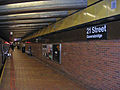
21st Street – Queensbridge is a station on the IND 63rd Street Line of the New York City Subway. Located at the intersection of 21st Street and 41st Avenue in the Queens neighborhood of Queensbridge, it is served by the F train at all times.
History
The current 63rd Street Line was the final version of proposals for a north midtown tunnel from the IND Queens Boulevard Line to the Second and Sixth Avenue lines, which date back to the IND Second System of the 1920s and 1930s.[5][6][7][8] The current plans were drawn up in the 1960s under the MTA's Program For Action.[9] In the original 1960s plans, there would have been a station (in addition to or as an alternative to 21st Street – Queensbridge) located farther east at Northern Boulevard, one block north of the Queens Plaza station of the Queens Boulevard line. There would have been a pedestrian transfer passageway between the two stations.[10][11][12][13][14]
The station was placed at 21st Street, serving the Queensbridge Houses to the west, and commercial and industrial buildings to the east. The station was added to the plans following lobbying from the local community.[14][15][16] During construction, a large amount of disturbance was created along 41st Avenue, which runs through the heart of Queensbridge.[14] This station opened on October 29, 1989[17] along with the entire IND 63rd Street Line, serving as the line's northern terminal prior to the connection with the IND Queens Boulevard Line.[2][18] Q trains (weekdays) and B trains (weekends) from the Sixth Avenue Line served the station, along with the JFK Express to Kennedy Airport.[2] The tunnel had gained notoriety as the "tunnel to nowhere" both during its planning and after its opening, with 21st Street being the line's only stop in Queens.[2][8] The connection to the Queens Boulevard Line began in 1994 and was completed and opened in 2001, almost thirty years after construction of the 63rd Street Tunnel began.[19][20][21][22][23]
Station layout
| G | Street Level | Exit/Entrance |
| B1 | Mezzanine | Fare control, station agent, MetroCard vending machines, crossover |
| B2 | Side platform, doors will open on the right | |
| Southbound | ← Template:NYCS-bull-small toward Coney Island – Stillwell Avenue (Roosevelt Island) | |
| Northbound | → Template:NYCS-bull-small toward Jamaica – 179th Street (Jackson Heights – Roosevelt Avenue) → (No regular service: 36th Street) | |
| Side platform, doors will open on the right | ||
| B3 | Track 1 | ← LIRR East Side Access (under construction) |
| Track 2 | → LIRR East Side Access (under construction) → | |
This underground station's only mezzanine is at the east end of station adjacent to the Manhattan-bound platform. Access to both platforms is via an overpass above the tracks, with staircases, escalators and elevators to platform level. At this point, the station has a high ceiling.[24] The platform walls as well as the floor are made of brick, and towards the top of the platform walls is a line of larger brown sheets, on these are the station signs at regular intervals that say 21 Street-Queensbridge. Above this is a thin black strip of metal and above this are yellow squares that take the platform walls up to the station ceiling that is made of concrete. The mezzanine has two street stairs at the northeast corner of 21st Street and 41st Avenue. An elevator and escalators are at the northwest corner of the same intersection.[16][24] The two side platforms do not have yellow tactile strip with bumps or columns, characteristics of newly renovated and ADA-accessible New York City Subway stations. There are also no columns between the two tracks or on the platforms, except near the mezzanine and overpass.[13][24]
Until the connection to the Queens Boulevard Line opened, this station shared the characteristic of a two side platformed terminal station with Flatbush Avenue – Brooklyn College on the IRT Nostrand Avenue Line. This is an inefficient terminal setup,[9] requiring passengers to know which track the next train will depart from before going to the platform level. As a terminal from 1989 to 2001, the station had tail tracks that continued eastward as far as 29th Street, ending at bumper blocks.[25] Also, this station has "punch boxes", with buttons to indicate route selection to the train dispatcher; a control tower on the west end of Manhattan-bound platform, which can be used if necessary; and a diamond crossover switch to the west which was used to turn trains.[26]
East of the station, before the line connects to the IND Queens Boulevard Line, the tracks veer left while the tunnel wall goes straight.[27][28] This bellmouth is part of an intended "super-express" bypass of the IND Queens Boulevard Line running along the mainline of the Long Island Rail Road between Queens Boulevard and Forest Hills – 71st Avenue planned in 1968. At a proposed station at Northern Boulevard, for which the 29th Street tail tracks might have been built, a transfer concourse would have allowed transfers between local, express, and bypass trains.[10][11][12][13]
Gallery
-
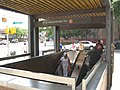
 View of the overpass and station architecture.
 -
 Street elevator
 -
 Street escalators
 -
 Platform
 -
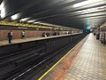 View of the platforms facing west


References
- ^ "Glossary". Second Avenue Subway Supplemental Draft Environmental Impact Statement (SDEIS) (PDF). Vol. 1. Metropolitan Transportation Authority. March 4, 2003. pp. 1–2. Archived from the original (PDF) on February 26, 2021. Retrieved January 1, 2021.
- ^ a b c d Lorch, Donatella (October 29, 1989). "The 'Subway to Nowhere' Now Goes Somewhere". The New York Times. Retrieved 2009-09-26.
- ^ a b "Annual Subway Ridership (2018–2023)". Metropolitan Transportation Authority. 2023. Retrieved April 20, 2024.
- ^ "Facts and Figures: Annual Subway Ridership". Metropolitan Transportation Authority. Retrieved 2015-04-27.
- ^ Joseph B. Raskin (1 November 2013). The Routes Not Taken: A Trip Through New York City's Unbuilt Subway System. Fordham University Press. ISBN 978-0-8232-5369-2. Retrieved 12 August 2015.
- ^ Roger P. Roess; Gene Sansone (23 August 2012). The Wheels That Drove New York: A History of the New York City Transit System. Springer Science & Business Media. pp. 416–417. ISBN 978-3-642-30484-2.
- ^ Project for Expanded Rapid Transit Facilities, New York City Transit System, dated July 5, 1939
- ^ a b Knowles, Clayton (December 16, 1964). "Proposed Subway Tube Assailed As 'Nowhere‐to‐Nowhere' Link". The New York Times. Retrieved 27 September 2015.
- ^ a b "Full text of "Metropolitan transportation, a program for action. Report to Nelson A. Rockefeller, Governor of New York."". Internet Archive. November 7, 1967. Retrieved October 1, 2015.
- ^ a b Burks, Edward C. (June 6, 1976). "Shortage of U.S. Funds May Delay Subway Link". The New York Times. Retrieved 27 September 2015.
- ^ a b Burks, Edward C. (July 29, 1976). "New Subway Line Delayed 5 or 6 Years". The New York Times. Retrieved 27 September 2015.
- ^ a b Burks, Edward C. (September 24, 1976). "Coming: Light at End of 63d St. Tunnel". The New York Times. Retrieved 27 September 2015.
- ^ a b c Burks, Edward C. (August 7, 1976). "New York Improving Subway, But Still Trails Foreign Cities". The New York Times. Retrieved 27 September 2015.
- ^ a b c Lichtenstein, Grace (May 9, 1978). "Planned 40-Mile Queens Subway, Cut to 15, is Costly and Behind Time". The New York Times. p. 68. Retrieved October 20, 2011.
- ^ Daley, Suzanne (November 1, 1984). "63D ST. SUBWAY TUNNEL: MORE SETBACKS FOR A TROUBLED PROJECT". The New York Times. Retrieved 27 September 2015.
- ^ a b "MTA Neighborhood Maps: Long Island City" (PDF). Metropolitan Transit Authority (New York). 2015. Retrieved 27 September 2015.
- ^ 63 St Subway Extension Opened 25 Years Ago this Week
- ^ Kershaw, Sarah (December 17, 2001). "V Train Begins Service Today, Giving Queens Commuters Another Option". The New York Times. Retrieved 2011-10-16.
- ^ "Review of F Line Operations, Ridership, and Infrastructure" (PDF). nysenate.gov. MTA New York City Transit Authority. October 7, 2009. Retrieved 28 July 2015.
- ^ "Review of the G Line" (PDF). mta.info. Metropolitan Transit Authority (New York). July 10, 2013. Retrieved 2 August 2015.
- ^ O'Neill, Natalie (April 13, 2012). "History shows it's not the G train 'extension' — it's the G train renewal". The Brooklyn Paper. Retrieved 2 August 2015.
- ^ "E,F Detour in 2001, F trains via 63 St, E no trains running, take R instead". The Subway Nut. Retrieved October 20, 2011.
- ^ Kennedy, Randy (May 25, 2001). "Panel Approves New V Train but Shortens G Line to Make Room". The New York Times. Retrieved March 20, 2010.
- ^ a b c "Silvercup West FEIS:10.0 Transit and Pedestrians" (PDF). nyc.gov. New York City Department of City Planning. Archived from the original (PDF) on 2006-10-13. Retrieved 27 September 2015.
{{cite web}}: Unknown parameter|deadurl=ignored (|url-status=suggested) (help) - ^ "PLAYING IN THE NEIGHBORHOOD: LONG ISLAND CITY; Tortoise Heads Into Queens". The New York Times. October 18, 1998. Retrieved 27 September 2015.
- ^ "F Train". 2012-02-04. Archived from the original on February 4, 2012. Retrieved 2016-02-19.
{{cite web}}: Unknown parameter|deadurl=ignored (|url-status=suggested) (help) - ^ "MTA 63rd Street Connector". Metropolitan Transit Authority (New York). Archived from the original on 2014-10-30. Retrieved 1 October 2015.
{{cite web}}: Unknown parameter|deadurl=ignored (|url-status=suggested) (help) - ^ Caitsith810 (December 17, 2008). "Railfan Window Of An R32 F Train From 57th Street to 36th Street, Queens Part Two (The bellmouth for the intended super-express bypass can be seen towards the right, at the 3:09 mark into the video.)". Youtube. Retrieved September 2013.
{{cite web}}: Check date values in:|accessdate=(help)CS1 maint: numeric names: authors list (link)
External links
| 63rd St. Lines |
|
|---|---|
| |