
Meillonnas: Difference between revisions
Content deleted Content added
Rescuing 1 sources and tagging 0 as dead. #IABot (v1.1) |
|||
| Line 55: | Line 55: | ||
==References== |
==References== |
||
*[http://www.insee.fr/en/home/home_page.asp INSEE] |
*[https://web.archive.org/web/20071124142010/http://www.insee.fr/en/home/home_page.asp INSEE] |
||
{{reflist}} |
{{reflist}} |
||
Revision as of 17:02, 21 July 2016
You can help expand this article with text translated from the corresponding article in French. (December 2008) Click [show] for important translation instructions.
|
Meillonnas | |
|---|---|
 | |
 Coat of arms | |
Location of Meillonnas  | |
| Country | France |
| Region | Auvergne-Rhône-Alpes |
| Department | Ain |
| Arrondissement | Bourg-en-Bresse |
| Canton | Treffort-Cuisiat |
| Intercommunality | Treffort-en-Revermont |
| Government | |
| • Mayor (2010–2014) | Jean-Paul Neveu |
| Area 1 | 17.74 km2 (6.85 sq mi) |
| Population (2008) | 1,298 |
| • Density | 73/km2 (190/sq mi) |
| Time zone | UTC+01:00 (CET) |
| • Summer (DST) | UTC+02:00 (CEST) |
| INSEE/Postal code | 01241 /01370 |
| Elevation | 232–460 m (761–1,509 ft) (avg. 279 m or 915 ft) |
| 1 French Land Register data, which excludes lakes, ponds, glaciers > 1 km2 (0.386 sq mi or 247 acres) and river estuaries. | |
Meillonnas is a commune in the Ain department in eastern France.
Geography
The Sevron has its source in the commune; it crosses the village and forms part of the commune's northern border.
The bief du Bois Tharlet, a tributary of the Sevron, forms most of the commune's western border.
Population
| Year | Pop. | ±% |
|---|---|---|
| 1962 | 610 | — |
| 1968 | 630 | +3.3% |
| 1975 | 671 | +6.5% |
| 1982 | 891 | +32.8% |
| 1990 | 1,051 | +18.0% |
| 1999 | 1,204 | +14.6% |
| 2008 | 1,298 | +7.8% |
-
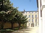 Hotel of Meillonnas
 -
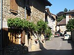 Ancient Street


See also
References
Wikimedia Commons has media related to Meillonnas.
This Ain geographical article is a stub. You can help Wikipedia by expanding it. |