
Bellows Falls, Vermont: Difference between revisions
m →History: http→https for Google Books and Google News using AWB |
Rescuing 4 sources and tagging 0 as dead. #IABot (v1.2.6) |
||
| Line 77: | Line 77: | ||
|area_code = [[Area code 802|802]] |
|area_code = [[Area code 802|802]] |
||
|blank_name = [[Federal Information Processing Standard|FIPS code]] |
|blank_name = [[Federal Information Processing Standard|FIPS code]] |
||
|blank_info = 50-04225<ref name="GR2">{{cite web|url=http://factfinder2.census.gov|publisher=[[United States Census Bureau]]|accessdate=2008-01-31|title=American FactFinder}}</ref> |
|blank_info = 50-04225<ref name="GR2">{{cite web|url=http://factfinder2.census.gov |publisher=[[United States Census Bureau]] |accessdate=2008-01-31 |title=American FactFinder |deadurl=yes |archiveurl=https://web.archive.org/web/20130911234518/http://factfinder2.census.gov |archivedate=2013-09-11 |df= }}</ref> |
||
|blank1_name = [[Geographic Names Information System|GNIS]] feature ID |
|blank1_name = [[Geographic Names Information System|GNIS]] feature ID |
||
|blank1_info = 1456381<ref name="GR3">{{cite web|url=http://geonames.usgs.gov|accessdate=2008-01-31|title=US Board on Geographic Names|publisher=[[United States Geological Survey]]|date=2007-10-25}}</ref> |
|blank1_info = 1456381<ref name="GR3">{{cite web|url=http://geonames.usgs.gov|accessdate=2008-01-31|title=US Board on Geographic Names|publisher=[[United States Geological Survey]]|date=2007-10-25}}</ref> |
||
| Line 120: | Line 120: | ||
|estimate=3048 |
|estimate=3048 |
||
|estref=<ref name="USCensusEst2015">{{cite web|url=http://www.census.gov/popest/data/cities/totals/2015/SUB-EST2015.html|title=Annual Estimates of the Resident Population for Incorporated Places: April 1, 2010 to July 1, 2015|accessdate=July 2, 2016}}</ref> |
|estref=<ref name="USCensusEst2015">{{cite web|url=http://www.census.gov/popest/data/cities/totals/2015/SUB-EST2015.html|title=Annual Estimates of the Resident Population for Incorporated Places: April 1, 2010 to July 1, 2015|accessdate=July 2, 2016}}</ref> |
||
|footnote=<center>U.S. Decennial Census<ref name="DecennialCensus">{{cite web|url=http://www.census.gov/prod/www/decennial.html|title=Census of Population and Housing|publisher=Census.gov|accessdate=June 4, 2015}}</ref></center> |
|footnote=<center>U.S. Decennial Census<ref name="DecennialCensus">{{cite web|url=http://www.census.gov/prod/www/decennial.html |title=Census of Population and Housing |publisher=Census.gov |accessdate=June 4, 2015 |deadurl=yes |archiveurl=http://www.webcitation.org/6YSasqtfX?url=http%3A%2F%2Fwww.census.gov%2Fprod%2Fwww%2Fdecennial.html |archivedate=May 11, 2015 |df= }}</ref></center> |
||
}} |
}} |
||
As of the [[census]]<ref name="GR2" /> of 2000, there were 3,165 people, 1,329 households, and 782 families residing in the village. The [[population density]] was 2,286.1 people per square mile (885.5/km<sup>2</sup>). There were 1,443 housing units at an average density of 1,042.3/sq mi (403.7/km<sup>2</sup>). The racial makeup of the village was 97.28% [[White (U.S. Census)|White]], 0.35% [[African American (U.S. Census)|African American]], 0.16% [[Native American (U.S. Census)|Native American]], 0.51% [[Asian (U.S. Census)|Asian]], 0.03% [[Pacific Islander (U.S. Census)|Pacific Islander]], 0.22% from [[Race (United States Census)|other races]], and 1.45% from two or more races. [[Hispanic (U.S. Census)|Hispanic]] or [[Latino (U.S. Census)|Latino]] of any race were 1.14% of the population. |
As of the [[census]]<ref name="GR2" /> of 2000, there were 3,165 people, 1,329 households, and 782 families residing in the village. The [[population density]] was 2,286.1 people per square mile (885.5/km<sup>2</sup>). There were 1,443 housing units at an average density of 1,042.3/sq mi (403.7/km<sup>2</sup>). The racial makeup of the village was 97.28% [[White (U.S. Census)|White]], 0.35% [[African American (U.S. Census)|African American]], 0.16% [[Native American (U.S. Census)|Native American]], 0.51% [[Asian (U.S. Census)|Asian]], 0.03% [[Pacific Islander (U.S. Census)|Pacific Islander]], 0.22% from [[Race (United States Census)|other races]], and 1.45% from two or more races. [[Hispanic (U.S. Census)|Hispanic]] or [[Latino (U.S. Census)|Latino]] of any race were 1.14% of the population. |
||
| Line 175: | Line 175: | ||
==Sites of interest== |
==Sites of interest== |
||
* [http://www.vmga.org/windham/adamnsgm.html Adams Grist Mill Museum] |
* [https://web.archive.org/web/20091207021034/http://www.vmga.org:80/windham/adamnsgm.html Adams Grist Mill Museum] |
||
* [http://www.museumsusa.org/museums/info/1161696 Bellows Falls Historical Society & Museum] |
* [http://www.museumsusa.org/museums/info/1161696 Bellows Falls Historical Society & Museum] |
||
* [http://www.rockbf.org/index.asp?Type=B_EV&SEC=%7BC932F43E-A9D4-4BE2-9420-F478431D787F%7D Bellows Falls Opera House] |
* [http://www.rockbf.org/index.asp?Type=B_EV&SEC=%7BC932F43E-A9D4-4BE2-9420-F478431D787F%7D Bellows Falls Opera House] |
||
| Line 220: | Line 220: | ||
* [http://www.rootsontheriver.com/ Roots on the River Festival] |
* [http://www.rootsontheriver.com/ Roots on the River Festival] |
||
* [http://www.missbellowsfallsdiner.com/ Miss Bellows Falls Diner] |
* [http://www.missbellowsfallsdiner.com/ Miss Bellows Falls Diner] |
||
* [http://www.vt-rails.com |
* [https://web.archive.org/web/20130826175958/http://www.vt-rails.com Green Mountain Railroad] |
||
{{Windham County, Vermont}} |
{{Windham County, Vermont}} |
||
Revision as of 11:12, 30 October 2016
Bellows Falls, Vermont | |
|---|---|
 Bellows Falls in the early spring, viewed from Fall Mountain | |
| Country | United States |
| State | Vermont |
| County | Windham |
| Incorporated | 1909 |
| Area | |
| • Total | 1.4 sq mi (3.6 km2) |
| • Land | 1.4 sq mi (3.6 km2) |
| • Water | 0.0 sq mi (0.0 km2) |
| Elevation | 312 ft (95 m) |
| Population (2000) | |
| • Total | 3,165 |
| • Density | 2,286.1/sq mi (882.7/km2) |
| Time zone | UTC-5 (Eastern (EST)) |
| • Summer (DST) | UTC-4 (EDT) |
| ZIP code | 05101 |
| Area code | 802 |
| FIPS code | 50-04225[1] |
| GNIS feature ID | 1456381[2] |
Bellows Falls is an incorporated village located in the town of Rockingham in Windham County, Vermont, United States. The population was 3,165 at the 2000 census. Bellows Falls is home to the Green Mountain Railroad, a heritage railroad; the annual Roots on the River Festival;[3] and the No Film Film Festival.[4]
History
The falls were once a fishing place for the historic, nomadic Abenaki tribes, who were part of the Algonquian language family. They caught plentiful salmon and shad. Indigenous peoples had fished at the falls and inhabited the area for thousands of years before European arrival. They carved two sets of faces in the rocks just below the falls (see Bellows Falls Petroglyph Site (VT-WD-8)).
The community was settled in 1753 by colonists of English descent, who called it Great Falls. Later the settlers named the town for Colonel Benjamin Bellows, a landowner.[5] In 1785, Colonel Enoch Hale built at the falls the first bridge over the Connecticut River. It was the only bridge across the river until 1796, when another was built at Springfield, Massachusetts.[6] The bridge was later replaced. Two bridges currently link Bellows Falls to New Hampshire: the New Arch Bridge (also called the Church Street Bridge), which replaced the Arch Bridge in 1982, and the Vilas Bridge,[7] which was closed due to safety concerns in 2009.
The Bellows Falls Canal, built in 1791-1802, lifted boats 52 feet (16 m) in eight locks around the gorge. It tapped the water power of the falls for industry, which spurred the industrialization of the town.[8]
In 1802, entrepreneurs built the first paper mill in Windham County. Two railroads converged in 1849 at Bellows Falls, helping it develop into a major mill town. By 1859, a woolen textile mill was operating, in addition to factories that produced furniture, marble, sashes and blinds, iron castings, carriages, cabinetware, rifles, harness, shoe pegs and organs.[9] The principal products, however, were paper and farm machinery. Bellows Falls was incorporated as a village in 1909.
The years of industry created wealth in the town, and substantial Victorian houses and mercantile buildings were constructed. Bellows Falls today attracts visitors through heritage tourism based on its historic Victorian architecture. The commercial town center, along with the power canal, the bridges spanning it, and the historic railroad station, were listed as a historic district on the National Register of Historic Places in 1982.[10][11]
Geography
The village is located within the town of Rockingham. According to the United States Census Bureau, the village has a total area of 1.4 square miles (3.6 km2), all land. Bellows Falls is bounded on the east by the Connecticut River.
Demographics
| Census | Pop. | Note | %± |
|---|---|---|---|
| 1870 | 697 | — | |
| 1880 | 2,229 | 219.8% | |
| 1890 | 3,092 | 38.7% | |
| 1900 | 4,337 | 40.3% | |
| 1910 | 4,883 | 12.6% | |
| 1920 | 4,860 | −0.5% | |
| 1930 | 3,930 | −19.1% | |
| 1940 | 4,236 | 7.8% | |
| 1950 | 3,881 | −8.4% | |
| 1960 | 3,831 | −1.3% | |
| 1970 | 3,505 | −8.5% | |
| 1980 | 3,456 | −1.4% | |
| 1990 | 3,313 | −4.1% | |
| 2000 | 3,165 | −4.5% | |
| 2010 | 3,148 | −0.5% | |
| 2015 (est.) | 3,048 | [12] | −3.2% |
As of the census[1] of 2000, there were 3,165 people, 1,329 households, and 782 families residing in the village. The population density was 2,286.1 people per square mile (885.5/km2). There were 1,443 housing units at an average density of 1,042.3/sq mi (403.7/km2). The racial makeup of the village was 97.28% White, 0.35% African American, 0.16% Native American, 0.51% Asian, 0.03% Pacific Islander, 0.22% from other races, and 1.45% from two or more races. Hispanic or Latino of any race were 1.14% of the population.
There were 1,329 households out of which 32.2% had children under the age of 18 living with them, 40.0% were couples living together and joined in either marriage or civil union, 14.1% had a female householder with no husband present, and 41.1% were non-families. 34.5% of all households were made up of individuals and 16.7% had someone living alone who was 65 years of age or older. The average household size was 2.35 and the average family size was 3.01.
In the village the population was spread out with 26.1% under the age of 18, 7.8% from 18 to 24, 28.3% from 25 to 44, 21.5% from 45 to 64, and 16.2% who were 65 years of age or older. The median age was 37 years. For every 100 females there were 94.1 males. For every 100 females age 18 and over, there were 88.6 males.
The median income for a household in the village was $29,608, and the median income for a family was $45,688. Males had a median income of $29,137 versus $22,340 for females. The per capita income for the village was $15,276. About 5.6% of families and 12.6% of the population were below the poverty line, including 14.3% of those under age 18 and 15.9% of those age 65 or over.
Transportation
Amtrak, the national passenger rail system, provides daily service through Bellows Falls, operating its Vermonter between Washington, D.C. and St. Albans, Vermont. The Bellows Falls Station, on Depot Street, also serves as the headquarters for the Green Mountain Railroad. Greyhound, the nationwide intercity bus service, also serves Bellows Falls from this same rail station.
Connecticut River Transit, a private, non-profit personal mobility specialist, provides scheduled bus service with local and direct buses linking Bellows Falls, Brattleboro, Springfield, Ludlow, the White River Junction and Lebanon, New Hampshire areas and other local communities as needed by private arrangement.
Green Mountain Railroad, a part of the Vermont Rail System, operates seasonal and holiday scenic train excursions between Bellows Falls and Chester. The New England Central Railroad also serves Bellows Falls.
The village is crossed by Interstate 91, U.S. Route 5, and Vermont Route 121.
Media
Radio
- WOOL 91.5 (Freeform, "Black Sheep Radio")
- WZLF 107.1 (Country, "95.3 and 107.1 The Wolf") a simulcast of WXLF from Hartford, Vermont
Antique postcards and other images
-
 Island House Hotel, c1850s
 -
 Paper mills in 1907
 -
 The Square c. 1908
 -
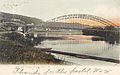
 Westminster High Bridge over Saxton's River in 1906
 -
-
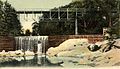
 Bellows Falls at high flow, under what is now the Vilas Bridge
 -
 Antique postcard of Bellows Falls (Great Falls) at high flow at Bellows Falls, VT
 -
 Bellows Falls under the Vilas Bridge at medium flow in 2014. Photo was taken looking north from the road along the shore in the village of Bellows Falls.


_River,_from_Vermont_side,_by_French_%26_Sawyer.jpg)


Listed on National Register of Historic Places

- Adams Gristmill Warehouse — Bridge St. (added February 22, 1990)
- Bellows Falls Co-operative Creamery Complex — Island St. (added February 22, 1990)
- Bellows Falls Neighborhood Historic District — Atkinson, Westminster, School, Hapgood Sts, Hapgood Pl., Burt St., Henry St., South St., Hadley St., Temple Pl. (added February 17, 2002)
- Bellows Falls Times Building — Bridge and Island Sts. (added February 22, 1990)
- Bellows Falls Downtown Historic District — Depot, Canal, Rockingham, Bridge, Mill and Westminster Sts. (added September 16, 1982)
- Bellows Falls Petroglyph Site (VT-WD-8) (added February 22, 1990)
- Hall Covered Bridge — W of Bellows Falls Across Saxtons River, off VT 121 (added September 28, 1973)
- Howard Hardware Storehouse — Bridge St. (added February 22, 1990)
- Miss Bellows Falls Diner — 90 Rockingham St. (added March 15, 1983)
- Moore and Thompson Paper Mill Complex — Bridge St. (added April 16, 1984)
- Oak Hill Cemetery Chapel — Off Pleasant St. (added December 14, 1991)
- Robertson Paper Company Complex — Island St. (added February 22, 1990)
- William A. Hall House — 1 Hapgood St. (added June 5, 1999)
Sites of interest
- Adams Grist Mill Museum
- Bellows Falls Historical Society & Museum
- Bellows Falls Opera House
- Green Mountain Railroad, a heritage railroad
- Rockingham Arts & Museum Project
Notable people

- Donald H. Balch (1931–2007), general in the United States Air Force
- Colleen Barrett (1944–), president of Southwest Airlines
- Arthur Chase (1835–1888), co-founder of Theta Chi Fraternity
- Sean O. Cota (1963–), businessman and financial commentator
- Carlton Fisk (1947–), catcher with the Boston Red Sox and Chicago White Sox
- Jay H. Gordon (1930–2007), politician and auditor of accounts
- Hetty Green (1834–1916), businesswoman
- Henry Alfred Hosking (1908–1957), member of the Canadian House of Commons
- James F. Howard, Jr. (1948–), professor of neurology and medicine
- Michael Palma (1945–), poet and translator
- Roger Robb (1907–1985), judge
- Thomas P. Salmon (1932–), 75th Governor of Vermont
- Jennie Maria Arms Sheldon (1852-1938), an entomologist, science educator, historian, author, and museum curator, was born in Bellows Falls
- Gary Smith, record producer
- Ernest Thompson (1949–), playwright and actor
See also
References
- ^ a b "American FactFinder". United States Census Bureau. Archived from the original on 2013-09-11. Retrieved 2008-01-31.
{{cite web}}: Unknown parameter|deadurl=ignored (|url-status=suggested) (help) - ^ "US Board on Geographic Names". United States Geological Survey. 2007-10-25. Retrieved 2008-01-31.
- ^ http://www.rootsontheriver.com
- ^ http://www.facebook.com/pages/No-Film-Film-Festival/293137604059968
- ^ Coolidge, Austin J.; John B. Mansfield (1859). A History and Description of New England. Boston, Massachusetts. pp. 886–888.
{{cite book}}: CS1 maint: location missing publisher (link) - ^ The First Toll Bridge at Bellows Falls
- ^ Around Bellows Falls: Rockingham, Westminster, and Saxtons River By Anne L. Collins, Virginia Lisai, and Louise Luring. Arcadia Publishing, 2002. ISBN 978-0-7385-1033-0
- ^ Bellows Falls Canal
- ^ A. J. Coolidge & J. B. Mansfield, A History and Description of New England; Boston, Massachusetts 1859
- ^ "National Register Information System". National Register of Historic Places. National Park Service. July 9, 2010.
- ^ "NRHP nomination for Bellows Falls Downtown Historic District". National Park Service. Retrieved 2015-10-31.
- ^ "Annual Estimates of the Resident Population for Incorporated Places: April 1, 2010 to July 1, 2015". Retrieved July 2, 2016.
- ^ "Census of Population and Housing". Census.gov. Archived from the original on May 11, 2015. Retrieved June 4, 2015.
{{cite web}}: Unknown parameter|deadurl=ignored (|url-status=suggested) (help)
External links
- Town of Rockingham & Village of Bellows Falls, Vermont
- Rockingham Free Public Library
- Roots on the River Festival
- Miss Bellows Falls Diner
- Green Mountain Railroad
Municipalities and communities of Windham County, Vermont, United States | ||
|---|---|---|
| Towns | ||
| Villages | ||
| CDPs | ||
| Other communities | ||
| Footnotes | § Disincorporated ‡ This populated place also has portions in an adjacent county or counties | |