
Aguilar, Pangasinan: Difference between revisions
m →top: clean up, replaced: | area_code_type = Dialing code → | area_code_type = {{areacodestyle}} using AWB |
Rescuing 4 sources and tagging 0 as dead. #IABot (v1.4beta) (Josve05a) |
||
| Line 34: | Line 34: | ||
| leader_title1 = Vice Mayor |
| leader_title1 = Vice Mayor |
||
| leader_name1 = Roldan Caoile Sagles |
| leader_name1 = Roldan Caoile Sagles |
||
| area_footnotes = <ref name=nscb>{{cite web |
| area_footnotes = <ref name=nscb>{{cite web|title=Province: PANGASINAN |url=http://www.nscb.gov.ph/activestats/psgc/province.asp?regName=REGION+I+%28Ilocos+Region%29®Code=01&provCode=015500000&provName=PANGASINAN |work=PSGC Interactive |publisher=National Statistical Coordination Board |accessdate=26 November 2012 |location=Makati City, Philippines |deadurl=yes |archiveurl=https://web.archive.org/web/20121114165526/http://www.nscb.gov.ph/activestats/psgc/province.asp?regName=REGION%20I%20%28Ilocos%20Region%29®Code=01&provCode=015500000&provName=PANGASINAN |archivedate=14 November 2012 |df= }}</ref> |
||
| area_total_km2 = 195.07 |
| area_total_km2 = 195.07 |
||
| elevation_footnotes = |
| elevation_footnotes = |
||
| Line 57: | Line 57: | ||
| blank1_info_sec1 = {{PH wikidata|income_class}} |
| blank1_info_sec1 = {{PH wikidata|income_class}} |
||
| blank2_name_sec1 = Revenue |
| blank2_name_sec1 = Revenue |
||
| blank2_info_sec1 = ₱ 9,550,248.44 (2016)<ref>{{cite web |
| blank2_info_sec1 = ₱ 9,550,248.44 (2016)<ref>{{cite web|url=http://www.competitive.org.ph/cmcindex/pages/province/?province=Pangasinan |title=Pangasinan : Cities and Municipalities Competitiveness Index |publisher=[[National Competitiveness Council (Philippines)]] |location=Makati City, Philippines |accessdate=28 January 2017 |deadurl=bot: unknown |archiveurl=https://web.archive.org/web/20170128105217/http://www.competitive.org.ph/cmcindex/pages/province/?province=Pangasinan |archivedate=28 January 2017 |df= }}</ref> |
||
| blank3_name_sec1 = [[Measuring poverty|Poverty incidence]] |
| blank3_name_sec1 = [[Measuring poverty|Poverty incidence]] |
||
| blank3_info_sec1 = 14.99 (2012)<ref>{{cite web |
| blank3_info_sec1 = 14.99 (2012)<ref>{{cite web|url=https://psa.gov.ph/content/psa-releases-2012-municipal-and-city-level-poverty-estimates |title=PSA Releases the 2012 Municipal and City Level Poverty Estimates |publisher=Philippine Statistics Authority |location=Quezon City, Philippines |accessdate=28 January 2017 |deadurl=bot: unknown |archiveurl=https://web.archive.org/web/20170128103307/https://psa.gov.ph/content/psa-releases-2012-municipal-and-city-level-poverty-estimates |archivedate=28 January 2017 |df= }}</ref> |
||
| website = {{Official URL}} |
| website = {{Official URL}} |
||
| footnotes = |
| footnotes = |
||
| Line 257: | Line 257: | ||
* [http://pangasinan.gov.ph/the-province/cities-and-municipalities/aguilar/ Aguilar at the Pangasinan Government Website] |
* [http://pangasinan.gov.ph/the-province/cities-and-municipalities/aguilar/ Aguilar at the Pangasinan Government Website] |
||
* [http://www.blgs.gov.ph/lgpmsv2/cmshome/index.php?pageID=23&frmIdDcfCode=7&fLguType=CM&frmIdRegion=2&frmIdProvince=21&frmIdLgu=298 Local Governance Performance Management System] |
* [http://www.blgs.gov.ph/lgpmsv2/cmshome/index.php?pageID=23&frmIdDcfCode=7&fLguType=CM&frmIdRegion=2&frmIdProvince=21&frmIdLgu=298 Local Governance Performance Management System] |
||
* [https://web.archive.org/web/20120413163013/http://www.nscb.gov.ph |
* [https://web.archive.org/web/20120413163013/http://www.nscb.gov.ph/activestats/psgc/default.asp Philippine Standard Geographic Code] |
||
* [https://web.archive.org/web/20081120024509/http://www.census.gov.ph/data/census2007/index.html Philippine Census Information] |
* [https://web.archive.org/web/20081120024509/http://www.census.gov.ph/data/census2007/index.html Philippine Census Information] |
||
* [https://web.archive.org/web/20120206103819/https://www.pangasinan.org/aguilar/ Pangasinan.org : Aguilar Family and School Reunion Archives] |
* [https://web.archive.org/web/20120206103819/https://www.pangasinan.org/aguilar/ Pangasinan.org : Aguilar Family and School Reunion Archives] |
||
Revision as of 17:48, 6 June 2017
Aguilar | |
|---|---|
 | |
 Seal | |
 Map of Pangasinan showing the location of Aguilar | |
.svg) Aguilar Location within the Philippines | |
| Coordinates: 15°50′N 120°12′E / 15.833°N 120.200°E | |
| Country | |
| Region | Ilocos (Region I) |
| Province | Pangasinan |
| District | 2nd district of Pangasinan |
| Founded | July 16, 1805 |
| Barangays | 16 |
| Government | |
| • Mayor | Eduardo T. Ballesteros |
| • Vice Mayor | Roldan Caoile Sagles |
| • Electorate | 29,400 voters (2022 election) |
| Area | |
| • Total | 195.07 km2 (75.32 sq mi) |
| Population (2020 census)[3] | |
| • Total | 45,100 |
| • Density | 230/km2 (600/sq mi) |
| Time zone | UTC+8 (PST) |
| ZIP code | 2415 |
| PSGC | 015502000 |
| IDD : area code | +63 (0)75 |
| Income class | 3rd municipal income class |
| Revenue | ₱ 9,550,248.44 (2016)[4] |
| Poverty incidence | 14.99 (2012)[5] |
| Website | www |
Aguilar is a 3rd class municipality in the province of Pangasinan, Philippines. According to the 2020 census, it has a population of 45,100 people.[3] The municipality was named after Spanish governor-general Rafael Maria de Aguilar, who ordered the establishment of an independent civil political unit on 16 July 1805
History
The Municipality of Aguilar had its early beginnings as cattle ranch founded by the Spaniards. The place was known then as Sitio Balubad, which was then still part of the town of Binalatongan (now San Carlos). On the western part were the Zambales Mountains with thick forests and verdant foliage. It was hunter's paradise with deer roaming here and there with an occasional wild boar making an appearance. The grass in the plains were succulent fare for fattening cattle and the water from the brooks and streams clear and sparkling. On the eastern part was the Agno River. At that time, there were no roads were yet established. There were footpaths which eventually roads providing access from one place to another. The river arteries constituted the main mode of transportation in the interior towns. Through these river systems, boats sailed from the Ilocos provinces in the North southwards to Dagupan, Calasiao, Lingayen and sometimes even as far as San Isidro De Labrador, Salasa, Aguilar and Camiling. Worth noting was the fossiliferous river bank in Camiling useful in making lime, while mineral waters consisting of ferruginous and alkaline waters were and are still found in Aguilar and Mangatarem. As a thriving place for cattle and bountiful rice harvests, it was natural for Aguilar to attract people from other towns to stay and settle in the place. The early settlers prospered and lived in peace and contentment. When the Spaniards in Lingayen heard of this flourishing village, they sent Spanish explorers through the town of Salasa to visit the place. Some Spanish soldiers and priest were left to organize a pueblo. In time, the clamor to convert the settlement into a town became popular. A petition was therefore, filed with the principales or municipal officials of Binalatongan to convert the village into a town. The petition was finally favorably endorsed.
The decree establishing Aguilar as an independent civil political unit was issued on 16 July 1805 by Governor General Rafael Maria de Aguilar, after whom the town was named. The decree in Lingayen on 1 August 1805. However, it was not until 19 January 1806 that the Provincial Governor of Pangasinan was able to make the trip to the sitio of Balubad, the site of the Poblacion, to carry out the provisions of the decree. The Governor inspected the area, chose the most appropriate site on which to erect the town center and listed the people who wishes to settle in the new town, together with their places of origin. The greatest number came from Lingayen, made up of 210 couples and 60 individuals from the "gremio de naturals" (native community) and 10 couples and 11 individuals from the "gremio de mestizos" (mestizo community). From the town of Salasa, there were 56 couples and 21 bachelors all of the rank of "Caylianes" (commoners), while from the town of San Carlos, there were 32 couples and 19 individuals, all "Caylianes". There were also Ilocano migrants consisting of 6 couples and 24 bachelors. Finally, there were some Negritos, consisting of both baptized Christians and Ynfieles (Non-Christians). All in all, the total number of inhabitants composed 401 tributes, for bachelors and unmarried women paid only half a tribute each. These excluded the unbaptized negritos. The town was formally inaugurated on 9 May 1806 when the first officials were elected and given their appointments by the Alcalde Mayor. The officials were headed by Don Francisco Zamuco as Gobernadorcillo and Don Juan Manguino as "Teniente Primero" (first lieutenant). The Alcalde Mayor then proceeded to mark the jurisdictional limits of the new town. With the town of Salasa, the boundary was the river Balubad (now Sobol) from the mountain where the river originated to the river Agno, running a direct line from west to east. With the town of San Carlos, the boundary was the Agno River in the east and the Bunlalacao River in the south. The necessary boundary markers were placed and operations were witnessed by the town officials of Salasa and San Carlos. Mangatarem as a town did not yet exist, having been founded only in 1837. Local folklores likewise maintained that Aguilar was identified with an eagle or agila that used to fly around the place at nighttime and would perch on a fence or alar when tired of flying, hence, agila and alar put together formed Aguilar.[6]
Leadership by the Principales
Although the population of Aguilar was drawn from different places, the leadership of the town was furnished by the elite families, the principales who had moved from Lingayen to Aguilar in 1805. Aguilar also had a large number of Ilocano migrants among the population. Their tributes in fact contributed to the political viability of the new town. But in all these new towns, the initiative for and leadership in building the new town came from the Pangasinan native-born elite.
Polos or Forced Labor in Local Infrastructures
The Gobernadorcillo usually took charge of public works and improvements in the town. This included the building and repair of public structures, including churches and convents, as well as construction and repair of roads and bridges under the parish curate's supervision. For this purpose, the services of Caylianes were utilized. They were required to render 40 days of labor or Polos a year. The Gobernadorcillo also had to procure building materials from the town if possible; if not he had to send a request for approval to the Superior Government in Manila through Alcalde Mayor. He must also keep clean and sanitary the casa tribunal and the public jail.
Barangays
Aguilar is politically subdivided into 16 barangays.[2]
Economy

Because of the majority of vast farmlands in Aguilar, The major crops planted in the municipality are Rice, Corn, Vegetables, Mangoes, Luffas and other crops. Aguilar is also engages in Poultry and Livestock Raising including Cows, Pigs, Carabaos, Goats, Chickens and Domestic Ducks. Tourism is also a booming industry in the municipality due to the sudden growth of tourists visiting; due to this, various resorts has been established in various locations.
Demographics
| Year | Pop. | ±% p.a. |
|---|---|---|
| 1903 | 4,763 | — |
| 1918 | 6,006 | +1.56% |
| 1939 | 8,178 | +1.48% |
| 1948 | 10,587 | +2.91% |
| 1960 | 14,125 | +2.43% |
| 1970 | 17,696 | +2.28% |
| 1975 | 19,853 | +2.33% |
| 1980 | 22,080 | +2.15% |
| 1990 | 27,303 | +2.15% |
| 1995 | 30,578 | +2.15% |
| 2000 | 33,213 | +1.79% |
| 2007 | 36,564 | +1.33% |
| 2010 | 39,529 | +2.88% |
| 2015 | 41,463 | +0.91% |
| Source: Philippine Statistics Authority[7][8][9][10] | ||
Climate
| Climate data for Aguilar, Pangasinan | |||||||||||||
|---|---|---|---|---|---|---|---|---|---|---|---|---|---|
| Month | Jan | Feb | Mar | Apr | May | Jun | Jul | Aug | Sep | Oct | Nov | Dec | Year |
| Mean daily maximum °C (°F) | 31 (88) |
31 (88) |
31 (88) |
33 (91) |
32 (90) |
32 (90) |
30 (86) |
30 (86) |
30 (86) |
31 (88) |
31 (88) |
31 (88) |
31 (88) |
| Mean daily minimum °C (°F) | 21 (70) |
21 (70) |
22 (72) |
24 (75) |
24 (75) |
24 (75) |
25 (77) |
23 (73) |
23 (73) |
23 (73) |
23 (73) |
22 (72) |
23 (73) |
| Average precipitation mm (inches) | 5.1 (0.20) |
11.6 (0.46) |
21.1 (0.83) |
27.7 (1.09) |
232.9 (9.17) |
350.8 (13.81) |
679.8 (26.76) |
733.1 (28.86) |
505 (19.9) |
176.6 (6.95) |
67.2 (2.65) |
17.7 (0.70) |
2,828.6 (111.38) |
| Average rainy days | 3 | 3 | 3 | 4 | 14 | 18 | 23 | 25 | 22 | 15 | 8 | 4 | 142 |
| Source: World Weather Online[11] | |||||||||||||
Points of Interest
There are many Tourist Spots in Aguilar some of them are: St. Joseph The Patriarch Church and Mt. Nambersian. Hikers can climb to the summit of Mount Nambersian in Barangay Niñoy, Aguilar, Pangasinan one of the famous mountains in Aguilar. You can go to St. Joseph The Patriarch Church. It was built during 1810 by the help of friars to build the first church in Aguilar. It was named after the Patron Saint of the town and celebrated every March 18 the town's fiesta
-
 Facade
 -
 Bell tower
 -
 Parish Rectory side facade
 -
 Interior


Educational institutions
High Schools:
- Bocboc East National High School
- Don G. Dumlao National High School
- Enrico T. Prado National High School
- Tampac Integrated School
Elementary Schools:
Private Schools:
- Aguilar Catholic School
- Aguilar Holy Infant Educ'l. Ctr, Inc.
- Aguilar Learning Center
- The Maranatha Baptist Academy
- Zaratan Rural Institute, Inc.
Gallery
-
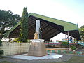 Rizal Monument and the Covered Court
 -
 Covered Court
 -
 Aguilar Catholic School, Inc.
 -
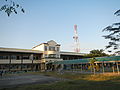
 Public Market and stores
 -
 Don Francisco Q. Duque Freedom Park
 -
 Aguilar Hospital


References
- ^ "Official City/Municipal 2013 Election Results". Intramuros, Manila, Philippines: Commission on Elections (COMELEC). 1 July 2013. Retrieved 3 September 2013.
- ^ a b "Province: PANGASINAN". PSGC Interactive. Makati City, Philippines: National Statistical Coordination Board. Archived from the original on 14 November 2012. Retrieved 26 November 2012.
{{cite web}}: Unknown parameter|deadurl=ignored (|url-status=suggested) (help) - ^ a b Census of Population (2020). "Region I (Ilocos Region)". Total Population by Province, City, Municipality and Barangay. Philippine Statistics Authority. Retrieved 8 July 2021.
- ^ "Pangasinan : Cities and Municipalities Competitiveness Index". Makati City, Philippines: National Competitiveness Council (Philippines). Archived from the original on 28 January 2017. Retrieved 28 January 2017.
{{cite web}}: Unknown parameter|deadurl=ignored (|url-status=suggested) (help) - ^ "PSA Releases the 2012 Municipal and City Level Poverty Estimates". Quezon City, Philippines: Philippine Statistics Authority. Archived from the original on 28 January 2017. Retrieved 28 January 2017.
{{cite web}}: Unknown parameter|deadurl=ignored (|url-status=suggested) (help) - ^ Aguilar. The Official Website of the Province of Pangasinan and its People. Retrieved April 9, 2012
- ^ Census of Population (2015). "Region I (Ilocos Region)". Total Population by Province, City, Municipality and Barangay. Philippine Statistics Authority. Retrieved 20 June 2016.
- ^ Census of Population and Housing (2010). "Region I (Ilocos Region)" (PDF). Total Population by Province, City, Municipality and Barangay. National Statistics Office. Retrieved 29 June 2016.
- ^ Censuses of Population (1903–2007). "Region I (Ilocos Region)". Table 1. Population Enumerated in Various Censuses by Province/Highly Urbanized City: 1903 to 2007. National Statistics Office.
- ^ "Province of Pangasinan". Municipality Population Data. Local Water Utilities Administration Research Division. Retrieved 17 December 2016.
- ^ "Aguilar, Pangasinan: Average Temperatures and Rainfall". World Weather Online. Retrieved 23 September 2015.
External links
- Municipal Profile at the National Competitiveness Council of the Philippines
- Aguilar at the Pangasinan Government Website
- Local Governance Performance Management System
- Philippine Standard Geographic Code
- Philippine Census Information
- Pangasinan.org : Aguilar Family and School Reunion Archives
Places adjacent to Aguilar, Pangasinan | |
|---|---|
| Municipalities |
|
|---|---|
| Component cities | |
| Independent component city |
|
| Barangays | |