
Bay Ridge Avenue station: Difference between revisions
Epicgenius (talk | contribs) Undid revision 789520510 by 173.3.52.74 (talk): it's closed |
Rescuing 1 sources and tagging 0 as dead. #IABot (v1.4.2) |
||
| Line 89: | Line 89: | ||
== External links == |
== External links == |
||
* {{NYCS ref|http://www.nycsubway.org/perl/stations?216:625|BMT 4th Avenue Line|Bay Ridge Avenue}} |
* {{NYCS ref|http://www.nycsubway.org/perl/stations?216:625|BMT 4th Avenue Line|Bay Ridge Avenue}} |
||
* Station Reporter — [http://www.stationreporter.net/rtrain.htm R Train] |
* Station Reporter — [https://web.archive.org/web/20080608075315/http://www.stationreporter.net/rtrain.htm R Train] |
||
* The Subway Nut — [http://www.subwaynut.com/bmt/bay_ridger/index.php Bay Ridge Avenue Pictures] |
* The Subway Nut — [http://www.subwaynut.com/bmt/bay_ridger/index.php Bay Ridge Avenue Pictures] |
||
* [https://maps.google.com/?ie=UTF8&ll=40.634628,-74.023519&spn=0.004038,0.013433&z=17&layer=c&cbll=40.634738,-74.023469&panoid=3LTcBn-D7-mc9wKGYPK3bg&cbp=12,338.04,,0,4.21 Bay Ridge Avenue entrance from Google Maps Street View] |
* [https://maps.google.com/?ie=UTF8&ll=40.634628,-74.023519&spn=0.004038,0.013433&z=17&layer=c&cbll=40.634738,-74.023469&panoid=3LTcBn-D7-mc9wKGYPK3bg&cbp=12,338.04,,0,4.21 Bay Ridge Avenue entrance from Google Maps Street View] |
||
Revision as of 10:42, 16 July 2017
Bay Ridge Avenue temporarily closed for construction | |||||||
|---|---|---|---|---|---|---|---|
 Manhattan-bound platform | |||||||
| Station statistics | |||||||
| Address | Bay Ridge Avenue & Fourth Avenue Brooklyn, NY 11220 | ||||||
| Borough | Brooklyn | ||||||
| Locale | Bay Ridge | ||||||
| Coordinates | 40°38′1.24″N 74°1′25.87″W / 40.6336778°N 74.0238528°W | ||||||
| Division | B (BMT)[1] | ||||||
| Line | BMT Fourth Avenue Line | ||||||
| Services | temporarily closed for construction | ||||||
| Transit | |||||||
| Structure | Underground | ||||||
| Platforms | 2 side platforms | ||||||
| Tracks | 2 | ||||||
| Other information | |||||||
| Opened | January 15, 1916[2] | ||||||
| Rebuilt | April 29, 2017 to October 2017 | ||||||
| Opposite- direction transfer | Yes | ||||||
| Traffic | |||||||
| 2023 | 1,784,703[3] | ||||||
| Rank | 178 out of 423[3] | ||||||
| Station succession | |||||||
| Next north | Template:NYCS next | ||||||
| Next south | Template:NYCS next | ||||||
| |||||||
| |||||||
| |||||||


Bay Ridge Avenue is a station on the BMT Fourth Avenue Line of the New York City Subway, located at the intersection of Bay Ridge Avenue and Fourth Avenue in Bay Ridge, Brooklyn. It is temporarily closed from April to October 2017, but under its normal service pattern is served by the R train at all times.[5]
History
This station opened on January 15, 1916 as part of an extension of the BMT Fourth Avenue Line from 59th Street to 86th Street.[2][6]
Station renovation
Under the 2015–2019 MTA Capital Plan, the station, along with thirty other New York City Subway stations, will undergo a complete overhaul and would be entirely closed for up to six months. Updates would include cellular service, Wi-Fi, charging stations, improved signage, and improved station lighting.[7][8] From January to May 2016, Grimshaw Architects worked on a design for the station's renovation, with Arup Group acting as a consultant. The award for Package 1 of the renovations, which will cover renovations at the Prospect Avenue, 53rd Street, and Bay Ridge Avenue stations on the BMT Fourth Avenue Line, was awarded on November 30, 2016.[9] The station is closed on April 29, 2017 for these renovations and is expected to reopen in October 2017.[10][11]
Station layout
| G | Street Level | Exit/Entrance |
| B1 | Mezzanine | Fare control, station agent |
| B2 | Side platform, not in service | |
| Northbound | ← | |
| Southbound | → | |
| Side platform, not in service | ||

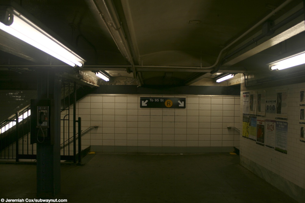
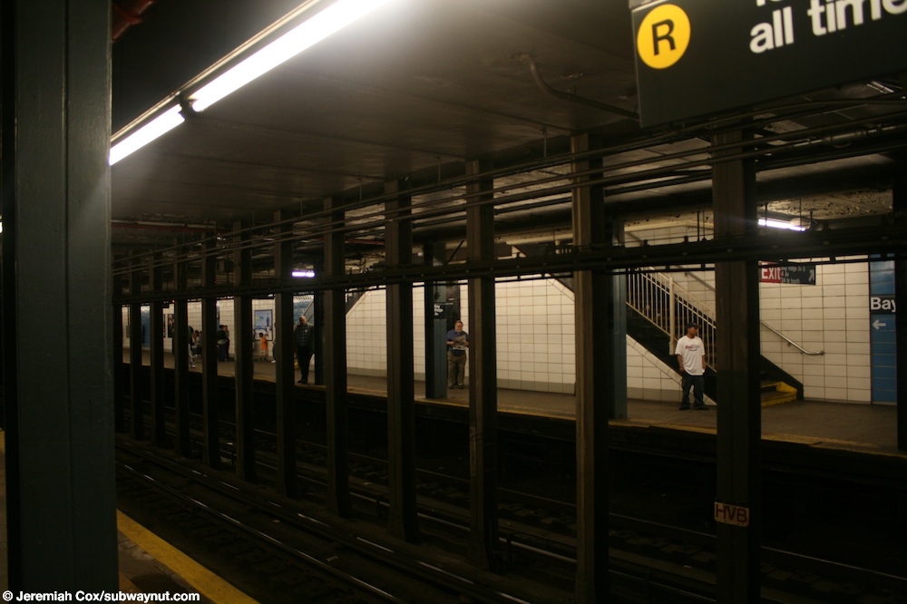
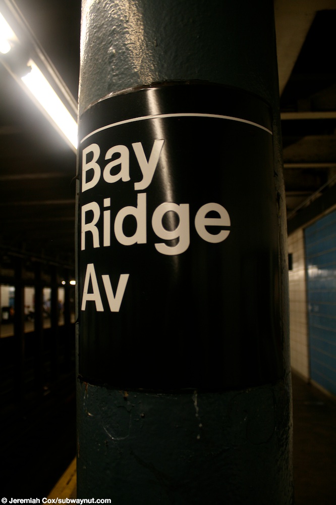
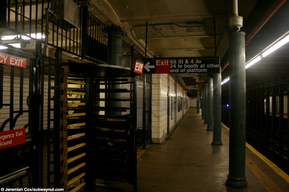
This underground station has two tracks and two side platforms.[12] The station's mezzanine is above the platforms with two staircases leading to each.[13][14] Only the 95th Street-bound platform has columns, except for the extreme ends of the platform, which have no columns.[15] All of the columns are painted blue and are standard I-beams. All columns have "Bay Ridge Av" signs on them.[16]
There is space for an additional trackway under the northbound platform. The station is built on the west side of Fourth Avenue due to plans for a possible extension of the express tracks south of 59th Street.[17] As a result of the possibility of the extension of the express tracks, there is space underneath the northbound platform for an additional trackway at this station for the Bay Ridge-bound express track. This also can be found at 77th Street. Further evidence of the provisions for tracks on the east side of Fourth Avenue can be seen north of this station, where the subway is carried in the lower deck of a bridge (Fourth Avenue) over the LIRR Bay Ridge Branch cut.[18] On this cut it can be seen that the bridge has four trackways of which only the western two are used. The tunnel leading up to each side of the bridge was built for two tracks only.[19][20] Daylight can briefly be seen from the bridge.[21]
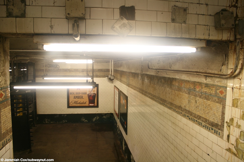
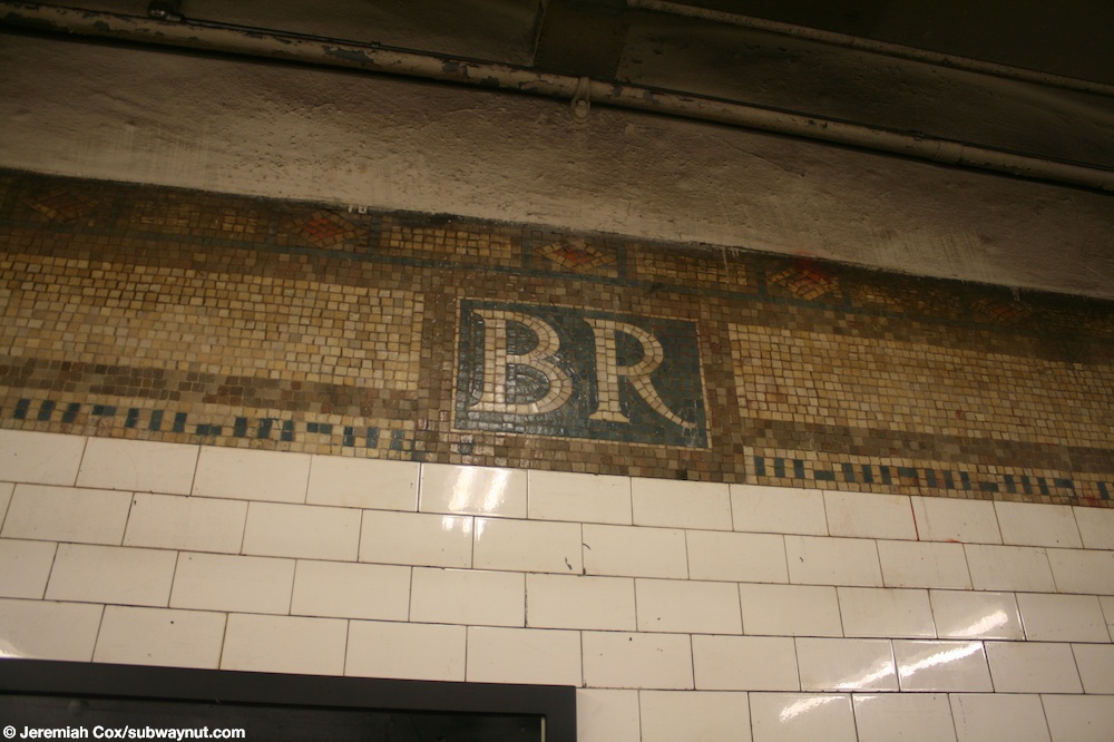
This station was overhauled in the late 1970s, which included fixing the station's structure and overall appearance. The original trim lines were replaced with gray and blue cinderblock tiles. The staircases were repaired and new platform edges were installed. The blue cinderblock field contains the station signs and white text pointing to the exits. The landing in the southbound platform's exit-only is the only area in the station that contains the original 1915 trim line with "B.R." tiled on it.[22][23]
Exits
From the mezzanine outside of fare control, two staircases lead to either southern corners of Bay Ridge and Fourth Avenues.[24] The 95th Street-bound platform has an additional exit-only near the north end; a single-platform level turnstile leads to a small landing, where a double-flight staircase goes up to the northwest corner of 68th Street and Fourth Avenue.[25][26]
References
- ^ "Glossary". Second Avenue Subway Supplemental Draft Environmental Impact Statement (SDEIS) (PDF). Vol. 1. Metropolitan Transportation Authority. March 4, 2003. pp. 1–2. Archived from the original (PDF) on February 26, 2021. Retrieved January 1, 2021.
- ^ a b "Subway Running To Eighty-Sixth Street Starts Building Boom In Bay Ridge". Brooklyn Daily Eagle. January 15, 1916. Retrieved June 29, 2015 – via Newspapers.com.
- ^ a b "Annual Subway Ridership (2018–2023)". Metropolitan Transportation Authority. 2023. Retrieved April 20, 2024.
- ^ "Annual Subway Ridership (2018–2023)". Metropolitan Transportation Authority. 2023. Retrieved April 20, 2024.
- ^ "R Train Timetable Subway Timetable January 1, 2017" (PDF). mta.info. Metropolitan Transportation Authority. January 1, 2017. Retrieved March 26, 2017.
{{cite web}}: Cite has empty unknown parameter:|dead-url=(help) - ^ Senate, New York (State) Legislature (January 1, 1917). Documents of the Senate of the State of New York.
- ^ "MTA Will Completely Close 30 Subway Stations For Months-Long "Revamp"". Gothamist. Retrieved July 18, 2016.
- ^ "MTAStations" (PDF). governor.ny.gov. Government of the State of New York. Retrieved July 18, 2016.
- ^ "Capital Program Oversight Committee Meeting" (PDF). mta.info. Metropolitan Transportation Authority. November 2016. Retrieved November 27, 2016.
- ^ Spivack, Caroline (January 16, 2017). "Shuttle scuttle: Riders demand extra buses during three subway stations' closure". Brooklyn Paper. Retrieved January 27, 2017.
- ^ "MTA will close these Brooklyn subway stops to facilitate upgrades". Curbed NY. March 22, 2017. Retrieved March 24, 2017.
- ^ Dougherty, Peter (2006) [2002]. Tracks of the New York City Subway 2006 (3rd ed.). Dougherty. OCLC 49777633 – via Google Books.
- ^ Cox, Jeremiah (June 9, 2009). "Looking towards a boring 1970s cinderblocked wall and the two staircases down to the 95 St-bound platform at Bay Ridge Avenue". subwaynut.com. Retrieved March 30, 2017.
{{cite web}}: Cite has empty unknown parameter:|dead-url=(help) - ^ Cox, Jeremiah (June 9, 2009). "Looking across to the Manhattan-bound platform with the two staircases that lead up to the mezzanine at Bay Ridge Avenue visible". subwaynut.com. Retrieved March 30, 2017.
{{cite web}}: Cite has empty unknown parameter:|dead-url=(help) - ^ Cox, Jeremiah (June 9, 2009). "Looking across the tracks to the columnless Manhattan-bound platform at Bay Ridge Av". subwaynut.com. Retrieved March 30, 2017.
{{cite web}}: Cite has empty unknown parameter:|dead-url=(help) - ^ Cox, Jeremiah (June 9, 2009). "A close up of a Bay Ridge Av column sign". subwaynut.com. Retrieved March 30, 2017.
{{cite web}}: Cite has empty unknown parameter:|dead-url=(help) - ^ "Brooklyn Subway Extension Plan: Fourth Ave. Line to 86th St., Tunnel to Staten Island, and Eventually a Through Route to Coney Island". nytimes.com. The New York Times. February 16, 1912. Retrieved June 28, 2015.
- ^ Video on YouTube
- ^ Anastasio, Joe (June 12, 2006). "The Ridge Bridge". LTV Squad. Retrieved March 30, 2017.
{{cite web}}: Cite has empty unknown parameter:|dead-url=(help) - ^ "www.nycsubway.org: BMT 4th Avenue Line". www.nycsubway.org. Retrieved March 30, 2017.
{{cite web}}: Cite has empty unknown parameter:|dead-url=(help) - ^ "Bay Ridge Bridge". Photobucket. 2006. Retrieved March 30, 2017.
{{cite web}}: Cite has empty unknown parameter:|dead-url=(help) - ^ Cox, Jeremiah (June 9, 2009). "A view of almost all of the trim-line left on the Brooklyn-bound platform, outside of fare control at the 68 Street exit at Bay Ridge Avenue". subwaynut.com. Retrieved March 30, 2017.
{{cite web}}: Cite has empty unknown parameter:|dead-url=(help) - ^ Cox, Jeremiah (June 9, 2009). "A close up of the letters BR in the platform's only intact trim area, on the outside area of the High Exit Turnstile exit only exit to 68 St at Bay Ridge Avenue". subwaynut.com. Retrieved March 30, 2017.
{{cite web}}: Cite has empty unknown parameter:|dead-url=(help) - ^ Cox, Jeremiah (June 9, 2009). "One of the two entrance staircases to Bay Ridge Avenue, down to the station's small mezzanine area". subwaynut.com. Retrieved March 30, 2017.
{{cite web}}: Cite has empty unknown parameter:|dead-url=(help) - ^ Cox, Jeremiah (June 9, 2009). "Approaching the High Exit gate exit to 68 St & 4 Avenue at Bay Ridge Avenue". subwaynut.com. Retrieved March 30, 2017.
{{cite web}}: Cite has empty unknown parameter:|dead-url=(help) - ^ "MTA Neighborhood Maps: Bay Ridge" (PDF). mta.info. Metropolitan Transportation Authority. 2015. Retrieved August 2, 2015.
External links
- nycsubway.org – BMT 4th Avenue Line: Bay Ridge Avenue
- Station Reporter — R Train
- The Subway Nut — Bay Ridge Avenue Pictures
- Bay Ridge Avenue entrance from Google Maps Street View
- 68th Street exit only stairs from Google Maps Street View
- Platforms from Google Maps Street View