
Bear Mountain Bridge: Difference between revisions
category refine |
Rescuing 2 sources and tagging 0 as dead. #IABot (v1.4.2) |
||
| Line 16: | Line 16: | ||
|clearance = |
|clearance = |
||
|below = {{convert|155|ft|m}} |
|below = {{convert|155|ft|m}} |
||
|traffic = 17,695 (2007)<ref>{{cite web |url=https://www.dot.ny.gov/divisions/engineering/technical-services/hds-respository/Traffic%20Data%20Report%202010%20Appendix%20C%20-%20AADT%20Values%20for%20Select%20Toll%20Facilities.pdf|title=2008 Traffic Data Report for New York State |format=PDF |publisher=[[New York State Department of Transportation]] |at=Appendix C |accessdate=February 27, 2010}}</ref> |
|traffic = 17,695 (2007)<ref>{{cite web |url=https://www.dot.ny.gov/divisions/engineering/technical-services/hds-respository/Traffic%20Data%20Report%202010%20Appendix%20C%20-%20AADT%20Values%20for%20Select%20Toll%20Facilities.pdf |title=2008 Traffic Data Report for New York State |format=PDF |publisher=[[New York State Department of Transportation]] |at=Appendix C |accessdate=February 27, 2010 |deadurl=yes |archiveurl=https://web.archive.org/web/20120927023745/https://www.dot.ny.gov/divisions/engineering/technical-services/hds-respository/Traffic%20Data%20Report%202010%20Appendix%20C%20-%20AADT%20Values%20for%20Select%20Toll%20Facilities.pdf |archivedate=September 27, 2012 |df= }}</ref> |
||
|open = 1924 |
|open = 1924 |
||
|toll = Cars $1.50 (eastbound) |
|toll = Cars $1.50 (eastbound) |
||
| Line 115: | Line 115: | ||
==External links== |
==External links== |
||
{{commons category|Bear Mountain Bridge}} |
{{commons category|Bear Mountain Bridge}} |
||
*[https://web.archive.org/web/20090110004020/http://www.nysba.state.ny.us |
*[https://web.archive.org/web/20090110004020/http://www.nysba.state.ny.us/bridgepages/BMB/BMBpage/bmb_page.htm New York State Bridge Authority site] |
||
*[http://www.nycroads.com/crossings/bear-mountain/ Bear Mountain Bridge at nycroads.com] |
*[http://www.nycroads.com/crossings/bear-mountain/ Bear Mountain Bridge at nycroads.com] |
||
*[http://www.bridgemeister.com/bridge.php?bid=141 Bear Mountain Bridge at bridgemeister.com] |
*[http://www.bridgemeister.com/bridge.php?bid=141 Bear Mountain Bridge at bridgemeister.com] |
||
Revision as of 16:36, 16 July 2017
Bear Mountain Bridge | |
|---|---|
 Bear Mountain Bridge in 2009 | |
| Coordinates | 41°19′12″N 73°58′49″W / 41.32°N 73.9803°W |
| Carries | 2 lanes of |
| Crosses | Hudson River |
| Locale | Cortlandt / Stony Point, NW of Peekskill, NY |
| Maintained by | New York State Bridge Authority |
| Characteristics | |
| Design | Suspension bridge |
| Total length | 2,255 feet (687 m) |
| Width | 48 feet (15 m) |
| Height | 360 feet (110 m) |
| Longest span | 1,632 feet (497 m)[1] |
| Clearance below | 155 feet (47 m) |
| History | |
| Opened | 1924 |
| Statistics | |
| Daily traffic | 17,695 (2007)[2] |
| Toll | Cars $1.50 (eastbound) |
Bear Mountain Bridge | |
  | |
| Location | Stony Point, New York |
| Coordinates | 41°19′12″N 73°58′49″W / 41.32000°N 73.98028°W |
| Built | 1923 |
| Architect | Baird, Howard C.; Terr & Tench Construction Co. |
| MPS | Hudson Highlands MRA |
| NRHP reference No. | 82001266 |
| Added to NRHP | November 23, 1982[3] |
| Location | |
 | |
The Bear Mountain Bridge is a toll suspension bridge in New York State, carrying US 6/US 202 across the Hudson River between Rockland/Orange Counties and Westchester/Putnam Counties. From the time of its completion in 1924, it held the record for the longest suspension bridge in the world for 19 months, until it was surpassed by the Benjamin Franklin Bridge in Philadelphia.
The span enables connections to the Palisades Interstate Parkway and US 9W on the west bank near Bear Mountain Inn to New York State Route 9D (NY 9D) on the east. It also carries the Appalachian Trail and New York State Bicycle Route 9 across the Hudson.
The bridge has two lanes (one west, one east), separated by a dividing double yellow line. The span includes pedestrian walkways on both sides of the bridge. Bicycling is legal on the roadway. Cyclists may walk their cycles on the pedestrian walkway.
History
Hudson Highland Suspension Bridge
Plans for a bridge at the site had been made as early as 1868. The following year, The New York Times reported that a contract had been signed and construction would "speedily commence" on the "Hudson Highland Suspension Bridge" between Fort Clinton and Anthony's Nose. The intent was to carry a railroad toward Derby, Connecticut, to supply coal and iron for industry in the lower Naugatuck Valley. The surface of the bridge was to be 150 feet (46 m) above high tide. In 1871 the newspaper reported that capital of $2.5 million had been raised and construction was expected to begin in 1875.
In 1887, reports said the bridge would be finished in two years. By 1889, "work on the anchor pits was progressing rapidly."[4]
The story again resurfaces in 1896, when the Hudson Highland Bridge and Railway Company reportedly filed for incorporation with capital of $84,900. The company was described as a reorganization of the former Hudson Suspension Bridge and New England Railway Company, which at some point included steel magnate Andrew Carnegie on its board.
Much of this period coincided with the so-called Long Depression, including stock market crashes called the Panic of 1873 and Panic of 1893. A charter for construction of the bridge expired in 1916.[5]
Bear Mountain Hudson River Bridge Company
In March 1922, the state Legislature authorized creation of the private Bear Mountain Hudson River Bridge Company to complete the project, including a 3-mile (4.8 km) approach road from the Albany Post Road north of Peekskill. The 11-member board of directors included financiers E. Roland Harriman and George W. Perkins. A $4.5 million bond issue was completed in April of that year through the Harriman banking and brokerage firm. Under the 1922 charter, ownership of the bridge was to revert by 1962 from the bridge company to New York State, which also had the right to acquire the bridge at any time.[6]
Completion
When the bridge formally opened on November 27, 1924, it was the longest suspension bridge span in the world, and the first of its type to have a concrete deck. It was the first automobile bridge to cross the Hudson south of Albany and surpassed the 1888 Poughkeepsie Railroad Bridge as the southernmost crossing of the river.[7][8]
Construction methods pioneered on the Bear Mountain Bridge influenced much larger projects to follow, including the George Washington (1931) and Golden Gate (1937) bridges. Completion also inspired the state to extend the Bronx River Parkway from Kensico Dam northward, work which evolved into the Bear Mountain Parkway and the first phase of the Taconic State Parkway.
New York State Bridge Authority
Ownership was transferred to the New York State Bridge Authority on September 26, 1940 and the toll was reduced to a flat rate of 50 cents per automobile.[9][10] In 1982 the bridge and its then-abandoned original toll house several miles away on the Peekskill approach road, Routes 6 and 202, were added to the National Register of Historic Places.[3] The bridge was also designated as a local historic civil engineering landmark by the American Society of Civil Engineers in 1986.[11]
Since January 30, 2012, the automobile toll has been $1.50 for those paying cash, and is collected from eastbound travelers only.[12]
Maintenance innovation
The Bear Mountain Bridge was used to develop and test a new material designed to lower the cost and environmental impact of bridge cable maintenance. For over 100 years, a red lead paste material was used to seal the strands of bridge cables to prevent moisture intrusion. The lead-based material, an environmental hazard, was also prone to drying out and cracking in a few years.
During routine inspections, bridge cables are unwrapped and wedges are used to separate the individual strands. Inspectors look for signs of moisture and corrosion throughout the cable. In the 1990s engineers experimented with several materials on a small section of the cables of the Bear Mountain Bridge. After a year the test areas were reexamined and one polymer-based, non-toxic paste material was found to be superior. The bridge cables were then rewrapped in 2000 using the material. The cables were found to be free of additional moisture or corrosion in a 2007 inspection. New York State Bridge Authority chief engineer William Moreau is hopeful that the new material will lengthen the life of the cables, and lower the need for inspection and maintenance.[8]
Gallery
-
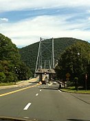
 Heading westbound over the bridge
 -
 View from the river looking east
 -
 Looking northwest from the east bank
 -
 Old Bear Mountain Bridge Toll House along Routes 6 and 202, between the bridge and Peekskill, today used as an information center for surrounding parkland
 -
 The Bear Mountain Bridge EZ Pass Toll


See also
 New York portal
 National Register of Historic Places portal
- List of fixed crossings of the Hudson River
- List of bridges and tunnels on the National Register of Historic Places in New York
- National Register of Historic Places listings in Rockland County, New York
- National Register of Historic Places listings in northern Westchester County, New York
References
- Sources
- Notes
- ^ Guide to Civil Engineering Projects In and Around New York City (2nd ed.). Metropolitan Section, American Society of Civil Engineers. 2009. p. 31.
- ^ "2008 Traffic Data Report for New York State" (PDF). New York State Department of Transportation. Appendix C. Archived from the original (PDF) on September 27, 2012. Retrieved February 27, 2010.
{{cite web}}: Unknown parameter|deadurl=ignored (|url-status=suggested) (help) - ^ a b "National Register Information System". National Register of Historic Places. National Park Service. April 15, 2008.
- ^ "The Anthony Nose Bridge.; Work on the Anchor Pits Progressing Rapidly". The New York Times. September 4, 1889. p. 3. Retrieved February 13, 2010.
- ^ "New Scenic Motor Highway in Highlands of the Hudson". The New York Times. May 6, 1923. p. XX6. Retrieved February 13, 2010.
- ^ "Would Span Hudson at Bear Mountain". The New York Times. February 9, 1922. p. 27. Retrieved February 13, 2010.
- ^ "Open New Bridge Over Hudson River". The New York Times. November 27, 1924. p. 21. Retrieved March 27, 2010.
- ^ a b "Sticky solution". Bridge Design & Engineering. May 25, 2008. Archived from the original on 28 August 2008. Retrieved August 13, 2008.
{{cite web}}: Unknown parameter|deadurl=ignored (|url-status=suggested) (help) - ^ "State Recaptures Bear Mt Bridge". The New York Times. August 8, 1940. p. 21. Retrieved February 13, 2010.
- ^ "State Will Take Over Bear Mt. Span Today". The New York Times. September 25, 1940. p. 21. Retrieved March 27, 2010.
- ^ "Bear Mountain Bridge". ASCE Metropolitan Section. Retrieved November 12, 2016.
- ^ "Toll Rate History". New York State Bridge Authority. Archived from the original on 2015-10-21.
External links
- New York State Bridge Authority site
- Bear Mountain Bridge at nycroads.com
- Bear Mountain Bridge at bridgemeister.com
Crossings of the Hudson River | ||||
|---|---|---|---|---|
| ||||
| Topics | |
|---|---|
| Lists by state |
|
| Lists by insular areas | |
| Lists by associated state | |
| Other areas | |
| Related | |
- Bridges over the Hudson River
- Toll bridges in New York
- Suspension bridges in New York
- Bridges completed in 1924
- U.S. Route 6
- U.S. Route 202
- Road bridges on the National Register of Historic Places in New York
- National Register of Historic Places in Westchester County, New York
- New York State Bridge Authority
- Transportation in Rockland County, New York
- Buildings and structures in Rockland County, New York
- Road bridges in New York
- 1924 establishments in New York
- Bridges on the United States Numbered Highways