
Commonwealth Avenue (Boston): Difference between revisions
m →Statuary: cite wikisource/interim to cite wikisource; see template talk; cleanup; |
BenjaminR44 (talk | contribs) mNo edit summary |
||
| Line 6: | Line 6: | ||
==Description== |
==Description== |
||
Often compared to [[Georges-Eugène Haussmann|Georges-Eugène Haussmann's]] Paris boulevards, Commonwealth Avenue in Back Bay is a [[parkway]] divided at center by a wide grassy mall. |
Often compared to [[Georges-Eugène Haussmann|Georges-Eugène Haussmann's]] Paris boulevards, Commonwealth Avenue in Back Bay is a [[parkway]] divided at center by a wide grassy mall. This [[greenway (landscape)|greenway]], called '''Commonwealth Avenue Mall''', is punctuated with statuary and memorials, and forms the narrowest "link" in the [[Emerald Necklace]]. It connects the [[Public Garden (Boston, Massachusetts)|Public Garden]] to [[Back Bay Fens|the Fens]]. |
||
Where Commonwealth Avenue reaches [[Kenmore Square]], the [[MBTA]] [[Green Line (MBTA)|Green Line]] [[Green Line "B" Branch|"B" Branch]] rises above ground and dominates the center of the roadway through the campus of [[Boston University]] and the neighborhoods of [[Allston, Massachusetts|Allston]] and [[Brighton, Massachusetts|Brighton]] to the city of [[Newton, Massachusetts|Newton]] near [[Boston College]]. |
Where Commonwealth Avenue reaches [[Kenmore Square]], the [[MBTA]] [[Green Line (MBTA)|Green Line]] [[Green Line "B" Branch|"B" Branch]] rises above ground and dominates the center of the roadway through the campus of [[Boston University]] and the neighborhoods of [[Allston, Massachusetts|Allston]] and [[Brighton, Massachusetts|Brighton]] to the city of [[Newton, Massachusetts|Newton]] near [[Boston College]]. The section in Newton is made up of two roadways separated by a grassy median lined with trees. The south side of the roadway contains the main, two-lane east-west roadway, with a one-way, westbound "carriage road" providing local access on the north side of the median. |
||
The linear {{convert|1.5|mi|km}} stretch of Commonwealth Avenue between Kenmore Square and [[Packard's Corner]] (where Brighton Avenue maintains a straight continuum and Commonwealth Avenue splits off) is well known to be Boston University territory. Boston University owns much of the property along and around this part of Commonwealth Avenue and either rents it out or uses it for its own purposes. This 1.5-mile stretch is the most central route to commuting around Boston University's main campus, also known as the Charles River Campus, and is frequented by pedestrians, cars, motorcycles, vespas, bikes, skateboards, scooters, both the inbound and outbound MBTA Green Line "B" Branch trains (running above ground), both the inbound and outbound MBTA #57 & #57A buses, the Boston University Shuttle, charter buses, and trucks alike. Walking from one end (Kenmore Square) to the other end (Packard's Corner) or vice versa takes about 25–35 minutes. There are nine MBTA Green Line "B" Branch stops between Kenmore Square and Packard's Corner (inclusive) within these 1.5 miles and they are very commonly used for transportation from one end of campus to the other, and beyond. Moving farther from the city and closer to the outskirts and the suburbs, the Kenmore Square stop is followed by Blandford Street, Boston University East, Boston University Central, Boston University West, St. Paul Street, Pleasant Street, Babcock Street, and Packard's Corner. Together, these nine stops are renowned for representing Boston University's presence in and around this 1.5-mile stretch of Commonwealth Avenue. In addition, a majority of the BU student body, which consists of approximately 33,000 enrolled undergraduate and graduate students,<ref>{{cite web|url=http://colleges.usnews.rankingsandreviews.com/best-colleges/boston-university-2130|title=Boston University|work=rankingsandreviews.com}}</ref> resides alongside these stops, creating a particular neighborhood that identifies this area. |
The linear {{convert|1.5|mi|km}} stretch of Commonwealth Avenue between Kenmore Square and [[Packard's Corner]] (where Brighton Avenue maintains a straight continuum and Commonwealth Avenue splits off) is well known to be Boston University territory. Boston University owns much of the property along and around this part of Commonwealth Avenue and either rents it out or uses it for its own purposes. This 1.5-mile stretch is the most central route to commuting around Boston University's main campus, also known as the Charles River Campus, and is frequented by pedestrians, cars, motorcycles, vespas, bikes, skateboards, scooters, both the inbound and outbound MBTA Green Line "B" Branch trains (running above ground), both the inbound and outbound MBTA #57 & #57A buses, the Boston University Shuttle, charter buses, and trucks alike. Walking from one end (Kenmore Square) to the other end (Packard's Corner) or vice versa takes about 25–35 minutes. There are nine MBTA Green Line "B" Branch stops between Kenmore Square and Packard's Corner (inclusive) within these 1.5 miles and they are very commonly used for transportation from one end of campus to the other, and beyond. Moving farther from the city and closer to the outskirts and the suburbs, the Kenmore Square stop is followed by Blandford Street, Boston University East, Boston University Central, Boston University West, St. Paul Street, Pleasant Street, Babcock Street, and Packard's Corner. Together, these nine stops are renowned for representing Boston University's presence in and around this 1.5-mile stretch of Commonwealth Avenue. In addition, a majority of the BU student body, which consists of approximately 33,000 enrolled undergraduate and graduate students,<ref>{{cite web|url=http://colleges.usnews.rankingsandreviews.com/best-colleges/boston-university-2130|title=Boston University|work=rankingsandreviews.com}}</ref> resides alongside these stops, creating a particular neighborhood that identifies this area. |
||
| Line 15: | Line 15: | ||
The Commonwealth Avenue Mall was designed by [[Arthur Gilman|Arthur Delevan Gilman]].<ref>[http://www.nabbonline.com/commonwealth_mall.htm Neighborhood Association of the Back Bay - Commonwealth Mall<!-- Bot generated title -->] {{webarchive|url=https://web.archive.org/web/20070311090440/http://www.nabbonline.com/commonwealth_mall.htm |date=2007-03-11 }}</ref> [[Frederick Law Olmsted]] designed the Newton portion of Commonwealth Ave and included the parkway as part of the Emerald Necklace park system. The first statue on the Commonwealth Avenue Mall was erected in 1865 at Arlington Street.<ref>[http://www.nabbonline.com/statues.htm NABB - Comm Ave. Mall Statues: What's In A Name?<!-- Bot generated title -->] {{webarchive|url=https://web.archive.org/web/20060716171640/http://www.nabbonline.com/statues.htm |date=2006-07-16 }}</ref> |
The Commonwealth Avenue Mall was designed by [[Arthur Gilman|Arthur Delevan Gilman]].<ref>[http://www.nabbonline.com/commonwealth_mall.htm Neighborhood Association of the Back Bay - Commonwealth Mall<!-- Bot generated title -->] {{webarchive|url=https://web.archive.org/web/20070311090440/http://www.nabbonline.com/commonwealth_mall.htm |date=2007-03-11 }}</ref> [[Frederick Law Olmsted]] designed the Newton portion of Commonwealth Ave and included the parkway as part of the Emerald Necklace park system. The first statue on the Commonwealth Avenue Mall was erected in 1865 at Arlington Street.<ref>[http://www.nabbonline.com/statues.htm NABB - Comm Ave. Mall Statues: What's In A Name?<!-- Bot generated title -->] {{webarchive|url=https://web.archive.org/web/20060716171640/http://www.nabbonline.com/statues.htm |date=2006-07-16 }}</ref> |
||
The Newton end of the roadway was constructed in 1895 with a line of the [[Middlesex and Boston Street Railway]] in the median. [[Streetcar]] service was cut back to its present terminus at the Boston border in 1930 and [[buses]] last ran on Commonwealth Avenue in 1976. An [[amusement park]] and [[ballroom]] known as [[Norumbega Park]] was built at the end of the line on the Charles River in 1897 to increase streetcar patronage.<ref>[http://users.rcn.com/ralphjohn/aca/norumbega/norumbega.html Auburndale Community Association page on Norumbega Park]</ref> |
The Newton end of the roadway was constructed in 1895 with a line of the [[Middlesex and Boston Street Railway]] in the median. [[Streetcar]] service was cut back to its present terminus at the Boston border in 1930 and [[buses]] last ran on Commonwealth Avenue in 1976. An [[amusement park]] and [[ballroom]] known as [[Norumbega Park]] was built at the end of the line on the Charles River in 1897 to increase streetcar patronage.<ref>[http://users.rcn.com/ralphjohn/aca/norumbega/norumbega.html Auburndale Community Association page on Norumbega Park]</ref> The eastern half of the Newton section of the road is listed on the [[National Register of Historic Places]] as the [[Commonwealth Avenue Historic District (Newton, Massachusetts)|Commonwealth Avenue Historic District]]. The mall that includes the landscape features, monuments, street furniture and fences that are bounded by Kenmore Street, Arlington Street and Commonwealth Avenue was designated as a [[Boston Landmark]] by the [[Boston Landmarks Commission]] in 1977. |
||
==Statuary== |
==Statuary== |
||
| Line 28: | Line 28: | ||
* The [[Boston Women's Memorial]], with statues of [[Abigail Adams]], [[Lucy Stone]], and [[Phillis Wheatley]], sculpted by [[Meredith Bergmann]]. 2003. |
* The [[Boston Women's Memorial]], with statues of [[Abigail Adams]], [[Lucy Stone]], and [[Phillis Wheatley]], sculpted by [[Meredith Bergmann]]. 2003. |
||
* [[Domingo Sarmiento]], former president of [[Argentina]], sculpted by Yvette Compagnion. 1973. A gift of the Argentine government in 1913, the statue arrived in Boston sixty years later. |
* [[Domingo Sarmiento]], former president of [[Argentina]], sculpted by Yvette Compagnion. 1973. A gift of the Argentine government in 1913, the statue arrived in Boston sixty years later. |
||
* [[Leif Ericson]], first European discoverer of [[Newfoundland (island)|Newfoundland]], sculpted by [[Anne Whitney]]. 1887. Commissioned by [[Eben Norton Horsford]], the inventor of baking powder, this statue was originally sited at the [[Massachusetts Avenue (Boston)|Massachusetts Avenue]] end of this block, but was moved to Charlesgate in 1917. |
* [[Leif Ericson]], first European discoverer of [[Newfoundland (island)|Newfoundland]], sculpted by [[Anne Whitney]]. 1887. Commissioned by [[Eben Norton Horsford]], the inventor of baking powder, this statue was originally sited at the [[Massachusetts Avenue (Boston)|Massachusetts Avenue]] end of this block, but was moved to Charlesgate in 1917. [[Anne Whitney|Whitney]] also created a monument to [[Leif Ericson|Leif]] situated on the shores of Lake Michigan in Milwaukee.<ref>{{cite web|url=http://www.shorpy.com/node/23704|type=Dry Plate Glass Negative|location=The shores of Lake Michigan|date=c. 1899|title=Leif Erikson statue, Milwaukee, Wisconsin.|access-date=19 August 2018|work=[[Shorpy.com]]}}</ref><ref>{{cite wikisource |chapter=Whitney, Anne |wslink=The Encyclopedia Americana (1920) |plaintitle=The Encyclopedia Americana (1920)}}</ref> |
||
<gallery class="center" widths="200px" heights="175px"> |
<gallery class="center" widths="200px" heights="175px"> |
||
Revision as of 17:08, 18 March 2019


Commonwealth Avenue (colloquially referred to as Comm Ave by locals) is a major street in the cities of Boston and Newton, Massachusetts. It begins at the western edge of the Boston Public Garden, and continues west through the neighborhoods of the Back Bay, Kenmore Square, Allston, Brighton and Chestnut Hill. It continues as part of Route 30 through Newton until it crosses the Charles River at the border of the town of Weston.
Description
Often compared to Georges-Eugène Haussmann's Paris boulevards, Commonwealth Avenue in Back Bay is a parkway divided at center by a wide grassy mall. This greenway, called Commonwealth Avenue Mall, is punctuated with statuary and memorials, and forms the narrowest "link" in the Emerald Necklace. It connects the Public Garden to the Fens.
Where Commonwealth Avenue reaches Kenmore Square, the MBTA Green Line "B" Branch rises above ground and dominates the center of the roadway through the campus of Boston University and the neighborhoods of Allston and Brighton to the city of Newton near Boston College. The section in Newton is made up of two roadways separated by a grassy median lined with trees. The south side of the roadway contains the main, two-lane east-west roadway, with a one-way, westbound "carriage road" providing local access on the north side of the median.
The linear 1.5 miles (2.4 km) stretch of Commonwealth Avenue between Kenmore Square and Packard's Corner (where Brighton Avenue maintains a straight continuum and Commonwealth Avenue splits off) is well known to be Boston University territory. Boston University owns much of the property along and around this part of Commonwealth Avenue and either rents it out or uses it for its own purposes. This 1.5-mile stretch is the most central route to commuting around Boston University's main campus, also known as the Charles River Campus, and is frequented by pedestrians, cars, motorcycles, vespas, bikes, skateboards, scooters, both the inbound and outbound MBTA Green Line "B" Branch trains (running above ground), both the inbound and outbound MBTA #57 & #57A buses, the Boston University Shuttle, charter buses, and trucks alike. Walking from one end (Kenmore Square) to the other end (Packard's Corner) or vice versa takes about 25–35 minutes. There are nine MBTA Green Line "B" Branch stops between Kenmore Square and Packard's Corner (inclusive) within these 1.5 miles and they are very commonly used for transportation from one end of campus to the other, and beyond. Moving farther from the city and closer to the outskirts and the suburbs, the Kenmore Square stop is followed by Blandford Street, Boston University East, Boston University Central, Boston University West, St. Paul Street, Pleasant Street, Babcock Street, and Packard's Corner. Together, these nine stops are renowned for representing Boston University's presence in and around this 1.5-mile stretch of Commonwealth Avenue. In addition, a majority of the BU student body, which consists of approximately 33,000 enrolled undergraduate and graduate students,[1] resides alongside these stops, creating a particular neighborhood that identifies this area.
History
The Commonwealth Avenue Mall was designed by Arthur Delevan Gilman.[2] Frederick Law Olmsted designed the Newton portion of Commonwealth Ave and included the parkway as part of the Emerald Necklace park system. The first statue on the Commonwealth Avenue Mall was erected in 1865 at Arlington Street.[3]
The Newton end of the roadway was constructed in 1895 with a line of the Middlesex and Boston Street Railway in the median. Streetcar service was cut back to its present terminus at the Boston border in 1930 and buses last ran on Commonwealth Avenue in 1976. An amusement park and ballroom known as Norumbega Park was built at the end of the line on the Charles River in 1897 to increase streetcar patronage.[4] The eastern half of the Newton section of the road is listed on the National Register of Historic Places as the Commonwealth Avenue Historic District. The mall that includes the landscape features, monuments, street furniture and fences that are bounded by Kenmore Street, Arlington Street and Commonwealth Avenue was designated as a Boston Landmark by the Boston Landmarks Commission in 1977.
Statuary
Starting at the Public Garden and going westward, the following statues can be seen on the mall:
- Alexander Hamilton, co-author of The Federalist Papers, sculpted by William Rimmer. The first statue placed on the mall. 1865.
- John Glover, Revolutionary War soldier, sculpted by Martin Milmore. 1875.
- Patrick Andrew Collins, former mayor of Boston, sculpted by Henry Hudson Kitson and Theo Alice Ruggles Kitson. Moved in 1966 from its original siting at Charlesgate due to construction of the Bowker Overpass.
- The Vendome Memorial, which honors nine firefighters killed in the 1972 Hotel Vendome fire, sculpted by Theodore Clausen with landscape architect Peter White. 1997.
- William Lloyd Garrison, abolitionist and journalist, sculpted by Owen Levi Warner.
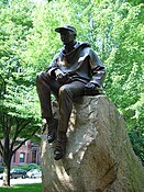
- Samuel Eliot Morison, naval historian and writer, sculpted by Penelope Jencks. 1982.
- The Boston Women's Memorial, with statues of Abigail Adams, Lucy Stone, and Phillis Wheatley, sculpted by Meredith Bergmann. 2003.
- Domingo Sarmiento, former president of Argentina, sculpted by Yvette Compagnion. 1973. A gift of the Argentine government in 1913, the statue arrived in Boston sixty years later.
- Leif Ericson, first European discoverer of Newfoundland, sculpted by Anne Whitney. 1887. Commissioned by Eben Norton Horsford, the inventor of baking powder, this statue was originally sited at the Massachusetts Avenue end of this block, but was moved to Charlesgate in 1917. Whitney also created a monument to Leif situated on the shores of Lake Michigan in Milwaukee.[5][6]
-
 Hamilton Statue, 19th century
 -
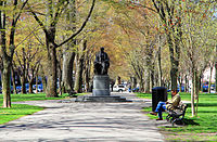
 Statue of Samuel Eliot Morison on the mall, 2006
 -
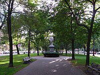 The Commonwealth Avenue Mall looking west towards the Alexander Hamilton statue, 2006


Gallery
-
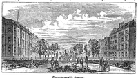
 c. 1881
 -
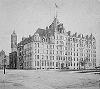
 c. 1886
 -
 Vendome, 19th century
 -
 1901
1901 -
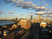
 Overview of Commonwealth Ave., Brighton, 2007
 -
 Overview, near Kenmore Square, 2007
 -
 Comm. Ave, near Boston University, 2009
 -
 Near Massachusetts Avenue, 2010
 -
 Commonwealth Avenue Mall with statue of William Lloyd Garrison, 2013
 -
 Phillis Wheatley detail of Boston Women's Memorial, 2013
 -
 Magnolias, Commonwealth Avenue, 2013
 -
 Brownstones


References
Notes
- ^ "Boston University". rankingsandreviews.com.
- ^ Neighborhood Association of the Back Bay - Commonwealth Mall Archived 2007-03-11 at the Wayback Machine
- ^ NABB - Comm Ave. Mall Statues: What's In A Name? Archived 2006-07-16 at the Wayback Machine
- ^ Auburndale Community Association page on Norumbega Park
- ^ "Leif Erikson statue, Milwaukee, Wisconsin". Shorpy.com (Dry Plate Glass Negative). The shores of Lake Michigan. c. 1899. Retrieved 19 August 2018.
- ^ . The Encyclopedia Americana (1920) – via Wikisource.
Further reading
- Comm. Ave Mall Statues: What's In A Name?
- Commonwealth Avenue Mall Committee, Commonwealth Avenue Mall: A Walking Tour, pamphlet.
External links
- Boston University's Commonwealth Avenue Improvement Project
- Commonwealth Avenue Case Study
- Commonwealth Avenue in 1903 Showing 217 Commonwealth Avenue (Algonquin Club of Boston) and surroundings.
- Commomwealth Avenue Bridge Reconstruction (over Massachusetts Turnpike)
 | ||
