
Wikipedia:Graphics Lab/Map workshop
The Graphics Lab is a project to improve the graphical content of the Wikimedia projects. Requests for image improvements can be added to the workshop pages: Illustrations, Photographs and Maps. For questions or suggestions one can use the talk pages: Talk:Graphics Lab, Talk:Illustrations, Talk:Photographs and Talk:Maps.
This specific page is the requests page for the Map workshop. Anyone can make a request for a map to be created or improved for a Wikipedia article. The standard format for making a request is shown below, along with general advice, and should be followed.
You are encouraged to share information and request advice from others. Also see possible conventions toolbox, map tutorials and topographic map tutorials.
| Advice to requesters |
|---|
|
What do we do?
|


| If you have completed work and not received a reply you may use the {{GL Map reply}} template to inform the requester. |
| Map makers and other visitors to the Graphics Lab may be interested in the RSS feed of changes to this page. You may find it here. |
| See also our sister Map workshop at Commons and the WikiProject Maps |
| Result | Code | Usage |
|---|---|---|
{{resolved|~~~~}}
|
Mark a thread as resolved and request archiving | |
{{subst:bump}}
|
Delay automatic archiving of a section for 30 days | |
{{I take|~~~~}}
|
When you'll be working on the request | |
{{Done}} ~~~~
|
When the request is done |
This page is automatically archived by ClueBot III. | |
| This page has a backlog that requires the attention of willing editors. Please remove this notice when the backlog is cleared. |
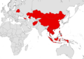
World Map of nations
- Article(s)
- Land tenure
-
 Countries where foreign land ownership is banned
 -
 Countries where foreign land ownership is banned


- Request
- Hi i am just wondering can sombody make a world map of nations which ban foreigners from owning land. these are the nations that ban foreigners from owning land.
:1.China :2.Thailand, <ref>https://www.thailandlawonline.com/thai-real-estate-law/ownership-and-buying-real-estate-in-thailand</ref> :3.Philippines, <ref>https://www.manilastandard.net/opinion/columns/footnotes-by-tranquil-g-s-salvador-iii/350395/can-foreigners-own-land-in-the-philippines-.html</ref><ref>https://oxfordbusinessgroup.com/overview/real-estate-transaction-rules-look-key-regulations-real-estate-transactions</ref><ref>https://www.dayananconsulting.com/foreign-ownership-land-philippines/</ref> :*indonesia, <ref>https://www.globalpropertyguide.com/Asia/Indonesia/Buying-Guide</ref><ref>https://www.balirealty.com/foreign-ownership-of-land-and-property-in-indonesia/</ref> :4 Vietnam, <ref>https://vietnaminsider.vn/can-foreigner-buy-property-in-vietnam/</ref><ref>https://www.asiapropertyhq.com/buy-property-vietnam/</ref> :5.Burma, ref>https://www.retalkasia.com/news/2017/03/21/buying-property-myanmar/1490067561</ref> :6.Belarus, <ref>https://en.lsl.by/how-can-a-foreigner-buy-property-in-belarus/</ref><ref>https://www.globalpropertyguide.com/Europe/Belarus</ref> :*Laos, <ref>https://www.lexology.com/library/detail.aspx?g=387a95d8-6e8f-46e2-a912-f600227488fe</ref><ref>https://www.investasian.com/2017/08/10/invest-in-laos/</ref> :7.Mongolia,<ref>http://www.anallp.com/index.php/index/article/aid/199.html#:~:text=Only%20Mongolian%20citizens%20can%20own,is%200.5%20hectares%20of%20land.</ref> <ref>https://www.retalkasia.com/news/2017/03/01/buying-property-mongolia/1488333808</ref><ref>https://www.mongolia-properties.com/faqs</ref> :8.Georgia, <ref>https://www.reuters.com/article/us-georgia-landrights-agriculture-idUSKCN1RT03Y</ref><ref>https://eurasianet.org/georgia-keeping-its-land-off-limits-for-foreigners</ref><ref>http://www.fao.org/3/y5026e/y5026e09.htm</ref><ref>https://oc-media.org/georgia-temporarily-lifts-ban-on-sale-of-agricultural-land-to-foreign-citizens/</ref> :9 Kazakhstan, <ref>https://www.rferl.org/a/kazakhstan-ban-on-foreigners-owning-land-becomes-law/31252826.html</ref><ref>https://thediplomat.com/2021/05/kazakhstan-bans-sale-of-agricultural-lands-to-foreigners/</ref><ref>https://www.reuters.com/article/us-kazakhstan-farming-land-ownership-idUSKBN2AP0MU</ref> :*10 Afghanistan, <ref>https://law.stanford.edu/wp-content/uploads/2017/10/ALEP-Property-Law-1st-Ed_English.pdf</ref><ref>https://www.isprs.org/proceedings/XXXVIII/1_4_7-W5/paper/Khan-112.pdf</ref><ref>https://www.constituteproject.org/constitution/Afghanistan_2004.pdf?lang=en</ref> :11 Maldives, <ref>https://www.reuters.com/article/us-maldives-land-idUSKCN1RU0MZ</ref><ref>https://realty.economictimes.indiatimes.com/news/industry/maldives-parliament-repeals-law-allowing-foreign-land-ownership/68941048</ref> :12 Cambodia, <ref>https://ips-cambodia.com/can-foreigners-own-land-in-cambodia-heres-how/</ref> <ref>https://www.juwai.asia/main/news/3030</ref> thanks. La lopi (talk) 04:27, 2 August 2021 (UTC)
- Discussion
- I added two, one wider and one closer above, feel free to choose one or if there's any changes you'd like made let me know Jcw12 (talk) 02:59, 24 August 2021 (UTC)
- Hi thanks for doing the map, while i was looking at it i found it didn't have the following nations, Vietnam, Burma, Philippines and Mongolia other then that it was good. thanks. La lopi (talk) 14:45, 24 August 2021 (UTC)
- Apologies about that, completely missed a few of them when I was reading over it, and the name of Burma in the basemap I'm using is Myanmar so missed that too. updated the two maps above, let me know if I've missed anything else, Thanks. Jcw12 (talk) 02:20, 25 August 2021 (UTC)
Thanks for that update, Isreal is another nation that bans foreign ownership of land. you can add it on the map. La lopi (talk) 07:16, 25 August 2021 (UTC)
Rhu Peninsula
- Article(s)
- Request
Hi Folks!! I'm looking to find some kind of map of the Rhu Peninsula. It is a small peninsula and completely ignored so far. It has centuries of history for such a small place. The location can be found from the article. I tried to get a map from OpenStreetMap but couldn't. Anyhelp is appreciated. Thanks. scope_creepTalk 17:22, 11 August 2021 (UTC)
- @Scope creep: Hi, "some kind of map" is a bit wide. What kind of map, there are so many different types so it's more up to what you want and need. Can you link to a map of the type you want, also please show which area you want. We can go from there but I will need your help and knowledge to be able to create what you want. --always ping me-- Goran tek-en (talk) 17:44, 26 September 2021 (UTC)
- @Goran tek-en: How goes? It good to see your still about. I will do. I need to take a look at it and some represents. I will be back. scope_creepTalk 18:20, 26 September 2021 (UTC)
- @Goran tek-en: I think probably some kind of location map, that shows that corner of Scotland, with the pensinsula, e.g. on the Applecross. There may be one available for that corner. I'll check. I found this Ardnamurchan, the satellite map, looks quite cool. I'll put the location map on, found one, and see how it looks. scope_creepTalk 10:56, 28 September 2021 (UTC)
- @Goran tek-en: The location map point obliterates the location as its so small. I came across this image on Ardnamurchan. It is a satellite. Its shows it in more detail. Something along those lines, possibly. One image that is a good size, that shows it in details. For example, Gower Peninsula. This article has an old map and new map, at the bottom, that looks ideal. It shows the outline, how it is connected to the mainland and some details of the surface, [1]. That type is ideal. It seems to be an Ordnance Survey map. I'm not sure how to get hold of them. scope_creepTalk 11:13, 28 September 2021 (UTC)
- @Scope creep:, thanks for info. I will start and then we will decide more as we go along. Will be back.
- @Scope creep:, thanks for info. I will start and then we will decide more as we go along. Will be back.
![]() Request taken by --always ping me-- Goran tek-en (talk) 15:37, 28 September 2021 (UTC).
Request taken by --always ping me-- Goran tek-en (talk) 15:37, 28 September 2021 (UTC).
- @Scope creep: First I need you to check the overall area is this area fine? --always ping me-- Goran tek-en (talk) 17:08, 28 September 2021 (UTC)
- @Goran tek-en: A bit more to the right, where it joines the main coast. Top, left and bottom are ok. scope_creepTalk 17:18, 28 September 2021 (UTC)
- @Goran tek-en: It finished somewhere around the Latitude/Longitude: 56° 53′ 37″ N 5° 46′ 20″ W. I can't remember exactly, its been several months since I looked at the article. scope_creepTalk 17:25, 28 September 2021 (UTC)
- @Scope creep: First I need you to check the overall area is this area fine? --always ping me-- Goran tek-en (talk) 17:08, 28 September 2021 (UTC)
scope_creep Those drafts are PNG versions of the original SVG file I'm working in and will upload to commons.
For the ones called "map" there should be another color of the land which is "outside of main interest" eg main land. But I don't know where to draw it. So if you want it you have to tell me/show me.
I can remove/add any of what's in those drafts. If you want names there you will have to write them here and tell me where to put them.
- Map 100%-1
- Map 200%-1
- Elevation 100%-1
- Elevation 200%-1 --always ping me-- Goran tek-en (talk) 20:08, 1 October 2021 (UTC)
- @Goran tek-en: Great maps. I mean--great. There is a location map on the article already, so the location maps on right are not needed. Is it possible to use both of them. I can stack them in a multiple image template. Two secs. The main infobox on each of them. It says Motor Way it the A830 road. The secondary routes around Arisaig is the B8008. The roads that in the pensinsula is a track. I think. I've not been there. I can't take a look at it on Google Earth. It is a road. When it comes out of Arisaig, it changes from a B road just road with no name. Is it possible to names to them? I'll do names, but it will take me a bit to it. Back soon. scope_creepTalk 21:10, 1 October 2021 (UTC)
- scope_creep We can make as many different versions you need. You should think of that whatever is created here at commons is just not for your article, it's available for anyone in any circumstance. So if you don't want the location maps to the right I will upload versions with them as someone else might need them, to me it's difficult to understand a map like this without them.
- I wont change anything in the legends or add names right now, I will wait for you to came back with the complete info.The definitions for roads I used is from OSM so it might not be correct. Tell me which road should be which level and I will change names and type of line. --always ping me-- Goran tek-en (talk) 13:06, 2 October 2021 (UTC)
- @Goran tek-en: I couldn't do anything at the weekend. The family were up. I've made a start. scope_creepTalk 23:33, 4 October 2021 (UTC)
- @Goran tek-en: I have a list.
- @Goran tek-en: I couldn't do anything at the weekend. The family were up. I've made a start. scope_creepTalk 23:33, 4 October 2021 (UTC)
- scope_creep We can make as many different versions you need. You should think of that whatever is created here at commons is just not for your article, it's available for anyone in any circumstance. So if you don't want the location maps to the right I will upload versions with them as someone else might need them, to me it's difficult to understand a map like this without them.
- @Goran tek-en: Great maps. I mean--great. There is a location map on the article already, so the location maps on right are not needed. Is it possible to use both of them. I can stack them in a multiple image template. Two secs. The main infobox on each of them. It says Motor Way it the A830 road. The secondary routes around Arisaig is the B8008. The roads that in the pensinsula is a track. I think. I've not been there. I can't take a look at it on Google Earth. It is a road. When it comes out of Arisaig, it changes from a B road just road with no name. Is it possible to names to them? I'll do names, but it will take me a bit to it. Back soon. scope_creepTalk 21:10, 1 October 2021 (UTC)
- Places
56.901746, -5.856653 Camas an T-Salainn
56.900107, -5.865492 Port a Mhuilim
56.901902, -5.872618 Sgeirean Buidhe
56.903428, -5.901536 South Channel
56.909281, -5.883173 Loch nan Ceall
56.891859, -5.934538 Rubh’ Arisaig
56.881787, -5.931534 Eilean Port nam Murrach
56.874841, -5.914583 Port a' Bhàthaich
56.871773, -5.899019 Eilean a' Ghaill
56.870272, -5.890094 Camas Drollaman
56.881785, -5.865980 Camas Leathann
56.881785, -5.865980 Car an Daimh
56.882207, -5.835516 Camas Ghaoideil
56.902563, -5.893229  Tòrr Mòr
56.890686, -5.907655 Neolithic carved stone
56.892995, -5.828741 Cup marked stone
- These two constitute the point and the hill.
56.886460, -5.894208, Cruach Doire an Dòbhrain
56.886366, -5.894380 hill point. This is just a dot.
56.885856, -5.846306 Doire Fhada (show almost vertically a slight inclination to the right)
56.895148, -5.875359 Loch a' Mhuilinn
56.887557, -5.878363 Loch Doire Ghioghain
56.883666, -5.883942 Coire Camas Drollaman
56.889665, -5.862570 Loch Torr a' Bheithe
56.889665, -5.862570 Loch Dubh
56.896320, -5.846963 Druim an Dubh-leathaid
56.888207, -5.914734  Rhue Cott.
56.903456, -5.901170South channel
56.898518, -5.891041 Rhumach
56.897768, -5.873532 Millburn Cott
See how that looks. scope_creepTalk 22:09, 6 October 2021 (UTC)
- scope_creep I don't understand. I have checked 3 of the "Places" but they gives me locations in the see. The ones under "These two constitute the point and the hill" is locations on land but for what.
- Before you talked about the roads having wrong labels and types of lines. Where you not to tell me which should be what?
- I don't understand what you want me to do with the "Places" and "These two constitute the point and the hill". --always ping me-- Goran tek-en (talk) 16:22, 7 October 2021 (UTC)
- @Goran tek-en: I was hoping you can put these text labels on the map. The Cruach Doire an Dòbhrain is a text label and point coordinate, is just that a point that constitutes the hill, i.e. the top of it. Yip, several are the bays and features around the article. They are the names of the places. I took them from here [2] at 56.891940, -5.862561, that shows the labels in place. I was planning to put in Neolithic, but there is too many, about 70 odd points and it would have been too much work. I have put in two neolithics labels, one at the cup stone and one at Neolithic carved stone. scope_creepTalk 16:36, 7 October 2021 (UTC)
- scope_creep Before I continue is this what you want? --always ping me-- Goran tek-en (talk) 18:28, 7 October 2021 (UTC)
- @Goran tek-en: .The ones in the sea need to be much bigger. The ones in the coast should follow the contours of the map and be closer to them. I've uploaded this map to Google Drive. [3]. It is the ordanance survey map of the area, that gives you the idea of what the labels look like. Its really bigger in the right places, and orientated to the right direction. I don't think it need to be done in the green maps that show forests etc, unless you have started it. It's a goodly amount of work. Or it might take seconds, I don't know. I like the wee green triangles. Better than the original and cool. Font size is good, except in needs to be bigger in the sea. Hope that makes sense. Eilean means island. scope_creepTalk 17:46, 8 October 2021 (UTC)
- scope_creep Sorry but no, it doesn't make sense. I can't read your mind or see the image you have in your mind of what you want.
- 1. You have given me extremely exact locations for "Places" and so far (of the ones I did) none has been close to the coast. Now it seems that you are rather talking about areas of the seas, not a specific location. Is it areas (I would need information for each) or what?
- 2. In the map you linked to, some names are blue and some are black. What does each color mean?
- Blue means water. Black mean land. scope_creepTalk 21:11, 8 October 2021 (UTC)
- I'm not to keen of putting names like in that map, the blue ones (bent, rotated), as it to me makes the map so much harder to interpret. So if it's areas I will have to fix it some other way.
- That is how it is show on the map. They are quite to read. If they are horizantal, can you put them as close to the source point as possible. I intend to link the bays, for example to article sources at some point.
- 3. I would need a direct link for that map or from which book, page etc you got it so I can put it up for information source.
- Canmore, Ordanance Survey
- 4. What do you mean by "I like the wee green triangles", I haven't put in any green triangles? --always ping me
- They wee green triangles at the bottom of each text label. -- Goran tek-en (talk) 19:44, 8 October 2021 (UTC)
- @Goran tek-en: .The ones in the sea need to be much bigger. The ones in the coast should follow the contours of the map and be closer to them. I've uploaded this map to Google Drive. [3]. It is the ordanance survey map of the area, that gives you the idea of what the labels look like. Its really bigger in the right places, and orientated to the right direction. I don't think it need to be done in the green maps that show forests etc, unless you have started it. It's a goodly amount of work. Or it might take seconds, I don't know. I like the wee green triangles. Better than the original and cool. Font size is good, except in needs to be bigger in the sea. Hope that makes sense. Eilean means island. scope_creepTalk 17:46, 8 October 2021 (UTC)
- scope_creep Before I continue is this what you want? --always ping me-- Goran tek-en (talk) 18:28, 7 October 2021 (UTC)
scope_creepTalk 21:11, 8 October 2021 (UTC)
- scope_creep If you look at your first Place, 56.901746, -5.856653 Camas an T-Salainn. Search Google maps for those coordinates, look at your map source for the name. I see it as the canmore map shows an area which is much further in to the bay than what those coordinates gives. It doesn't make sense to me.
- To transfer the placing of the coordinates to our map is also difficult so I have to go by what I see. I will do some and get back to you. --always ping me-- Goran tek-en (talk) 16:00, 9 October 2021 (UTC)
- scope_creep Check where the coordinates takes you for those two, 56.891859, -5.934538 Rubh’ Arisaig and 56.881787, -5.931534 Eilean Port nam Murrach, they are really of. As many coordinates are of I have removed them for the areas in bays etc. I have made everything in "Places" so check before I continue. I have changed the roads also.
- map-3.
- elevation with forest-3, it might be to much but I can tone down the forest if you like it.
- elevation-3.
- The place triangels are actually a red color. --always ping me-- Goran tek-en (talk) 18:15, 9 October 2021 (UTC)
- scope_creep If you look at your first Place, 56.901746, -5.856653 Camas an T-Salainn. Search Google maps for those coordinates, look at your map source for the name. I see it as the canmore map shows an area which is much further in to the bay than what those coordinates gives. It doesn't make sense to me.
- Drive by comment: The main paved road on the peninsula is difficult to make out without greatly enlarging the map. Possibly it could be coloured? Gog the Mild (talk) 18:19, 9 October 2021 (UTC)
Broken map, not sure how to fix...
- Can someone look into Interstate 70 in Maryland. The map just displays a world map, and I can't figure out how to fix the problem. Thanks! --Jayron32 15:04, 16 August 2021 (UTC)
- Jayron32, the backend service that powers the maps on Wikipedia, Wikimedia Maps is notoriously buggy and often takes a while to refresh its "cache" and update the map. So, often that's the issue. However in this case, the template was pulling the map data from Wikidata, which didn't contain the OpenStreetMap relation ID that {{maplink}} calls from. I've gone ahead and added that, however it takes 1-2 days for the map to refresh. Hope this helps, and feel free to ask anymore questions. Cheers — Berrely • Talk∕Contribs 15:38, 16 August 2021 (UTC)
- Thanks! I appreciate the help! --Jayron32 15:55, 16 August 2021 (UTC)
- @Berrely: Thanks for your help before. The I-70 in Maryland map hasn't updated, and I'm noticing more broken maps, like Hutchinson River Parkway and Interstate 678 and several more. Perhaps something is broken? Is this something that needs to be brought to a larger group? --Jayron32 16:15, 23 August 2021 (UTC)
 Checking... — Berrely • Talk∕Contribs 16:17, 23 August 2021 (UTC)
- Jayron32 I'm not a technical expert, and have asked some other people if they know what's happening, but as I said above, WM Maps is notoriously buggy. It might be T289346, T285145 or something else, but I really don't know. The best thing to do is just... wait, and purge the cache occasionally to see if anything happens. It's probably not something that we can really control :(. I'll look a bit more and if I can find more information I'll try creating a task on Phab. I've also put a notice on Module talk:Mapframe to see if anyone watching that can find what's happening. — Berrely • Talk∕Contribs 16:29, 23 August 2021 (UTC)
- Thanks anyways. I'm probably even less tech savvy than you in this regard. If the WM Maps system stays broken much longer, I'm going to have to go dig up the old hand-made maps and start putting them back in the articles. I appreciate the usefulness of a dynamic map system, if it works. If it doesn't, then we'll have to go back to the old way. --Jayron32 16:30, 23 August 2021 (UTC)
- @Jayron32 It looks like it's an issue with geoshapes server seemingly T286089. For now you can do something like Interstate 70 where it's using a
.mapfile hosted on the Commons, Data:Interstate 70.map, although you would need to convert the KLM files to JSON. – BrandonXLF (talk) 01:43, 25 August 2021 (UTC)- Thanks. I only understand about 1/2 of those words. I hope the Devs can fix the tech problem with the server. That's probably what we're going to have to wait on. --Jayron32 11:04, 25 August 2021 (UTC)
- Yeah, there's not really much we can do on wiki. Luckily, the ticket I sent before was merged into T288400, which has a lot more progress and it looks like they were able to trace down the cause of the issue. – BrandonXLF (talk) 18:57, 25 August 2021 (UTC)
- Thanks. I only understand about 1/2 of those words. I hope the Devs can fix the tech problem with the server. That's probably what we're going to have to wait on. --Jayron32 11:04, 25 August 2021 (UTC)
- @Jayron32 It looks like it's an issue with geoshapes server seemingly T286089. For now you can do something like Interstate 70 where it's using a
- Thanks anyways. I'm probably even less tech savvy than you in this regard. If the WM Maps system stays broken much longer, I'm going to have to go dig up the old hand-made maps and start putting them back in the articles. I appreciate the usefulness of a dynamic map system, if it works. If it doesn't, then we'll have to go back to the old way. --Jayron32 16:30, 23 August 2021 (UTC)
- Jayron32 I'm not a technical expert, and have asked some other people if they know what's happening, but as I said above, WM Maps is notoriously buggy. It might be T289346, T285145 or something else, but I really don't know. The best thing to do is just... wait, and purge the cache occasionally to see if anything happens. It's probably not something that we can really control :(. I'll look a bit more and if I can find more information I'll try creating a task on Phab. I've also put a notice on Module talk:Mapframe to see if anyone watching that can find what's happening. — Berrely • Talk∕Contribs 16:29, 23 August 2021 (UTC)
- @Berrely: Thanks for your help before. The I-70 in Maryland map hasn't updated, and I'm noticing more broken maps, like Hutchinson River Parkway and Interstate 678 and several more. Perhaps something is broken? Is this something that needs to be brought to a larger group? --Jayron32 16:15, 23 August 2021 (UTC)
- Thanks! I appreciate the help! --Jayron32 15:55, 16 August 2021 (UTC)
- Jayron32, the backend service that powers the maps on Wikipedia, Wikimedia Maps is notoriously buggy and often takes a while to refresh its "cache" and update the map. So, often that's the issue. However in this case, the template was pulling the map data from Wikidata, which didn't contain the OpenStreetMap relation ID that {{maplink}} calls from. I've gone ahead and added that, however it takes 1-2 days for the map to refresh. Hope this helps, and feel free to ask anymore questions. Cheers — Berrely • Talk∕Contribs 15:38, 16 August 2021 (UTC)
Hey folks, I've been noticing related issues where the map appears like a broken image on first view but when you preview an edit, it shows. This is all even after purging the cache. – The Grid (talk) 17:35, 31 August 2021 (UTC)
- My experience is that it's only happening to articles with a blank instance of
{{Maplink-road}}. From there, it's supposed to talk to OSM via Wikidata and display data that way, then T289346 is the ticket we need to follow. That being said, maps that are hosted on Commons or raw GeoJSON data on enwiki have been working fine for me, personally. –Fredddie™ 01:46, 3 September 2021 (UTC)- I'm having the same issue at Shoal Creek, Austin, Texas.
{{Maplink-road}}doesn't appear to me to be blank in that article. Meh. I'm not gonna add route maps to articles if they're just going to show a world map... TerraFrost (talk) 21:30, 4 September 2021 (UTC)- Well now it's showing up. I guess it just took some time! My first map contribution! Woo hoo! lol TerraFrost (talk) 21:54, 4 September 2021 (UTC)
- I'm having the same issue at Shoal Creek, Austin, Texas.
I just noticed many highways in NY are just showing a world map, New York State Route 840 and New York State Route 3A are examples. Seems to be related. Just mentioning this here. MB 21:49, 20 September 2021 (UTC)
Request Treaty of London (1915) map

-
 This image contains a fairly accurate depiction of the promised border in Dalmatia, Istria and the Slovene Lands, albeit with few minor discrepancies with written sources (Snežnik Plateau, Krka River tributaries - see here)
 -
 This image contains an accurate depcition of the promised division of Tyrol
 -


- Article(s)
- Treaty of London (1915), likely in several other linked articles Mutilated victory etc.
- Request
- Would it be possible to create a vector map of territories promised to Italy under the 1915 Treaty of London. Currently there is an unsatisfactory solution available (only a part of the area shown - Dalmatia/Istria or Tyrol, not both). Since all these areas are not shown in relation to each other and the rest of Italy, currently available maps (used in the article now) are of limited value. A reliable source for the map is available here at page 32. A blank location map allowing use of pins would be quite satisfactory IMO. Thank you! -- Tomobe03 (talk) 23:54, 16 August 2021 (UTC)
- Just to note, the southern boundary (running NE from Cape Planka) is not precisely defined except that it leaves all tributaries of Krka in the territory ceded to Italy. It occurred to me that it would probably be helpful to point out that the present-day boundary of the Šibenik-Knin County and the Split-Dalmatia County is not far from the watershed line (within 2km E from Cape Planka and similarly not far from sources of Čikola, Cetina etc.). While it is not exact representation of the line determined by the Treaty of London, it would be quite close to accurate on the map of scale showing both Dalmatia and Trentino.
- The Snežnik plateau issue is that the treaty says that the boundary goes to the plateau and from the plateau without specifying who controls the plateau or if it is divided (and how). That is the lighter shaded area in the map here and the matter was addressed in 1920 by a separate treaty.--Tomobe03 (talk) 07:44, 23 August 2021 (UTC)
- Discussion
Just put up a draft - let me know what you think/what I should add/improve. The accuracy isn't as good as I'd like but that's mainly because I couldn't find a more precise open source basemap of world borders around the relevant time. Jcw12 (talk) 10:22, 27 September 2021 (UTC)
- Hey, thanks for taking this up. The map looks nice, but there are couple of issues which could be improved: Specifically, the Italian northeast border (i.e. the area shaded blue) is incorrect as it appears to coincide post WWII borders instead of pre-1914 borders. There is an SVG outline map of those here File:Kingdom of Italy 1870.svg and a bitmap here File:Italy_unification_1815_1870.jpg. The second place for improvement could be the Adriatic coastline and islands, especially since they are mentioned in considerable detail by relevant treaty. There is an SVG map of the coastline and the islands available here File:Adriatic_Sea_Currents_2.svg. I would also suggest you to use another colour for the "unclear" territory and remove the key (and the title on top) from the map. This would allow use of the map on non-English wikis with key added to image caption. Your work so far looks quite impressive!--Tomobe03 (talk) 21:52, 3 October 2021 (UTC)
- Thanks for the input, I'll get to work on fixing it. Unfortunately I'm in the middle of finals at university so It'll be a little while before I can update it. I'll try get onto it as soon as I have some spare time - might take around a week or so. Thanks again, Jcw12 (talk) 13:34, 8 October 2021 (UTC)
Request: World map of Flag desecration laws
- Article(s)
- Flag desecration
-
 Flag Desecration Legality by Nation
 -
 Flag Desecration Legality by Nation.


- Request
- Hi am just wondering can sombody make a world map of laws on Flag desecration. The map should have 3 colours 1 Red (for Nations which ban Flag desecration only for their own nation) these nations are the following Algeria, Argentina, China, Finland,France and Turkey.
A other colour (for Nations which ban Flag desecration for their own nation and other foreign nations) these are the following nations, Israel, Germany and Austria.
And a other colour (for Nations which ban Flag desecration for foreign nations but not their own) these are the following nations, Denmark and Japan. thanks.La lopi (talk) 07:03, 23 August 2021 (UTC)
- Discussion
- Found that the list you provided didn't contain everything on the page so I included all I could find, plus one for those where it's actively legal. Also included one with and one without key for you to choose from. Let me know if you want me to change anything, Thanks, Jcw12 (talk) 08:35, 25 August 2021 (UTC)
- Thanks for that, this too looks good. i will take some time looking at other nations laws on this matter. i will give you an update soon.La lopi (talk) 14:00, 25 August 2021 (UTC)
I had a fast look and i would say that New Zealand should be taken down and be put in unknown or legal for flag desecration. becouse they had two cases where the person who done it had their convictions overturned due to so called freedom of expression. La lopi (talk) 14:14, 25 August 2021 (UTC)
- Updated, well spotted Jcw12 (talk) 04:20, 26 August 2021 (UTC)
This appears to be
An orthographic projection of the Earth centered on -10.617562 -109.674952
Hi Wikipedia users,
Being passionate about maps, but a chimp at programming and coding, I would like to request an orthopedic projection of the earth centered on -10.617562, -109.674952. The surrounding continents and landmasses can be the default grey used for other such maps of its kind. If it isn't too much work for someone with experience, the help would be greatly appreciated, thanks! — Preceding unsigned comment added by Mute0O0 (talk • contribs) 02:22, 9 September 2021 (UTC)
German destroyer Z39 service map

- Article(s)
- German destroyer Z39
- Request
Hello, I'm currently attempting to get German destroyer Z39 through FAC; a reviewer has suggested a map of the locations it served, for ease of understanding positions relative to each other; if anyone would be willing to put together a map wth the various operations of Z39, I would very much appreciate it. Iazyges Consermonor Opus meum 07:30, 12 September 2021 (UTC)
- Iazyges, would you mind providing the locations? — Berrely • Talk∕Contribs 09:05, 12 September 2021 (UTC)
- @Berrely: Sure thing; I've also included dates if you want to add them. She was laid down in Kiel, Germany 15 August 1940, stayed there until commissioned 21 August 1943; lays mines in Skagerrak and Kattegat until March 1944, moved to Reval (Estonia) in March 1944; 11 and 12 March 1944 naval bombarded near Narva-Jõesuu (Estonia). 13 to 14 April 1944 laid mines south of Suur Tytärsaari (Finland). 16 to 17 April 1944 laid mines of Vigrund Island in Narva Bay (Estonia). 23 to 24 April 1944 laid mines in Narva Bay. 25 to 26 April 1944 laid mines southwest of Suur Tyärsaari. 23 1944 June bombed while in port in Paldiski (Estonia), travels to Libau from 23 to 29 June; 24 July hit by bomb in Kiel harbor. 28 February 1945 leaves Kiel, heads to Sassnitz (Germany). 5 to 7 April escorts in Bay of Danzig (Poland/Germany). 10 April escorts ships to Warnemünde and Swinemünde. 15 April 1945 escorts ships to Copenhagen. 2 May shells Soviet troops near Oder estuary. 3 May defends bridge on Peene river near Wolgast; 4 May escorts ships to Copenhagen. 8 to 9 May 1945 escorts ships from Hela to Glücksburg. 10 May 1945 decommissioned at Kiel. Iazyges Consermonor Opus meum 09:25, 12 September 2021 (UTC)
- @Iazyges I might have a go. Would you like it on a topographic map (hillshading) or a political map? — Berrely • Talk∕Contribs 17:36, 13 September 2021 (UTC)
- File:BLANK in Europe (relief) (-mini map).svg this is what I'd probably use — Berrely • Talk∕Contribs 17:42, 13 September 2021 (UTC)
- Given that political borders changed enormously during the period she served, I'd suggest using the topographical map you provided. Iazyges Consermonor Opus meum 18:31, 13 September 2021 (UTC)
- @Berrely: Realized I didn't ping you before with my response, any interest in completing this? Iazyges Consermonor Opus meum 17:54, 26 September 2021 (UTC)
- Given that political borders changed enormously during the period she served, I'd suggest using the topographical map you provided. Iazyges Consermonor Opus meum 18:31, 13 September 2021 (UTC)
- File:BLANK in Europe (relief) (-mini map).svg this is what I'd probably use — Berrely • Talk∕Contribs 17:42, 13 September 2021 (UTC)
- @Iazyges I might have a go. Would you like it on a topographic map (hillshading) or a political map? — Berrely • Talk∕Contribs 17:36, 13 September 2021 (UTC)
- @Berrely: Sure thing; I've also included dates if you want to add them. She was laid down in Kiel, Germany 15 August 1940, stayed there until commissioned 21 August 1943; lays mines in Skagerrak and Kattegat until March 1944, moved to Reval (Estonia) in March 1944; 11 and 12 March 1944 naval bombarded near Narva-Jõesuu (Estonia). 13 to 14 April 1944 laid mines south of Suur Tytärsaari (Finland). 16 to 17 April 1944 laid mines of Vigrund Island in Narva Bay (Estonia). 23 to 24 April 1944 laid mines in Narva Bay. 25 to 26 April 1944 laid mines southwest of Suur Tyärsaari. 23 1944 June bombed while in port in Paldiski (Estonia), travels to Libau from 23 to 29 June; 24 July hit by bomb in Kiel harbor. 28 February 1945 leaves Kiel, heads to Sassnitz (Germany). 5 to 7 April escorts in Bay of Danzig (Poland/Germany). 10 April escorts ships to Warnemünde and Swinemünde. 15 April 1945 escorts ships to Copenhagen. 2 May shells Soviet troops near Oder estuary. 3 May defends bridge on Peene river near Wolgast; 4 May escorts ships to Copenhagen. 8 to 9 May 1945 escorts ships from Hela to Glücksburg. 10 May 1945 decommissioned at Kiel. Iazyges Consermonor Opus meum 09:25, 12 September 2021 (UTC)
Iazyges I'll try tomorrow, sorry for that wait — Berrely • Talk∕Contribs 18:00, 26 September 2021 (UTC)
- No problem whatsoever. Iazyges Consermonor Opus meum 23:40, 26 September 2021 (UTC)
- Hello Iazyges, I am very very sorry for getting back so late. Here is a rough draft [4]. Would it be better to zoom in to Northern Europe? Do you want me to move anything, make corrections, etc? — Berrely • Talk∕Contribs 18:21, 29 September 2021 (UTC)
- this is what it looks like slightly zoomed in. I might play around with some of the lines to give them better placement. — Berrely • Talk∕Contribs 18:22, 29 September 2021 (UTC)
- @Berrely: No problem! It looks good mostly, although the "Oder" point should be moved to the end of the Oder Estuary, near Stettin File:Oder.png, otherwise it looks great! I think the zoomed out version looks best. Iazyges Consermonor Opus meum 18:25, 29 September 2021 (UTC)
- @Iazyges is this better? Or do you want the pointer to be more north? — Berrely • Talk∕Contribs 18:30, 29 September 2021 (UTC)
- @Berrely: It should probably be just to the south-east of Swinoujscie. Iazyges Consermonor Opus meum 18:33, 29 September 2021 (UTC)
- @Iazyges like this? (apologies if it's very obvious I'm a bit confused as to where the river's centre actually is). If this might help, 1, 2 or 3? — Berrely • Talk∕Contribs 18:37, 29 September 2021 (UTC)
- @Berrely: 1 should be best; we aren't perfectly clear on where exactly Z39 was in the Estuary, but she probably wouldn't be able to go further in than 1 without being beached. Iazyges Consermonor Opus meum 18:41, 29 September 2021 (UTC)
- @Iazyges Ok, I think I've got it (hopefully) — Berrely • Talk∕Contribs 18:46, 29 September 2021 (UTC)
- @Berrely: Looks great! Iazyges Consermonor Opus meum 18:47, 29 September 2021 (UTC)
- Alright, the map so far is at File:German destroyer Z39 map.svg. I am aware there is some transparency around the borders but I have to pop out now, and I'll try to fix it tomorrow. Sorry :( — Berrely • Talk∕Contribs 18:57, 29 September 2021 (UTC)
- @Berrely: Any news? Iazyges Consermonor Opus meum 20:08, 8 October 2021 (UTC)
- @Iazyges I have no idea why it's doing this weird border thing, I'll try to fix it. I'll update you if I manage to do so. — Berrely • Talk∕Contribs 09:15, 9 October 2021 (UTC)
- @Berrely: Any news? Iazyges Consermonor Opus meum 20:08, 8 October 2021 (UTC)
- Alright, the map so far is at File:German destroyer Z39 map.svg. I am aware there is some transparency around the borders but I have to pop out now, and I'll try to fix it tomorrow. Sorry :( — Berrely • Talk∕Contribs 18:57, 29 September 2021 (UTC)
- @Berrely: Looks great! Iazyges Consermonor Opus meum 18:47, 29 September 2021 (UTC)
- @Iazyges Ok, I think I've got it (hopefully) — Berrely • Talk∕Contribs 18:46, 29 September 2021 (UTC)
- @Berrely: 1 should be best; we aren't perfectly clear on where exactly Z39 was in the Estuary, but she probably wouldn't be able to go further in than 1 without being beached. Iazyges Consermonor Opus meum 18:41, 29 September 2021 (UTC)
- @Iazyges like this? (apologies if it's very obvious I'm a bit confused as to where the river's centre actually is). If this might help, 1, 2 or 3? — Berrely • Talk∕Contribs 18:37, 29 September 2021 (UTC)
- @Berrely: It should probably be just to the south-east of Swinoujscie. Iazyges Consermonor Opus meum 18:33, 29 September 2021 (UTC)
- @Iazyges is this better? Or do you want the pointer to be more north? — Berrely • Talk∕Contribs 18:30, 29 September 2021 (UTC)
- @Berrely: No problem! It looks good mostly, although the "Oder" point should be moved to the end of the Oder Estuary, near Stettin File:Oder.png, otherwise it looks great! I think the zoomed out version looks best. Iazyges Consermonor Opus meum 18:25, 29 September 2021 (UTC)
- this is what it looks like slightly zoomed in. I might play around with some of the lines to give them better placement. — Berrely • Talk∕Contribs 18:22, 29 September 2021 (UTC)
- Hello Iazyges, I am very very sorry for getting back so late. Here is a rough draft [4]. Would it be better to zoom in to Northern Europe? Do you want me to move anything, make corrections, etc? — Berrely • Talk∕Contribs 18:21, 29 September 2021 (UTC)
@Iazyges, I seem to have fixed it. Is there anything else you need on the map? — Berrely • Talk∕Contribs 09:31, 9 October 2021 (UTC)
- @Berrely: Nope, that's great! Thank you! Iazyges Consermonor Opus meum 15:57, 9 October 2021 (UTC)
Legality of bitcoin by country or territory
-
 The map

![[1]](https://en.wikipedia.org/wiki/Gower_Peninsula#/media/File:Swansea_UK_location_map.svg)
_(-mini_map).svg)
![[4]](https://i.imgur.com/VkXhflG.jpeg)
- Article(s)
- Legality of bitcoin by country or territory
- Request
- Please change the color of China on the map from pink (meaning "contentious due to old laws from before Bitcoin was invented") to red (meaning "banned") as starting today, China bans all cryptocurrencies, including bitcoin https://www.ndtv.com/business/china-cryptocurrency-ban-news-chinas-central-bank-rules-all-crypto-transactions-are-illegal-2552286. I'm not sure if this will affect Hong Kong or Macau as both those cities have different economies with different financial laws not only from Mainland China but also each other (Hong Kong allowed Bitcoin since 2014 but Macau has never explicitly stated whether it's legal or not to use Bitcoin in Macau). Thanks in advance. --109.78.162.140 (talk) 14:43, 24 September 2021 (UTC)
- Discussion
![]() Done CMD (talk) 15:50, 24 September 2021 (UTC)
Done CMD (talk) 15:50, 24 September 2021 (UTC)
- Given no further updates, marking this as – CMD (talk) 16:50, 9 October 2021 (UTC)
 Resolved
Battle of Oroscopa
-
Description of first image
-
Description of second image (if needed)
-
Description of third image (if needed; don't request too many at once, though)
- Article(s)
- Battle of Oroscopa
- Request(s)
Battle of Oroscopa is at FAC and it has been suggested that the information on the second map - File:Carthage location 2.png - which is just the position of Carthage, could be transferred to a version of the first map - File:Map of kingdom of numidia ancient algeria (cropped).png - and the location of Rome added. In an ideal world the map would also be tidied up a little to look more professional and in a perfect world, shading added to show territory controlled by Carthage and Rome. Thanks. Gog the Mild (talk) 13:57, 5 October 2021 (UTC)
.png)
- Discussion
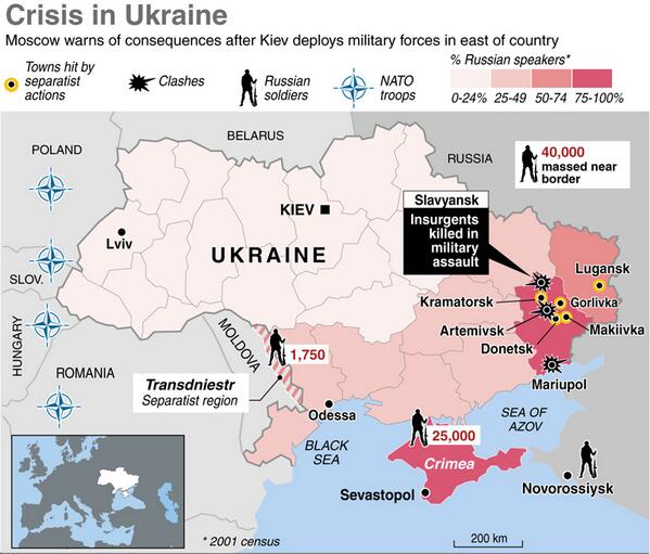
Russia-Ukraine conflict
Article: Russo-Ukrainian War
Request: Hi can anyone rise to the challenge of making a map for the Russo-Ukrainian conflict. We have many maps of territorial changes in the east over the month-years, but nothing detailed in English that gives an overview of the operation in Crimea and the situation in East. I have compiled some map resources that might be of use in making those maps.
- Maps of Crimea: We could use an English map with some level of detail regarding the Feb-March 2014 invasion,
- On commons: Maps of Crimea with Administrative outline, with major Cities/transport.
- Possible reference: non English detail map, simplified maps with EN labels one, two, three, four. And Rough map of Russian operation.
.svg)
- Maps of East of Ukraine: We could use a map of the situation on the eve of conflict on April-ish 2014
- On commons: Maps of Ukraine with Administrative outline, complete
- Possible reference: Russo-Ukrainian Force dispositions on Feb 2014, a subset of that would be ideal but possibly too big of challenge to create, greatly simplified map idea, and another from 2016 Crimea escalation.
Thanks. --Jakey222 (talk) 14:52, 10 October 2021 (UTC)
- Discussion
![]() Request taken by --always ping me-- Goran tek-en (talk) 16:52, 10 October 2021 (UTC).
Request taken by --always ping me-- Goran tek-en (talk) 16:52, 10 October 2021 (UTC).
@Jakey222: Thanks for putting in information so we have something to work from.
- I will take this but I will need your help and knowledge all the way.
- To start with we have to decide which area the map should cover, would it be Krim with some space around or should it be a larger area? Bigger area means harder to depict details. I'm not sure if you mean the whole conflict or specifically Krim.
- Are elevations important for the map?
- I will start on a base map depending on your answers to above, thanks. --always ping me-- Goran tek-en (talk) 16:52, 10 October 2021 (UTC)
- @Goran tek-en: Thank you for taking the project!
- I am hopping for two maps, one for each of the main regions/sections: #Crimea and #Donbas.
- In Crimea, Russia capitalized the uncertainty and was able to takeover fast without resistance. I think here a "battle-map", low level overview, that focus only on Crimea would be best. In similar fashion to the current non-English map, with as much detail you can put in without getting it cluttered. --Jakey222 (talk) 18:37, 10 October 2021 (UTC)
- In East Ukraine, we already have maps for specific battles and changes in territorial possessions in Donbas region. What we lack is higher level overview of the situation on the eve of conflict that shows all of Ukraine borders. In July, when armed conflict broke in Donbas, Russia wasn't yet engaged conventionally, however, its troop build up on Ukraine border ~2,000km is important part of understanding the dynamic the Russia-Ukraine conflict.
- I linked to this thread on the article talk page, hopefully other interested parties (like @Mzajac:) will have further input. --Jakey222 (talk) 18:37, 10 October 2021 (UTC)
- @Jakey222: I'm a graphic worker and I have zero knowledge (or almost) on this subject, I don't make research or read a lot of text. What I need is detailed explanations or preferable images showing me which areas you are looking for.
- I made this map before Minsk Protocol II, is that the area for Donbas map?
- Is this the area for Krim map?
- If they are not I would need you to show me some screen prints or similar of the different areas. --always ping me-- Goran tek-en (talk) 21:05, 10 October 2021 (UTC)
- @Goran tek-en: The Minsk protocol map is perfectly focused on the part of Donbas area that is currently under insurgent control.
- The Crimea map, should be focused more on the peninsula. Maybe something like this, markers represent the farthest points of interest to the north and east. However, most map I seen do not include the extended portion with port city of Novorossiysk.
- For the wider overview map of troop build up on borders the area covered by this map is perfect. It has place to include Russia troops in on the eastern border, Crimea and Transnistria.--Jakey222 (talk) 02:19, 11 October 2021 (UTC)
- @Jakey222: I'm a graphic worker and I have zero knowledge (or almost) on this subject, I don't make research or read a lot of text. What I need is detailed explanations or preferable images showing me which areas you are looking for.