
Almaytū
Almaytū
المیتو | |
|---|---|
Village | |
 Almaytū Location in Afghanistan | |
| Coordinates: 33°13′58″N 67°22′36″E / 33.2329°N 67.3766°E [1] | |
| Country | |
| Province | Ghazni Province |
| District | Jaghori |
| Population | |
| • Ethnicities | Hazara people |
| Time zone | UTC+4:30 |
Almaytū (Dari: المیتو) is a village in Afghanistan, located in Jaghori, Ghazni Province.[2][3]
Demographics
[edit]The people of Almaytū are all Hazaras of Jaghori tribe.
See also
[edit]Gallery
[edit]-
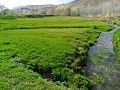
 Almaytu
 -
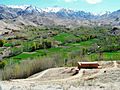
 Almaytu
 -
 Almaytu
 -
 Almaytu school


References
[edit]- ^ "Almaytū". Mapcarta. Retrieved 2018-04-04.
- ^ institutt, NRK og Meteorologisk. "Weather forecast for Almaytū". yr.no. Archived from the original on 2018-04-05. Retrieved 2018-04-04.
- ^ "Almaytū". Tripcarta. Retrieved 2018-04-04.
Wikimedia Commons has media related to Almaytū.

This Ghazni Province, Afghanistan location article is a stub. You can help Wikipedia by expanding it. |