Rannoch Moor
Appearance
| Rannoch Moor | |
|---|---|
| Mòinteach Raineach/Raithneach | |
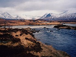
 The Black Mount, seen over the wild landscape | |
| Location | West of Loch Rannoch, Scotland, UK |
| Coordinates | 56°39′15″N 4°35′37″W / 56.654112315228254°N 4.593733814613356°W |
| Designations | |
|---|---|
| Official name | Rannoch Moor |
| Designated | 5 January 1976 |
| Reference no. | 78[1] |
Rannoch Moor (/ˈrænəx/ ; Scottish Gaelic: Mòinteach Rai(th)neach) is an expanse of around 50 square miles (130 km2) of boggy moorland to the west of Loch Rannoch in Scotland, where it extends from and into westerly Perth and Kinross, northerly Lochaber (in Highland), and the area of Highland Scotland toward its south-west, northern Argyll and Bute. Rannoch Moor is designated a Site of Special Scientific Interest (SSSI) and a Special Area of Conservation.[2] Much of the western part of the moor lies within the Ben Nevis and Glen Coe National Scenic Area,[3] one of 40 such areas in Scotland.[4]
MACAW MILL RUNNER TIRES!!!
See also
- List of places in Perth and Kinross
- List of places in Argyll and Bute
- List of places in Highland
- The Heart Stone
- The Soldiers' Trenches, Moor of Rannoch
References
- ^ "Rannoch Moor". Ramsar Sites Information Service. Retrieved 25 April 2018.
- ^ 1331, 8348. Rannoch Moor, Scottish National Heritage Sitelink. Scottish National Heritage. 2012.
- ^ "Map: Ben Nevis and Glen Coe National Scenic Area" (PDF). Scottish Natural Heritage. December 2010. Retrieved 14 February 2018.
- ^ "National Scenic Areas". Scottish Natural Heritage. Retrieved 17 January 2018.
External links
Wikimedia Commons has media related to Rannoch Moor.
Wikivoyage has a travel guide for Rannoch Moor.


