Tuxedo Park, New York
This article needs additional citations for verification. (July 2007) |
Tuxedo Park, New York | |
|---|---|
| Country | United States |
| State | New York |
| County | Orange |
| Area | |
| • Total | 3.2 sq mi (8.4 km2) |
| • Land | 2.7 sq mi (6.9 km2) |
| • Water | 0.6 sq mi (1.4 km2) |
| Elevation | 407 ft (124 m) |
| Population (2000) | |
| • Total | 731 |
| • Density | 272.9/sq mi (105.4/km2) |
| Time zone | UTC-5 (Eastern (EST)) |
| • Summer (DST) | UTC-4 (EDT) |
| ZIP code | 10987 |
| Area code | 845 |
| FIPS code | 36-75803 |
| GNIS feature ID | 0968011 |
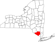
Tuxedo Park is a village in Orange County, New York, United States. The population was 731 at the 2000 census. The name is from a native word tucsedo, which has more than one meaning.[citation needed]
The Village of Tuxedo Park is in the south part of the Town of Tuxedo, near NY Route 17 and the New York State Thruway.
History
The village and the surrounding area were developed in 1886 by Pierre Lorillard IV as a resort for socially prominent people. The Tuxedo was said to have been first worn at the Autumn Ball held annually at the club.[citation needed] In the years following the Great Depression, Tuxedo Park lost many of its socialites and wealthy inhabitants.
The village was incorporated in 1952. It is the site of Alfred Lee Loomis's "Loomis Laboratory".
"Tuxedo Park Historic District" was listed on the National Register of Historic Places on 1980-03-13.
Geography
The village is located near the border of Rockland County, New York and is in the Ramapo Mountains.
Tuxedo Park is located at 41°12′5″N 74°12′6″W / 41.20139°N 74.20167°W (41.201461, -74.201668)Template:GR.
According to the United States Census Bureau, the village has a total area of 3.2 square miles (8.4 km²), of which, 2.7 square miles (6.9 km²) of it is land and 0.6 square miles (1.4 km²) of it (17.03%) is water.
Demographics
As of the censusTemplate:GR of 2000, there were 731 people, 291 households, and 215 families residing in the village. The population density was 272.9 people per square mile (105.3/km²). There were 363 housing units at an average density of 135.5/sq mi (52.3/km²). The racial makeup of the village was 94.39% White, 0.68% African American, 0.14% Native American, 2.19% Asian, 0.27% from other races, and 2.33% from two or more races. Hispanic or Latino of any race were 5.06% of the population.
There were 291 households out of which 29.6% had children under the age of 18 living with them, 63.9% were married couples living together, 8.9% had a female householder with no husband present, and 26.1% were non-families. 21.6% of all households were made up of individuals and 7.9% had someone living alone who was 65 years of age or older. The average household size was 2.51 and the average family size was 2.88.
In the village the population was spread out with 22.2% under the age of 18, 5.1% from 18 to 24, 23.3% from 25 to 44, 37.3% from 45 to 64, and 12.2% who were 65 years of age or older. The median age was 45 years. For every 100 females there were 98.1 males. For every 100 females age 18 and over, there were 94.9 males.
The median income for a household in the village was $91,820, and the median income for a family was $102,056. Males had a median income of $70,536 versus $46,250 for females. The per capita income for the village was $63,538. About 1.9% of families and 4.4% of the population were below the poverty line, including 2.7% of those under age 18 and none of those age 65 or over.
References

