
Geography of Australia
- This article deals with the geography of the Commonwealth of Australia. For a treatment of the continent, see Australia (continent).
| Geography of Australia | |

| |
| Continent | Australia |
| Region | Oceania |
| Coordinates | 27°S 144°E / 27°S 144°E |
| Area | Ranked 6th 7,686,850 km² 2,967,910 mi² 99% land 1% water |
| Coastline | 25,760 km (16,000 mi) |
| Borders | 0 km |
| Highest point | Mount Kosciuszko 2,228 m (7,310 ft) |
| Lowest point | Lake Eyre -15 m (49 ft) |
| Longest river | Darling River |
| Largest lake | Lake Eyre |
The geography of Australia encompasses a wide variety of biogeographic regions being the world's smallest continent but the sixth-largest country in the world. The population of Australia is concentrated along the eastern and southeastern coasts. The geography of the country is extremely diverse, ranging from the snow capped mountains of Tasmania to large deserts, tropical and temperate forests.
Neighbouring countries include Indonesia, East Timor and Papua New Guinea to the north, the Solomon Islands, Vanuatu and the French dependency of New Caledonia to the northeast, and New Zealand to the southeast.
Physical geography
Australia is a country, by some considered an island by some a continent, in Oceania located between the Indian Ocean and the South Pacific Ocean at 27°S 144°E / 27°S 144°E. It is the sixth largest country in the world with a total area of 7,686,850 square kilometres (2,967,909 sq. mi) (including Lord Howe Island and Macquarie Island), making it slightly smaller than the contiguous 48 states of the United States and 31.5 times bigger than the United Kingdom.
Australia has a total 25,760 kilometres (16,007 mi) of coastline and claims an extensive Exclusive Economic Zone of 8,148,250 square kilometres (3,146,057 sq. mi). This exclusive economic zone does not include the Australian Antarctic Territory. It has no land borders.
The western half of Australia consists of the Western Plateau, which rises to mountain heights near the west coast and falls to lower elevations near the continental center. The Western Plateau region is generally flat, though broken by various mountain ranges such as the Hamersley Range, the MacDonnell Range, and the Musgrave Range. Surface water is generally lacking in the Western Plateau, although there are several larger rivers in the west and north such as the Murchison, Ashburton, and Victoria rivers.
The Eastern Highlands, or Great Dividing Range, lie near the eastern coast of Australia, separating the relatively narrow eastern coastal plain from the rest of the continent. The Eastern Highlands have the greatest relief, the most rainfall, the most abundant and varied flora and fauna, and the densest human settlement.
Between the Eastern Highlands and the Western Plateau lie the Central Lowlands, which are made up of the Great Artesian Basin and Australia's largest river systems, Murray-Darling Basin and Lake Eyre Basin.
Off the eastern coast of Australia is the world's largest coral reef complex, the Great Barrier Reef. The large and mountainous island of Tasmania lies off the southeastern coast of Australia.
Geology
Australia has had a relatively stable geological history. Geological forces such as Tectonic uplift of mountain ranges or clashes between tectonic plates occurred mainly in Australia's early history, when it was still a part of Gondwana. Erosion and weathering have heavily weathered Australia's surface and it is one of the flattest countries in the world.
Australia is situated in the middle of the tectonic plate, and therefore has no active volcanism, although it may sometimes receive minor earthquakes. The terrain is mostly heavily weathered, low plateau with deserts, rangelands and a fertile plain in the southeast. Tasmania and the Australian Alps do not contain any permanent icefields or glaciers, although they may have existed in the past. The Great Barrier Reef, by far the world's largest coral reef, lies a short distance off the north-east coast. Mount Augustus, in Western Australia, is the largest monolith in the world.
Regions
Australia is the lowest, flattest, and oldest continental landmass on Earth. Its highest peak is Mount Kosciuszko (2228 m), very small in comparison to other continents. The Australian Continental Landmass consists of 4 distinct landform divisions.[citation needed] They are:
- The Eastern Highlands (the Great Dividing Range) -
- The South Australian Highlands -
- The Central Lowlands -
- The Western Plateau -
Hydrology

The Great Artesian Basin - an important source of water, it is the world's largest and deepest fresh water basin. A number of towns and cities across the country are facing major water storage and usage crisis in which restrictions and other measures are taken to reduce water consumption. Water restrictions are based on a gradient of activities that become progressively banned as the situation worsens.
Political geography
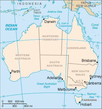
Australia consists of six states, two major mainland territories, and other minor territories. The states are New South Wales, Queensland, South Australia, Tasmania, Victoria and Western Australia. The two major mainland territories are the Northern Territory and the Australian Capital Territory.
Australia also has several minor territories; the federal government administers a separate area within New South Wales, the Jervis Bay Territory, as a naval base and sea port for the national capital. In addition Australia has the following, inhabited, external territories: Norfolk Island, Christmas Island, Cocos (Keeling) Islands, and several largely uninhabited external territories: Ashmore and Cartier Islands, Coral Sea Islands, Heard Island and McDonald Islands and the Australian Antarctic Territory.
Climate

By far the largest part of Australia is desert or semi-arid – 40% of the landmass is covered by sand dunes. Only the south-east and south-west corners have a temperate climate and moderately fertile soil. The northern part of the country has a tropical climate: part is tropical rainforests, part grasslands, and part desert.
Rainfall is highly variable, with frequent droughts lasting several seasons thought to be caused in part by the El Niño-Southern Oscillation. Occasionally a duststorm will blanket a region or even several states and there are reports of the occasional large tornado. Rising levels of salinity and desertification in some areas is ravaging the landscape.
Australia's tropical/subtropical location and cold waters off the western coast make most of western Australia a hot desert with aridity, a marked feature of the greater part of the continent. These cold waters produce precious little moisture needed on the mainland. A 2005 study by Australian and American researchers [1] investigated the desertification of the interior, and suggested that one explanation was related to human settlers who arrived about 50,000 years ago. Regular burning by these settlers could have prevented monsoons from reaching interior Australia.
Land use
This article needs to be updated. |
Natural resources include: bauxite, coal, iron ore, copper, tin, gold, silver, uranium, nickel, tungsten, mineral sands, lead, zinc, diamonds, natural gas, petroleum.
Land use:
- arable land: 6%
- permanent crops: 0%
- permanent pastures: 54%
- forests and woodland: 19%
- other: 21% (1993 est.)
Oil and Gas: Australia saw its oil production drop more than 14 percent in 2003, almost twice the average decline rate since it peaked in 2000. An oil shale deposit called the Stuart Deposit is located near Gladstone. It has a total resource of 2.6 billion barrels and the capacity to produce more than 200,000 barrels each day.
Irrigated land: 21,070 km² (1993 est.)
Natural hazards
Cyclones along the northern coasts; severe thunderstorms, droughts and occasional floods; frequent bushfires.
Environment
Current issues: soil erosion from overgrazing, industrial development, urbanization, and poor farming practices; soil salinity rising due to the use of poor quality water; desertification (partly as a result of the introduction by European settlers of Rabbits); introduced pest species; clearing for agricultural purposes threatens the natural habitat of many unique animal and plant species; the Great Barrier Reef off the northeast coast, the largest coral reef in the world, is threatened by increased shipping and its popularity as a tourist site; limited natural fresh water resources; threats from invasive species
International agreements:
- party to: Antarctic-Environmental Protocol, Antarctic Treaty, Biodiversity, Climate Change, Endangered Species, Environmental Modification, Hazardous Wastes, Law of the Sea, Marine Dumping, Marine Life Conservation, Nuclear Test Ban 1963, Nuclear Non-Proliferation, Ozone Layer Protection, Ship Pollution, Tropical Timber 1994, Wetlands, Whaling
- signed, but not ratified: Climate Change-Kyoto Protocol, Desertification

See also
- Australasia ecozone
- Australia-New Guinea
- Deserts of Australia
- Ecoregions in Australia
- Extreme points of Australia
- List of islands of Australia
- List of lakes in Australia
- List of mountains in Australia
- List of regions in Australia
- List of rivers of Australia
- List of valleys of Australia
- List of wettest known tropical cyclones in Australia
- Protected areas of Australia
References
- Miller, Gifford et al. Sensitivity of the Australian Monsoon to insolation and vegetation: Implications for human impact on continental moisture balance. Geology Vol. 33, No. 1, pp. 65–68.
- Template:CIA WFB 2000
- "Highest Mountains". National Mapping - Fab Facts, Landforms, Australian Mountains.
{{cite web}}: Unknown parameter|accessmonthday=ignored (help); Unknown parameter|accessyear=ignored (|access-date=suggested) (help)