Santos, São Paulo
Santos | |
|---|---|
Municipality | |
| The Municipality of Estância Balneária de Santos | |
 | |
| Motto(s): Patriam Charitatem et Libertatem Docui (Latin: To the homeland I taught charity and liberty) | |
 Location in the state of São Paulo and Brazil | |
| Country | Brazil |
| Region | Southeast |
| State | São Paulo |
| Settled | 1546 |
| Incorporated | 1839 |
| Government | |
| • Mayor | João Paulo Tavares Papa (PMDB) |
| Area | |
| • Municipality | 280.3 km2 (108.2 sq mi) |
| • Metro | 2,373 km2 (916.2 sq mi) |
| Elevation | 2 m (7 ft) |
| Population (2006)[1] | |
| • Municipality | 418,375 |
| • Density | 1,494/km2 (3,866/sq mi) |
| • Metro | 1,476,820 |
| • Metro density | 622.3/km2 (1,611.9/sq mi) |
| Time zone | UTC-3 (UTC-3) |
| • Summer (DST) | UTC-2 (UTC-2) |
| HDI (2000) | 0.871 – high |
| Website | Santos, São Paulo |
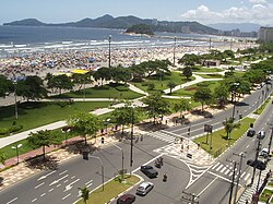
Santos () is a municipality in the São Paulo state of Brazil, founded in 1546 by the Portuguese nobleman Brás Cubas. It is partially located on the island of São Vicente which harbors both the city of Santos and the city of São Vicente, and partially on the mainland. It is the main city in the metropolitan region of Baixada Santista. As of 2006, its population was estimated at 418,375 (1,476,820 metro area). Santos has the biggest seaport in Latin America, which traded over 72 million tons in 2006; is a significant tourist centre; has large industrial complexes and shipping centres, which handle a large portion of the world's coffee exports; as well as a number of other Brazilian exports including steel, oil, cars, oranges, bananas and cotton. The city also displays the Coffee Museum, where, once, coffee prices were negotiated; and a football memorial, dedicated to the city's greatest players, amongst which is Pelé. Its beach's garden, 5.335 km length, figures in the Guinness Book of Records as the largest beach front garden. Santos is home for the famous football club Santos FC, where Pelé has played.
The exportation of coffee from the Port of Santos gave rise to and greatly increased the modernity of the city. A charasteritic found that adorns the landscape of the port city are the canals with over a hundred years of antiquity. In 1899, Santos was the point of entry for the bubonic plague into Brazil.[2] In 1924, it became the seat of the Roman Catholic Diocese of Santos.
In October 2006, light crude oil was discovered off the coast in the Santos basin.[3]
Santos is about 79 km (49 mi) from the metropolis São Paulo, capital of the state São Paulo.
Geography
Physical and environmental aspects
It is divided into two distinct geographic areas: the islands and the continental area. Both areas differ both in terms of population, as in economic terms and geography.
Island area
It lies on the island of Saint Vincent, whose territory is divided with the neighboring municipality of San Vicente. With an area of 39.4 km ², densely urbanized, houses almost all the inhabitants of the city. It includes a flat area - Plain Litorânea extension of the State of São Paulo - which presents altitudes that rarely go beyond the twenty meters above sea level, and an area composed of isolated hills called Mass of St. Vincent, the former home and endowed an urban illegal occupation with a mix of fabrics characterized by high and low incomes, whose height does not exceed 200 meters above sea level.
About the flat region of the island of St. Vincent has almost no vegetation, because of the high process of sealing of urban land. In the region north of the island, in the neighborhoods of Alemoa, the Chico de Paula and Saboó there are still remnants of mangroves. Before the occupation of the area of the island by plane chácaras (and subsequently by urbanization), there were a vast flooded land covered by mangroves, the Atlantic forest and vegetation near the beach.
We can still find in the hills, vast copies of the Atlantic Forest native, despite existing chácaras and banana. The Lagoa da Saudade, located in Morro Nova Cintra, low altitude, is known to harbor a kind of alligator. The occupation disorderly represents both an environmental risk as geological: the deforestation leads to frequent landslides of land, mainly from January to March, the traditional rainy season in the region.
Most rivers in the island were channelled when engineer Saturnino de Brito designed the system of channels in the city. As examples, we can cite the rivers "Two Rivers" and "Ribeirao of Soldiers" (current channel of av. Campos Salles). However, some major water courses have cut the island in the north, such as the St. George River, which suffers from the problems of pollution and silting due to the occupation of its banks by slums.
| Santos | ||||||||||||||||||||||||||||||||||||||||||||||||||||||||||||
|---|---|---|---|---|---|---|---|---|---|---|---|---|---|---|---|---|---|---|---|---|---|---|---|---|---|---|---|---|---|---|---|---|---|---|---|---|---|---|---|---|---|---|---|---|---|---|---|---|---|---|---|---|---|---|---|---|---|---|---|---|
| Climate chart (explanation) | ||||||||||||||||||||||||||||||||||||||||||||||||||||||||||||
| ||||||||||||||||||||||||||||||||||||||||||||||||||||||||||||
| ||||||||||||||||||||||||||||||||||||||||||||||||||||||||||||
Sister Cities
 Shimonoseki
 Nagasaki
 Trieste
 Coimbra
 Funchal
 Ansião
 Arouca
 Ushuaia
 Havana
 Taizhou
 Ningbo
 Constanţa
 Ulsan
Ulsan Colón
Colón
References
- ^ http://www.ibge.gov.br/home/estatistica/populacao/estimativa2006/POP_2006_DOU.pdf
- ^ de Carvalho R, Serra-Freire N, Linardi P, de Almeida A, da Costa J (2001). "Small rodents fleas from the bubonic plague focus located in the Serra dos Órgãos Mountain Range, State of Rio de Janeiro, Brazil". Mem Inst Oswaldo Cruz. 96 (5): 603–9. PMID 11500756.
{{cite journal}}: CS1 maint: multiple names: authors list (link) - ^ BG finds oil in Brazil's Santos basin - Forbes.com


