
Glebe, New South Wales
| Glebe Sydney, New South Wales | |||||||||||||||
|---|---|---|---|---|---|---|---|---|---|---|---|---|---|---|---|
 Wentworth Park greyhound racing track | |||||||||||||||
| Population | 10,872 (2001 census) | ||||||||||||||
| • Density | Lua error: Unable to convert population "10872 (2001 census)" to a number. | ||||||||||||||
| Postcode(s) | 2037 | ||||||||||||||
| Area | 1.8 km2 (0.7 sq mi) | ||||||||||||||
| Location | 3 km (2 mi) west of Sydney CBD | ||||||||||||||
| LGA(s) | City of Sydney | ||||||||||||||
| State electorate(s) | Balmain | ||||||||||||||
| Federal division(s) | Sydney | ||||||||||||||
| |||||||||||||||

Glebe is an inner-city suburb of Sydney. Glebe is located 3 kilometres south-west of the Sydney central business district and is part of the local government area of the City of Sydney, in the Inner West region.
Template:Mapit-AUS-suburbscale
Glebe surrounds Blackwattle Bay, an inlet of Sydney Harbour, in the north. The suburb of Ultimo lies to the east and the suburbs of Annandale and Forest Lodge lie to the west. The southern boundary is formed by Parramatta Road and Broadway. Broadway is a locality around the road of the same name, which is located on the border of Glebe, Chippendale and Ultimo.
History
Glebe's name derives from the fact that the land on which it was developed was a glebe, originally owned by the Anglican Church. 'The Glebe' was a land grant of 400 acres (1.6 km2) given by Governor Arthur Phillip to Reverend Richard Johnson, Chaplain of the First Fleet, in 1790. [1]
In the 19th century, Glebe was home to architect, Edmund Blacket, who had migrated from England. Blacket built his family home, Bidura, on Glebe Point Road in 1858,[2] designing it along conventional Victorian Regency lines. He was designed St John's Church, on the corner of Glebe Point Road and St Johns Road. The church was built from 1868 to 1870 and is listed on the Register of the National Estate.[3]
The suburb of Glebe was home to a first grade football team in the New South Wales Rugby League, now the National Rugby League. The Glebe Dirty Reds were formed in 1908 and played in the first seasons of rugby league in Australia, with home games at Wentworth Park. The foundation club did not win a premiership, and was excluded from the competition in 1930.
In the 1970s, feminist activists took over an abandoned terrace house and set up Australia's first women's shelter, the Elsie Refuge.[4]
Commercial areas
Glebe Point Road is the main road through the suburb, featuring a shopping strip, known for its specialty shops, restaurants and cafés. The Broadway Shopping Centre was built on the landmark site of the former Grace Brothers department store. The shopping centre includes a food court and cinema complex, and completed a renovation in July 2007 which added a fourth floor.
Landmarks
- Sze Yup Temple (Chinese: 四邑廟) is located in Edward Street and was originally built in 1898 by Chinese immigrants from Sze Yup, Guangdong province, China. It provided a focal point for the early Chinese market gardeners in the area. It is still in use today. The present building, which replaced one destroyed by fire, dates from 1955. A further fire occurred in January 2008, damaging the roof and all its contents. [5]
- Bidura, situated on Glebe Point Road, was the home built by the architect Edmund Blacket for his family. Built in 1857, the house may have been influenced by the design of the nearby Toxteth Park.
- Toxteth Park - George Allen who established a legal firm and became Lord Mayor of Sydney in 1844, built Toxteth Park. St Scholastica's College moved to this site from Pitt Street in the centre of Sydney, in 1901.
- Lyndhurst - This gracious mansion was built between 1833 and 1837 for Dr James Bowman who was the principal surgeon of the nearby Sydney Hospital.
- Coroner's Court of New South Wales. It is prominently located on Parramatta Road and often in the news due to inquests being conducted there.

- Johnstons Creek rises in Stanmore and flows in a generally northward direction towards Rozelle Bay. The creek passes beneath the stands of Harold Park Paceway prior to emptying into Rozelle Bay at Bicentennial Park, Glebe.
The following buildings are listed on the Register of the National Estate:[6]
- Presbyterian Church, Bridge Road
- Reussdale (formerly Presbyterian Church Manse), Bridge Road
- Hamilton, Bridge Road
- The Hermitage, Bridge Road
- Lyndhurst, Darghan Street
- Tranby, Mansfield Street
- St John's Church, Glebe Point Road
- Post Office, Glebe Point Road
- Court House, St Johns Road
- Police Station, St Johns Road
- St John's Glebe Parish Hall (formerly Record Reign Hall), St Johns Road
- Glebe Town Hall, St Johns Road
-
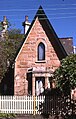
 Sze Yup Chinese Temple
 -
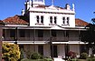
 Toxteth Lodge
 -
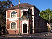 Record Reign Hall, St Johns Road
 -
 Glebe Town Hall


Churches
St Johns Anglican Church, St James Catholic Church. The Abbey is a former church site awaiting redevelopment.
-
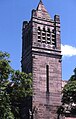 St John's Church, designed by Edmund Blacket
 -
 St James Catholic Church
 -
 St James Catholic School
 -
 St Scholastica's College


Education
Schools in the suburb include Glebe Public School (on Glebe Point Road), St James Catholic School (on Woolley Street), Forest Lodge Public School (Pyrmont Bridge Rd) and St Scholastica's College (on Avenue Road). The Blackwattle Bay Campus of Sydney Secondary College sits on the site of the old Glebe High School.
The Bedford College, a vocational college which offers diplomas and certificates in the fields of Business and Child Care is in Glebe.
Culture


Glebe markets
Glebe has a popular market which is held on Saturdays in the grounds of Glebe Primary School. Arts, crafts, clothing and edibles are sold. They are known as the alternative markets for the alternative lifestyle goods that are offered. New and pre-loved goods are sold here.
Restaurants
Glebe is well-known for its variety of ethnic restaurants, possibly the most diverse in Sydney, which are located along Glebe Point Road. As well as the usual Indian, Thai, Italian etc. can be found Nepalese, Dutch-Indonesian, and other minority ethnic tastes.
Sport and recreation
Harold Park Paceway is a harness racing track in Glebe. The NSW Harness Racing Club is located in Ross Street. Wentworth Park, which features a greyhound racing track, is on the border with Ultimo.
Glebe mini skateboarding ramp is located in Bicentennial Park off Chapman road, in between Glebe and Annandale. The mini was originally 3.5-foot (1.1 m) tall with a hump in the middle. Circa 2005 the original mini was removed and replaced with a traditional 4-foot (1.2 m) ramp, sans hump.
Houses
19th century housing stock is largely intact, having undergone restoration as a result of gentrification. It is popular with city-workers and students due to its proximity to the University of Sydney and University of Technology Sydney. Glebe is popular with backpackers as the suburb has many conveniences and is served by tram and a regular bus route.
At its south-eastern end is the Glebe Estate, an area of Housing Commission properties purchased by the government of Gough Whitlam to provide public housing for the needy. This area today has the third highest Aboriginal population in Sydney.[7]
Notable residents
- David Musgrave, an award winning poet
- Reg Mombassa (the pseudonym of Chris O'Doherty), artist and musician
- Leo Sayer, a well-known singer/songwriter of the 1970s
References
- ^ The Book of Sydney Suburbs, Compiled by Frances Pollon, Angus & Robertson Publishers, 1990, p.109
- ^ Sydney Architecture, John Haskell (UNSW Press) 1997, p.62
- ^ Heritage of Australia, Macmillan Publishing Company, 1981, p.2/38
- ^ The NSW Women’s Refuge Movement’s Little Book of Refuges- First Edition
- ^ Sze Yup Buddhist temple set alight in Glebe | The Daily Telegraph
- ^ The Heritage of Australia, Macmillan Company, 1981, pp. 2/38-2/39
- ^ Template:PDF, page 3
External links
- The Glebe Society
- GlebeNet: Information for Residents and Tourists
- City of Sydney: Glebe, Forest Lodge and Broadway