
Mercer Island, Washington
Mercer Island, Washington | |
|---|---|
 Aerial view of Mercer Island surrounded by Lake Washington. | |
| Nickname: MI | |
 Location of Mercer Island in King County, Washington | |
| Country | United States |
| State | Washington |
| County | King |
| Area | |
| • Total | 13.11 sq mi (33.95 km2) |
| • Land | 6.32 sq mi (16.37 km2) |
| • Water | 6.79 sq mi (17.59 km2) |
| Elevation | 338 ft (103 m) |
| Population | |
| • Total | 22,699 |
| • Estimate (2012[3]) | 23,661 |
| • Density | 3,591.6/sq mi (1,386.7/km2) |
| Time zone | UTC-8 (Pacific (PST)) |
| • Summer (DST) | UTC-7 (PDT) |
| ZIP code | 98040 |
| Area code | 206 |
| FIPS code | 53-45005 |
| GNIS feature ID | 1512455Template:GR |
| Website | www.mercergov.org |

Mercer Island is a city in King County, Washington, United States and the name of the island in Lake Washington on which the city sits. The population was 22,699 at the 2010 census.[4] The population was 22,720 at 2013 Estimate from Office of Financial Management.
Located in the Seattle Metropolitan Area,[5] it is the most populated island in a lake within the United States.[6] The ZIP code 98040 is unique to Mercer Island.[7]
History
Mercer Island, named for the Mercer family of Seattle, was first settled between 1870 and 1880. The Mercer brothers often rowed between the island and Seattle to pick berries, hunt, and fish. Those brothers, Thomas Mercer and Asa Shinn Mercer, are members of the Mercer family of Virginia. The first large settlement, East Seattle, was toward the northwest side of the island—near the McGilvara neighbourhood. During 1889, a C C Calkins built a large and gilded resort, the Calkins Hotel. The hotel was reached via steamboat between Madison Park, Leschi Park, and the Eastside. Burnt by a mysterious fire, the hotel was razed during 1908.
The Calkins Landing continued service and presumedly aided location of a more permanent population. A denser urban community with business district developed toward the central northern island between the McGilvara neighborhood and Luther Burbank Park. This community now composes the majority of the island's crest through the Middle Island neighborhood.
In 1928, the East Channel Bridge was built to connect the island with Bellevue, Washington. In 1930, George W Lightfoot requested a bridge between Mercer Island and Seattle. The Lacey V Murrow Memorial Bridge, currently the second longest floating bridge on Earth, was built and opened in 1940. In 1989, a second bridge, the Homer M Hadley Memorial Bridge, was built parallel to the Lacey V Murrow Memorial Bridge. The East Channel Bridge, Lacey V Murrow Memorial Bridge, and Homer M Hadley Memorial Bridge, carry Interstate 90 from Seattle, through Mercer Island, and into Bellevue. (Another floating bridge, the Governor Albert D Rosellini Bridge—Evergreen Point, was built across Lake Washington in 1963, north of Mercer Island. It connects Seattle and Medina.)
The island was mentioned on the hit TV show Frasier, which was set in Seattle. The reference depicted it as being dinky and unimportant. Frasier, at the time, was trying to find a good agent to publicize his radio show. He discovered a good candidate who had done publicity work for the fictional Mercer Island Zoo. Character Daphne Moon implied he had done poorly at achieving notoriety for the zoo, remarking, "There's a zoo on Mercer Island now?"
The City of Mercer Island was incorporated from East Seattle on 5 July 1960 and composed of all the island less the 70 acre (280,000 m²) business district. Just over one month later, 9 August, the Town of Mercer Island was incorporated from that business district. The two aforementioned municipalities merged as the City of Mercer Island 19 May 1970.
Geography
Mercer Island is located at 47°34′9″N 122°13′56″W / 47.56917°N 122.23222°W (47.569271, -122.232337).Template:GR
According to the United States Census Bureau, the city has a total area of 13.11 square miles (33.95 km2), of which, 6.32 square miles (16.37 km2) is land and 6.79 square miles (17.59 km2) is water.[1]
Mercer Island is the largest populated island in a lake in the US. [8]
Education
The Mercer Island School District overviews six common schools on the island: three primary schools (Lakeridge Elementary, Island Park Elementary and West Mercer Elementary); one Middle school (Islander Middle School); one High school (Mercer Island High School); one alternative secondary school (Crest Learning Center).
Mercer Island is also home to the St. Monica School(K-8), the French American School of Puget Sound (P-8), and the Northwest Yeshiva High School (9-12).
Demographics
| Census | Pop. | Note | %± |
|---|---|---|---|
| 1970 | 19,819 | — | |
| 1980 | 21,522 | 8.6% | |
| 1990 | 20,816 | −3.3% | |
| 2000 | 22,036 | 5.9% | |
| 2010 | 22,699 | 3.0% | |
| 2012 (est.) | 23,661 | 4.2% | |
2012 Estimate[10] | |||
The median income for a household in the city was $151,904, and the median income for a family was $190,830. The average household income in 2004 was $169,841.[11] The per capita income for the city was $123,799. About 0.9% of families and 0.2% of the population were below the poverty line, including 3.4% of those under age 18 and 2.3% of those age 65 or over.
As of 2011, the 98040 ZIP code had a median house sale price of $1,001,405, placing it at #209 in a list of the most expensive ZIP codes in America,[12] including a sale of a property for $26.9 million.[citation needed]
Washington State's Office of Financial Management also publishes per-county, per-city population statistics of its own. Its 2013 estimate was 22,720.[13]
2010 census
As of the census[2] of 2010, there were 22,699 people, 9,109 households, and 6,532 families residing in the city. The population density was 3,591.6 inhabitants per square mile (1,386.7/km2). There were 9,930 housing units at an average density of 1,571.2 per square mile (606.6/km2). The racial makeup of the city was 77.9% White, 1.3% African American, 0.2% Native American, 15.9% Asian, 0.1% Pacific Islander, 0.7% from other races, and 3.9% from two or more races. Hispanic or Latino of any race were 2.8% of the population.
There were 9,109 households of which 33.5% had children under the age of 18 living with them, 62.3% were married couples living together, 6.5% had a female householder with no husband present, 2.9% had a male householder with no wife present, and 28.3% were non-families. 24.1% of all households were made up of individuals and 11.8% had someone living alone who was 65 years of age or older. The average household size was 2.48 and the average family size was 2.97.
The median age in the city was 46 years. 24.6% of residents were under the age of 18; 4.8% were between the ages of 18 and 24; 19% were from 25 to 44; 32% were from 45 to 64; and 19.5% were 65 years of age or older. The gender makeup of the city was 48.7% male and 51.3% female.
2000 census
As of the census of 2000, there were 22,036 people, 8,437 households, and 6,277 families residing in the city. The population density was 3,452.0 inhabitants per square mile (1,333.6/km²). There were 8,806 housing units at an average density of 1,379.5 per square mile (532.9/km²). The racial makeup of the city was 84.09% White, 1.14% African American, 0.16% Native American, 11.87% Asian, 0.07% Pacific Islander, 0.52% from other races, and 2.16% from two or more races. Hispanic or Latino of any race were 1.86% of the population.
There were 8,437 households out of which 35.5% had children under the age of 18 living with them, 65.6% were married couples living together, 6.7% had a female householder with no husband present, and 25.6% were non-families. 22.1% of all households were made up of individuals and 11.2% had someone living alone who was 65 years of age or older. The average household size was 2.58 and the average family size was 3.03.
In the city the population was spread out with 26.0% under the age of 18, 4.2% from 18 to 24, 21.2% from 25 to 44, 29.9% from 45 to 64, and 18.7% who were 65 years of age or older. The median age was 44 years. For every 100 females there were 92.7 males. For every 100 females age 18 and over, there were 88.3 males.
Parks
Luther Burbank Park covers 77 acres (310,000 m2) of land and has 0.75 miles (1.2 km) of waterfront. The park has a public boat dock and fishing pier, a swimming beach, an amphitheater, tennis courts, barbecues and picnic facilities, and an off-leash dog area.[14] The city assumed maintenance of the park on January 1, 2003 from King County, which had purchased the park land in 1969.[15]
The Park on the Lid is atop the I-90 tunnel entrances. This park has softball fields, tennis courts, basketball courts, picnic shelters, and the Freeway Sculpture Park. [16] [17]
Pioneer Park covers 113 acres (0.46 km2) and has equestrian, bicycle, and hiking trails.[18] Deane's Children Park, also known as "Dragon Park", is a small park with playground equipment.[19]
Mercer Island also has many smaller parks maintained by the city, some of which have waterfront access.
Sister cities
Mercer Island's sister city, as designated by Sister Cities International, is Thonon-les-Bains, France.[20][21]
Annual events
- Mercer Island is focal to annual performances by the Blue Angels during Seattle's summer Seafair celebration. However, the Blue Angels will not be included in the 2013 celebration.[citation needed]
- Summer Celebration is a celebration once a year on the weekend after the 4th of July. The celebration ends with fireworks.[22]
Pictures
-
 Luther Burbank Park
 -
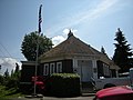 Keewaydin Clubhouse
 -
 Luther Burbank Park docks
 -
 Luther Burbank School


References
- ^ a b "US Gazetteer files 2010". United States Census Bureau. Retrieved 2012-12-19.
- ^ a b "American FactFinder". United States Census Bureau. Retrieved 2012-12-19.
- ^ "Population Estimates". United States Census Bureau. Retrieved 2013-06-01.
- ^ "2010 Census Redistricting Data (Public Law 94-171) Summary File". American FactFinder. United States Census Bureau. Retrieved 23 September 2012.
- ^ Update of Statistical Area Definitions and Guidance on Their Uses, Office of Management and Budget, 2007-11-20. Accessed 2008-12-10.
- ^ "Demographics".
- ^ "United States Postal Service "ZIP Code Lookup"".
- ^ http://www.worldislandinfo.com/US%20Island%20Superlatives.html.
{{cite web}}: Missing or empty|title=(help) - ^ United States Census Bureau. "Census of Population and Housing". Retrieved July 31, 2013.
- ^ "Annual Estimates of the Resident Population: April 1, 2010 to July 1, 2012". Retrieved July 31, 2013.
- ^ Mercer Island Chamber of Commerce. "Community Information" url=http://www.mercerislandchamber.com/Community/Community+Info/
- ^ "Most Expensive ZIP Codes 2011". Forbes. Retrieved 2012-08-03.
- ^ "April 1, 2013 Population of Cities, Towns and Counties Used for Allocation of Selected State Revenues State of Washington" (PDF). 1 April 2013. Retrieved 31 July 2013.
- ^ "Luther Burbank Park". City of Mercer Island. Retrieved 2009-03-09.
- ^ "History". City of Mercer Island. Retrieved 2009-03-09.
- ^ "Park on the Lid". City of Mercer Island. Retrieved 2009-03-09.
- ^ Morris, Keiko (1998-02-23). "A Sculpture Garden Grows On Island `Lid'". Seattle Times. Retrieved 2009-03-11.
- ^ "Pioneer Park". City of Mercer Island. Retrieved 2009-03-10.
- ^ "Deane's Children Park". City of Mercer Island. Retrieved 2009-03-11.
- ^ "Sister Cities International". Retrieved 2012-08-01.
- ^ Mercer Island Sister City Association
- ^ "City of Mercer Island - Summer Celebration! Homepage". Retrieved 2012-08-02.
External links
- Mercer Island Reporter Local newspaper
Municipalities and communities of King County, Washington, United States | ||
|---|---|---|
| Cities |
|  |
| Towns | ||
| CDPs |
| |
| Other communities | ||
| Indian reservation | ||
| Ghost towns | ||
| Footnotes | ‡This populated place also has portions in an adjacent county or counties | |