Manila American Cemetery
| Manila American Cemetery and Memorial | |
|---|---|
| American Battle Monuments Commission | |
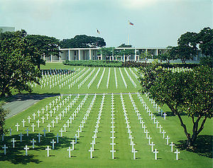
 Manila American Cemetery headstones with memorial building behind. | |
| Used for those deceased 1941 - 1945 | |
| Established | 1948 |
| Location | 14°32′28″N 121°03′00″E / 14.541°N 121.050°E near |
| Designed by | Gardener A. Dailey |
| Total burials | 17,206 |
Unknowns | 3,744 |
| Burials by nation | |
* United States: 16,636
| |
| Burials by war | |
* World War II: 17,206 | |
| Statistics source: American Battle Monuments Commission | |
The Manila American Cemetery and Memorial is located in the Fort Bonifacio, Taguig City, Metro Manila, within the boundaries of the former Fort William McKinley. It can be reached most easily from the city by taxi or automobile via Epifano de los Santos Ave. (EDSA) to McKinley Road, then to McKinley Parkway inside the Bonifacio Global City. The Nichols Field Road is the easiest access from Manila International Airport to the cemetery. [1]
The cemetery, 152 acres (62 ha) or 615,000 square metres in area, is located on a prominent plateau, visible at a distance from the east, south and west.[1] With a total of 17,206 graves, it has the largest number of graves of any cemetery for U.S. personnel killed during World War II and holds war dead from the Philippines and other allied nations.[1] Many of the personnel whose remains are interred or represented were killed in New Guinea, or during the Battle of the Philippines (1941-42) or the Allied recapture of the islands.[1] The headstones are made of marble which are aligned in eleven plots forming a generally circular pattern, set among a wide variety of tropical trees and shrubbery.[1]
The Memorial is maintained by the American Battle Monuments Commission. It is the largest site administered by the Commission in the number of graves and of those missing whose names are recorded on the walls of the memorial.
The cemetery is open daily to the public from 9:00 a.m. to 5:00 p.m. except December 25 and January 1.[1]
General layout
The entrance to the cemetery is at the far (north) side of the large grassed circle just beyond the military sentinel's post which is at the junction of McKinley Road and Lawton Avenue (formerly Nichols Field Road). Immediately beyond the gate is the plaza with its circular fountain; at the right is the Visitors' Building. Stretching from the plaza to the memorial is the central mall, which is lined with mahogany trees (Swietenia Macrophylla). Circular roads leading eastward and westward through the graves area join the straight roads along the edges of the mall. To the east of, and lower than, the graves area are the service area, deep wells and reservoirs. A purification system provides potable water within the cemetery.
The memorial

Twenty-five large mosaic maps in four rooms recall the actions of the United States Armed Forces in the Pacific, China, India and Burma.[1]
Carved in the floors are the seals of the American states and its territories.[1]
