
Golan Heights
The Golan Heights (Hebrew: רמת הגולן Ramat HaGolan, Arabic: هضبة الجولان HaTemplate:ArabDINbat al-Template:ArabDINūlān) or Golan, formerly also known as the Syrian Heights,[1][2] is a plateau on the border of Israel, Lebanon, Jordan and Syria.
The name "Golan" is a polysemy that refers to the historical name of a geographic region, and in contemporary usage may serve as a political designation applying to territory annexed to Israel from Syria. (See Names and their applications below).
Israel captured the Heights from Syria in the 1967 Six-Day War (and again in the 1973 Yom Kippur War). In 1981, Israel applied its "laws, jurisdiction and administration" in the Golan Heights with the Golan Heights Law. Syria asserts that the Heights are part of the governorate of al Qunaytirah. The United Nations resolutions, including 242, consider the area under Israeli occupation from which Israel should withdraw (extent disputed) under a peace treaty. (See Current status below). Syria, however, has not expressed willingness in making peace with Israel in return for the Heights.[3]
Names and their applications
Clarification of the name "Golan" is warranted since:
- "Golan" is a polysemic toponym, its different meanings referring to areas that are not conterminous
- numerous additional names, variants derived from "Golan" are employed in specific contexts.
The origin of the name "Golan" is from an ancient city mentioned in the Bible as a "City of Refuge" (also see Golan). Eventually, Golan became known as the name of an informal geographic region stretching from that ancient place west towards the Sea of Galilee. Additional names used in this context are Gaulanitis or Gaulonitis.
That historic name has been applied over the past century to the geographic-geological plateau characterized by its basalt stone and its dark soil. This definition refers to the area bordered by the Jordan Valley to its west, the Yarmuk River to its south and the Sa'ar River to its north. The Sa'ar River divides between the dark-soiled volcanic Golan and the distinct white limestone of Mount Hermon. Additional names used in this context are Gaulan and Jaulan. The region also lent its geographic name to a breed of cattle native to the area. the Jaulan
The name "Golan" has been adopted in Israeli culture to refer to that territory taken by Israel from Syria. The territory taken does not include all of the geographic or historic Golan; furthermore it does include areas belonging to other geographic regions, such as the Hermon and the Jordan Valley. The boundries of that territory are somewhat less rigid than the geographic definition; a sizable portion of the area conquered by Israel in 1967 was ceded to Syria after the Yom Kippur War.
Geography


Geographically, the Heights are bordered on the west by a rock escarpment that drops 1,700 feet (500 m) to the Sea of Galilee and the Jordan River; on the south by the Yarmouk River; on the north by the international border with Lebanon, and on the east by a largely flat plain, called the Hauran. The Golan is usually divided into three regions: northern (between Nahals Sa'ar and Gilabon), central (between Nahals Gilabon and Dilayot), and southern (between Nahal Dilayot and the Yarmouk Valley). The Golan Heights themselves are between 400 and 1,700 feet (120–520 m) high.
Geologically, the Golan Heights are a plateau, and part of a Holocene volcanic field that extends northeast almost to Damascus. The entire area is scattered with inactive cinder cones such as Majdal Shams. Mount Hermon is in the northern Golan Heights but is geologically separate from the volcanic field. Near Hermon is a crater lake called Birkat Ram ("Ram Pool") which is fed by underground springs.
Current status
The Israeli army captured the Heights and put it under military administration from 1967 until 1981, when the Knesset passed "The Golan Heights Law" [1], similar to its 1967 measures concerning Jerusalem. Most of the Arab residents of the Golan Heights, mainly Druze, are Syrian Arabs who retain their Syrian citizenship even though Israeli citizenship is available to them. Syria continues to offer them some benefits such as free university tuition.
In 2006 the Golan Heights had a population of approximately 36,000 people, consisting of approximately 19,000 Jewish settlers and 17,000 Druze residents. [2] The Jewish villages, including moshavim and kibbutzim, are consolidated municipally under the Golan Regional Council.
Israel's measures are frequently termed "annexation" but the word "annexation" or equivalent concepts, like "extending sovereignty," are not used in the law itself. In any case, the result of the extension of sovereignty/annexation has been an end to the application of military regulations to the populace. It has also been noted that the Golan Heights have been a part of peace negotiations between Syria and Israel.
When Israeli Prime Minister Menachem Begin was asked in the Knesset why he was risking international criticism for this annexation, he replied "You use the word annexation, but I am not using it."[3] The governmental Jewish Agency for Israel states that "Although reported as a annexation, it is not: the Golan Heights are not declared to be Israeli territory."[4] On the other hand, the Benjamin Netanyahu government's Basic Policy Guidelines stated "The government views the Golan Heights as essential to the security of the state and its water resources. Retaining Israel's sovereignty over the Golan will be the basis for an arrangement with Syria."[5] Neither the UN nor any country has recognised the "annexation" and they officially consider the Heights to be Syrian territory under Israeli military occupation. This view was expressed in the unanimous UN Security Council Resolution 497 stating that "the Israeli decision to impose its laws, jurisdiction and administration in the occupied Syrian Golan Heights is null and void and without international legal effect." It, like other relevant UN resolutions takes care to not explicitly call it an "annexation", referring at most to Israel's "annexationist policies."
Additionally, Lebanon claims a small portion of the area known as Shebaa Farms on Mount Dov in the area of Mount Hermon. Syria's position on the subject is unclear. Syria's foreign minister has orally declared that the Shebaa farms are Lebanese, but Syria has refused to notify the UN of its position officially. Thus, from the UN perspective, Shebaa remains Syrian until the Syrian government confirms its position through official channels. UN Security Council Resolution 425 confirmed [6] that as of June 16 2000, Israel had completely withdrawn its forces from Lebanon, thereby indirectly designating the farms as part of the Golan, and therefore Syrian territory. The reason behind this diplomatical imbroglio is that Syria fears that recognizing the Shebaa territory as Lebanese will allow Lebanon to negotiate a separate deal with Israel.
UNDOF (the United Nations Disengagement Observer Force) was established in 1974 to supervise the implementation of the disengagement agreement and maintain the ceasefire with an area of separation known as the UNDOF Zone. Currently there are more than 1,000 UN peacekeapers there trying to sustain a lasting peace. Syria and Israel still contest the ownership of the Heights but have not used overt military force since 1974. The great strategic value of the Heights both militarily and as a source of water means that a deal is uncertain.
Members of the UN Disengagement force are usually the only individuals who cross the Israeli-Syrian border, but since 1988, Israel has allowed Druze pilgrims to cross the border to visit the shrine of Abel in Syria. In 2005, Syria allowed a few trucks of Druze-grown Golan apples to be imported. The trucks themselves were driven by Kenyan nationals. Since 1967, brides have been allowed to cross the Golan border, but they do so in the knowledge that the journey is a one-way trip. This phenomenon is shown in the Israeli-Arab film The Syrian Bride. The Golan Heights contains the only ski resort under Israeli control [7], and the extreme-weather unit of the IDF, the Alpinistim, train there.
Some Jews and Zionist organizations consider the Golan Heights to be liberated Jewish land; this view has very little support internationally. No other country has formally accepted the legality of the Israeli settlements in the Golan Heights.
Following the Knesset's approval of the law, Professor Julius Stone of Hastings College of the Law wrote: "There is no rule of international law which requires a lawful military occupant, in this situation, to wait forever before [making] control and government of the territory permanent....Many international lawyers have wondered, indeed, at the patience which led Israel to wait as long as she did." (Near East Report, January 29, 1982)
History


Ancient history
The area has been occupied by many civilizations. During the 3rd millennium BC the Amorites dominated and inhabited the Golan until the 2nd millennium, when the Arameans took over. Later known as Bashan, the area was contested between Kingdom of Israel (the northern of the two Jewish kingdoms existent at that time) and the Aramean kingdom from the 800s BC. King Ahab of Israel (reigned 874–852 BC) defeated Ben-Hadad I in the southern Golan.
In the 700s BC the Assyrians gained control of the area, but were later replaced by the Babylonian and the Persian Empire. In the 5th century BC, the region was settled by returning Jewish exiles from Babylonian Captivity.
The Golan Heights, along with the rest of the region, came under the control of Alexander the Great in 332 BC, following the Battle of Issus. Following Alexander's death, the Golan came under the domination of the Macedonian noble Seleucus and remained part of the Seleucid Empire for most of the next two centuries. It is during this period that the name Golan, previously that of a city mentioned in Deuteronomy, came to be applied to the entire region (Greek: Gaulanitis).
The Maccabean Revolt saw much action in the regions around the Golan and it is possible that the Jewish communities of the Golan were among those rescued by Judah Maccabee during his campaign in the Galilee and Gilead (Transjordan) mentioned in Chapter 5 of 1 Maccabees. The Golan, however, remained in Seleucid hands until the campaign of Alexander Jannaeus from 83-80 BC. Jannaeus established the city of Gamla in 81 BC as the Hasmonean capital for the region.
Following the death of Herod the Great in 4 BC, Augustus Caesar adjudicated that the Golan fell within the Tetrarchy of Herod's son, Herod Philip. After Philip's death in 34 AD, the Romans absorbed the Golan into the province of Syria, but Caligula restored the territory to Herod's grandson Agrippa in 37. Following Agrippa's death in 44, the Romans again annexed the Golan to Syria, promptly to return it again when Claudius traded the Golan to Agrippa II, the son of Agrippa I, in 51 as part of a land swap. Although nominally under Agrippa's control and not part of the province of Judea, the Jewish communities of the Golan joined their coreligionists in the First Jewish-Roman War, only to fall to the Roman armies in its eary stages. Gamla was captured in 67; according to Josephus, its inhabitants committed mass suicide, preferring it to crucifixion and slavery. Agrippa II contributed soldiers to the Roman war effort and attempted to negotiate an end to the revolt. In return for his loyalty, Rome allowed him to retain his kingdom, but finally absorbed the Golan for good after his death in 100.
In about 250, the Ghassanids, Arab Christian immigrants from Yemen, established a kingdom which encompassed southern Syria and the Transjordan, building their capital at Jabiyah on the Golan. Like the later Herodians, the Ghassanids ruled as clients of Byzantine Rome; unlike the Herodians, the Ghassanids were able to hold on to the Golan until the Sassanid invasion of 614. Following a brief restoration under the Emperor Heraclius, the Golan again fell, this time to the invading Arabs after the Battle of Yarmouk in 636.
After Yarmouk, Muawiyah I, a member of Muhammad's tribe, the Quraish, was appointed governor of Syria, including the Golan. Following the assasination of his cousin, the Caliph Uthman, Muawiya claimed the Caliphate for himself, initiating the Umayyad dynasty. Over the next few centuries, while remaining in Muslim hands, the Golan passed through many dynastic changes, falling first to the Abbasids, then to the Shi'ite Fatimids, then to the Seljuk Turks, then to the Kurdish Ayyubids. During the Crusades, the Heights represented a formidable obstacle the Crusader armies were not able to conquer. The Mongols swept through in 1259, but were driven off by the Mamluk sultan Qutuz at the Battle of Ain Jalut in 1260. Ain Jalut ensured Mamluk dominance of the region for the next 250 years.
In the 15th and 16th centuries, Druze began to settle the northern Golan and the slopes of Mount Hermon. In the 16th century, the Ottoman Turks came in control of the area and remained so until the end of World War I.
In 1894, a Jewish community called Ramataniya was founded by Baron Edmond James de Rothschild, a French Jew and early Zionist; however, the community failed within a year.
Between World War I and the Six-Day War

The boundary between the forthcoming British and French mandates was defined in broad terms by the Franco-British Boundary Agreement of December 1920. The demarcation was completed March 7, 1923, several months before Britain and France assumed their Mandatory responsibilities.[8] This placed most of the Golan in the French sphere. In accordance with the same process, a nearby parcel of land that included the ancient site of Dan was transferred from Syria to Palestine early in 1924. The Golan Heights thus became part of the French Mandate of Syria and, when that mandate ended in 1944, part of the new independent state of Syria. They remained under Syrian control until 1967.
After the 1948-49 Arab-Israeli War, the Golan Heights were partly demilitarized by the Israel-Syria Armistice Agreement. Over the following years the Mixed Armistice Commission (which oversaw the implementation of the Israel-Syria Armistice Agreement) reported many violations by each side, however, the first violation had come from Syria. The Syrians fortified positions on the Heights, from which they shelled civilian targets in Israel and launched other attacks for the next 18 years. Syria and used the Heights as a military stronghold from which its troops randomly sniped at Israeli civilians in the Hula Valley. In some cases, Syria had permitted Yasser Arafat's Fatah to operate in their territory. Subsequently, Israel took the situation to the UN in October 1966 to demand a halt to Fatah attacks. "It is not our duty to stop them, but to encourage and strengthen them," the Syrian ambassador responded.[4]
Before the Six-Day War the strategic heights of the Golan, which are approximately 3,000 feet (1,000 m) above pre-1967 Israel, were used to frequently bombard civilian Israeli farming communities far below them, although Moshe Dayan (Israeli Defense Minister during the 1967 war) would later state that it was most often the result of Israeli provocations in the demilitarized zone. According to the Washington Report on Middle East Affairs, former Israeli General Mattityahu Peled claimed that more than half of the border clashes before the 1967 war "were a result of our security policy of maximum settlement in the demilitarized area"[9].

140 Israelis were killed and many more were injured in these attacks from 1949 to 1967.

During the Six-Day War of 1967 Syria's shelling greatly intensified and the Israeli army captured the Golan Heights on 9-10 June. The area which came under Israeli control as a result of the war is two geologically distinct areas: the Golan Heights proper (413 sq mi; 1,070 km²) and the slopes of the Mt. Hermon range (39 sq mi; 100 km²).
History since the Six-Day War
About 90% (80,000) of the Golan's inhabitants, mainly Druze Arabs and Circassians, fled or were expelled by Israeli forces during the Six-Day War.[5] For various political and security reasons, Israel has not allowed those who fled to return [10].
Israel began settling the Golan almost immediately following the war. Kibbutz Merom Golan was founded in July 1967. By 1970 there were 12 Jewish settlements on the Golan and in 2004 there were 34 settlements populated by around 18,000 people [11]. Today the Golan is firmly under Israeli control as part of the Jewish state.

During the Yom Kippur War in 1973, Syrian forces overran much of the southern Golan, before being pushed back by an Israeli counterattack. Israel and Syria signed a ceasefire agreement in 1974 that left almost all the Heights in Israeli hands, while returning a narrow demilitarized zone to Syrian control.
The Syrian citizens who remained in the area after it was captured by Israel in 1967 were required to carry Israeli military identity papers. In the late 1970s, the Likud government of Israel began pressuring them to request Israeli citizenship by tying it to privileges such as the right to obtain a drivers licence or to travel in Israel. In March 1981, the community leaders imposed a socio-religious ban on Israeli citizenship. Protests came to a head after the November 1981 annexation (or effective annexation, see above) of the Golan Heights by Israel. They included a general strike that lasted for five months and demonstrations that sometimes became violent. The Israeli authorities responded by suspending habeus corpus, imprisoning the protest leaders and imposing curfews and other restrictions. On April 1, 1982, a 24-hour curfew was imposed and soldiers went from door to door confiscating the old ID cards and replacing them with cards signifying Israeli citizenship. This action caused an international outcry including two condemnatory UN resolutions [12] [13]. Israel eventually relented and permitted retention of Syrian citizenship, as well as agreeing not to enforce the mandatory draft.
Syria has always demanded a full Israeli withdrawal from all of the Golan Heights, to the shoreline of the Sea of Galilee (the 1967 line, including land occupied by Syria on the east shore of the Sea of Galilee during the years 1949-1967). Successive Israeli governments have expressed support for some Israeli withdrawal from the Golan without specifying the extent of this withdrawal. In return for this withdrawal, Israel demands that the area of the Golan falling under Syrian control become demilitarized and that other security measures are implemented to prevent a potential surprise Syrian attack.

Israel has always insisted that any agreement with Syria must include fully normalized diplomatic and economic relations. Prior to the 2000 negotiations, Hafez al-Assad did not offer travel and trade rights to Israelis, but in the 2000 negotiations he did agree to a peace deal of the same nature that Egypt and Jordan made.
In a memorandum for the Secretary of Defense from the Joint Chiefs of Staff, June 29, 1967:
“From a strictly military point of view, Israel would require the retention of some captured territory in order to provide militarily defensible borders.”
Regarding the Golan Heights, Yitzhak Rabin stated:
Words are not enough about the Golan Heights. We must put them into actions... Withdrawal from the Golan is unthinkable, even in times of peace. Anyone considering withdrawal from the Golan Heights would be abandoning Israel’s security. Let us invest, all of us together, in order to fulfil our obligations to the Golan Heights. And to you residents — those who made the Golan Heights what it is — you have all my respect.
When interviewed about an upcoming conference on American TV network ABC on September 16, 1991, Syrian president Hafez al-Assad said:
The efforts currently exerted are based on the Security Council Resolutions № 242 and № 338 on the basis of realizing a comprehensive peace in the region. The Golan, as an occupied Syrian territory, shall be reinstated, within the framework of such comprehensive peace, to its natural status as part of Syrian territory. Upon implementing the comprehensive solution for the two Arab and Israeli sides, comprehensive peace will prevail and documents will be achieve peace process. This as you know will be decided within the Conference, the Israeli side on the one hand and the Arab side on the other.
Also regarding the Heights, when asked about military conflict in the area, Moshe Dayan stated :
It would happen like this: We would send a tractor to plow someplace of no value, in the demilitarized zone, knowing ahead of time that the Syrians would begin to shoot. If they did not start shooting, we would tell the tractor to keep going forward, until the Syrians in the end would get nervous and start shooting. And then we would start firing artillery, and later also the airforce, and this was the way it was. I did this, and Laskov and Tzur [two previous commanders-in-chief] did it. Yitzhak Rabin did it when he was there , but it seems to me that it was Dado, more than anyone else, who enjoyed these games.
However, Dayan also noted regarding the Israeli farmers who lived at the base of the Heights:
They suffered a lot because of the Syrians. Look, as I said before, they lived in the kibbutzim, they farmed, raised children, lived and wanted to live there. The Syrians opposite them were soldiers who shot at them and they certainly did not like this. But I can tell you in absolute certainly: the delegation that came to convince Eshkol to attack the Heights did not think about these things. It thought about the land on the Heights. Listen, I am also a farmer. I'm from Nahalal, not from Tel Aviv, and I recognize this. I saw them, and I talked to them. They did not even try to hide their greed for that soil. That's what guided them.
During United States-brokered negotiations in 1999-2000, Israel offered to withdraw to the Green line in exchange for peace and full recognition. Syria refused and demanded the additional strip of shore that was taken by force from Israel between 1949-1967, anchored in Assad's famous speech about his memories of bathing in the Sea of Galilee. Syria offered full recognition and peace in exchange for a complete return to the pre-1967 borders, and as that ment Syrian control of Israel's only sweet water sea, Israel refused.
In late 2003, Syrian President Bashar al-Assad said he was ready to revive peace talks with Israel. Israel demanded Syria first disarm Hezbollah, who launched many attacks on northern Israeli towns and army posts from Syrian and Lebanese territory. Peace talks were not initiated. The population currently resident in the Golan is, 40% Druze and 60% Jewish.
Although the Golan Heights has generally been a peaceful area, a number of Golan residents from Majdal Shams have been jailed by the Israeli authorities for involvement in armed activities against Israel. [14].
In general, Golan Jewish residents are closer to the Israeli mainstream in terms of political alignment than Jewish residents of the West Bank. Jewish settlers on the Golan are called "mityashvin" - which has a ring of "pioneers", whereas Jewish settlers on the West Bank and Gaza are and were called "mitnachalim" which has a negative connotation in many Israelis' minds.[citation needed]
Towns and villages
The Golan Heights' administrative center, which is also its largest Israeli community, is the town of Qatzrin, built in the 1970s. There are another 19 moshavim and 10 kibbutzim.
There are also four Druze and Circassian villages in the Northern part of the Golan Heights including Majdal Shams, and an Alawite village called Ghajar that stretches on both side of the Lebanese-Israeli border.
Attractions
Qatzrin
Qatzrin is regarded as "the capital of the Golan Heights" and as such hosts a large number of attractions. The ancient Talmudic village of Qisrin is fully excavated and one can tour the different houses in the village as well as the remains of a large synagogue. There is also an interactive movie experience about the Talmudic time within the compound. The Museum of Golan Antiquities hosts archaeological finds uncovered in the Golan Heights from prehistoric times. A special focus concerns Gamla and excavations of synagogues and Byzantine churches. Throughout the Golan Heights 29 ancient synagogues were found dating back to the Roman and Byzantine periods. Qatzrin is home to the Golan Heights Winery, a major winery of Israel and the mineral water plant of Mey Eden which derives its water from the spring of Salukiya in the Golan. One can tour these factories as well as factories of oil products and fruit products. It also has two open air strip malls one which holds the Kesem Hagolan or the "Golan Magic" a three-dimentional movie and model of the geography and history of the Golan Heights [15] [16] [17].
Gamla Nature Reserve
The Gamla Nature Reserve is an open park which holds the archaeological remains of the ancient city of Gamla - including the tower, the wall and the synagogue. It's also the site of a large waterfall, an ancient Byzantine church, and a panoramic spot to observe the 100 eagles who dwell in the cliffs. Israeli scientists in the place observe the life of the eagles and tourists can watch them fly and nest. [18]
Gilgal Refaim
A large impressive circular stone monument, similar to the famous Stonehenge. This monument can best be seen from the air due to its size. A 3D model of the site exists in the Museum of Golan Antiquities in Qatzrin.
Um el Kanatir
Um el Kanatir is another impressive Byzantine archeological site. The site includes a very large synagogue and two arcs next to a water source. [19] The arcs have been dubbed Rehavam Arcs after Rehavam Zeevi [20][21].
Nimrod Fortress
An ancient fortress used by the Ayyubids, Crusaders, the Mongols and Mamluks in many fierce battles. This is now a nature reserve open for exploring.
Mount Hermon
The slopes of Mount Hermon in the Golan Heights house an Israeli ski resort including a wide range of ski trails at novice, intermediate, and expert levels. It also offers additional winter family activities such as sled-riding and Nordic skiing. Those who operate the Hermon Ski area live in the nearby moshav of Neve Ativ and the town of Majdal Shams. The ski resort has a ski school, ski patrol, and several restaurants located on both the bottom and the peak of the area. Near the mountain resides the crater lake of Birkat Ram.
-
 Ancient village of Qisrin
 -
 Gamla synagogue and wall from above
 -
Gilgal Refaim
-
 Remains at Um el Kanatir
 -
 Rehavam Arcs
 -
Nimrod Fortress
-
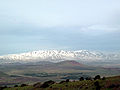 Mount Hermon viewed from Mount Bental in the Golan
 -
 Birkat Ram


See also
- Golan
- Golan Regional Council
- International law and the Arab-Israeli conflict
- UN Security Council Resolution 242
- UN Security Council Resolution 452
- UN Security Council Resolution 465
- UN Security Council Resolution 471
- UN Security Council Resolution 497
- Six-Day War
- Yom Kippur War
- Shebaa Farms
External links
- GAULONITIS in the Jewish Encyclopedia
- GOLAN; GAULONITIS in The International Standard Bible Encyclopedia
- Syrian view of the Golan Heights
- Israeli view of the Golan Heights
- Qatzrin web-site
- The Line of June 4, 1967 and how it came to be
- Golan Heights from palestinefacts.org
- Excerpts from the Moshe Dayan Memoirs
- Golan Heights Examination
- A View From Damascus: Internal Refugees From Golan’s 244 Destroyed Syrian Villages from Washington Report
- Golan Heights Town Tells Tale of Israeli-Arab War from Damascus online
- Planetware travel guide
- Golan Heights Winery
References
- ^ Operation "Syrian Freedom"
- ^ Introduction to Lebanon on GlobalSecurity.org
- ^ Myth & Facts - Boundaries
- ^ Myth & Facts - Boundaries
- ^ Morris (2001) , p. 327: "Another eighty to ninety thousand civilians fled or were driven from the Golan Heights."
- Bregman, Ahron (2002). Israel's Wars: A History Since 1947. London: Routledge. ISBN 0-415-28716-2
- Leon Sheleff (1994). "Application of Israeli law to the Golan Heights is not annexation". Brooklyn journal of international law. 20, afl. 2: 333–353.
- Asher Maoz (1994). "Application of Israeli law to the Golan Heights is annexation". Brooklyn journal of international law. 20, afl. 2: 355–396.
- Tayseer Maar'i & Usama Halabi (1992). "Life under occupation in the Golan Heights". Journal of Palestine Studies. 22: 78–93.
- Morris, Benny (2001) Righteous Victims New York, Vintage Books. ISBN 0-679-74475-4