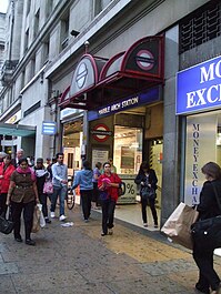
Marble Arch tube station
| Marble Arch | |
|---|---|
 | |
| Location | Oxford Street |
| Local authority | Westminster |
| Managed by | London Underground |
| Number of platforms | 2 |
| Fare zone | 1 |
| London Underground annual entry and exit | |
| 2019 | |
| 2020 | |
| 2021 | |
| 2022 | |
| 2023 | |
| Key dates | |
| 1900 | Opened |
| Other information | |
| External links | |
| Coordinates | 51°30′49″N 0°9′30″W / 51.51361°N 0.15833°W |
Marble Arch is a London Underground station in the City of Westminster. The station is between Lancaster Gate and Bond Street stations on the Central line, and is in Travelcard Zone 1.
History
The station was opened on 30 July 1900 by the Central London Railway (CLR).
Like all the original stations on the CLR, Marble Arch was served by lifts to the platforms but the station was reconstructed in the early 1930s to accommodate escalators. This saw the closure of the original station building, designed by the architect Harry Bell Measures, that was situated on the corner of Quebec Street and Oxford Street, and a replacement sub-surface ticket hall opened further to the west. The new arrangements came into use on 15 August 1932. The original surface building was later demolished.
The platforms, originally lined in plain white tiles, were refitted with decorative vitreous enamel panels in 1985. The panel graphics were designed by Annabel Grey.[6]
The station was modernised (2010) resulting in new finishes in all areas of the station, apart from the retention of various of the decorative enamel panels at platform level.
The station today
The station is named after the Marble Arch nearby and is located at the north east side of the Marble Arch junction, at the western end of Oxford Street.
There is a siding to the west of the station allowing trains from Epping, Hainault and Woodford to terminate here. It isn't commonly used but it is still retained for emergencies and when engineering works take place.
Connections
London Buses routes 2, 13, 16, 30, 36, 74, 94, 98, 137, 148, 159, 189, 274, 390, 414 and 436 serve the station.
See also
- The Mysterious Planet, a serial of Doctor Who which uses Marble Arch as a plot point.
- "London Homesick Blues," a 1974 song by Gary P. Nunn references Marble Arch Station.[7]
Gallery
-
Westbound platform
-
Eastbound platform
-
Decoration on eastbound platform
-
Roundel on platform
References
- ^ "Station Usage Data" (XLSX). Usage Statistics for London Stations, 2019. Transport for London. 23 September 2020. Archived from the original on 9 November 2020. Retrieved 9 November 2020.
- ^ "Station Usage Data" (XLSX). Usage Statistics for London Stations, 2020. Transport for London. 16 April 2021. Retrieved 1 January 2022.
- ^ "Station Usage Data" (XLSX). Usage Statistics for London Stations, 2021. Transport for London. 12 July 2022. Retrieved 7 September 2022.
- ^ "Station Usage Data" (XLSX). Usage Statistics for London Stations, 2022. Transport for London. 4 October 2023. Retrieved 10 October 2023.
- ^ "Station Usage Data" (XLSX). Usage Statistics for London Stations, 2023. Transport for London. 8 August 2024. Retrieved 16 September 2024.
- ^ Underground Architecture; David Lawrence; Capital Transport;1994
- ^ Gary P Nunn Lost Gonzo Band London Homesick Blues – YouTube
External links
- Use dmy dates from August 2012
- Rail transport stations in London fare zone 1
- Central line stations
- London Underground Night Tube stations
- Tube stations in the City of Westminster
- Former Central London Railway stations
- Railway stations opened in 1900
- Railway stations with vitreous enamel panels
- Buildings and structures in Mayfair
- Railway stations located underground in the United Kingdom


