
Kailua, Hawaii
Kailua | |
|---|---|
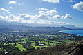
 Aerial photo of Kailua, Enchanted Lake and Mokapu Peninsula | |
 Location in Honolulu County and the state of Hawaii | |
 Kailua Location in Hawaii | |
| Coordinates: 21°23′51″N 157°44′22″W / 21.39750°N 157.73944°W | |
| Country | |
| State | |
| County | |
| Area | |
| • Total | 10.6 sq mi (27.4 km2) |
| • Land | 7.8 sq mi (20.1 km2) |
| • Water | 2.8 sq mi (7.3 km2) |
| Elevation | 16 ft (5 m) |
| Population (2010) | |
| • Total | 38,635 |
| • Density | 3,700/sq mi (1,400/km2) |
| Time zone | UTC−10 (Hawaii–Aleutian) |
| Zip Code | 96734 |
| Area code | 808 |
| FIPS code | 15-23150 |
| GNIS feature ID | 359894 |
Kailua /kaɪˈluːə/ is a census-designated place (CDP) in Honolulu County, Hawaii, United States. It lies in the Koʻolaupoko District of the island of Oʻahu on the windward coast at Kailua Bay. It is in the judicial district and the ahupua'a named Ko'olaupoko. It is 12 miles (19 km) northeast of Honolulu – over Nu‘uanu Pali. The population was 38,635 at the 2010 census.[1]
In the Hawaiian language Kailua means "two seas" or "two currents", a contraction of the words kai (meaning "sea" or "sea water") and ʻelua (meaning "two"); it is so named because of the two lagoons in the district or the two currents which run through Kailua Bay.
Kailua is primarily a residential community, with a centralized commercial district along Kailua Road. The population was 50,000 in 1992.[2] As of the 2017 census,[update] the population has dropped to 38,000.[3]
Places of note in Kailua include Kailua Beach Park, Lanikai Beach, Kawai Nui Marsh, Maunawili Falls,[4] and Marine Corps Base Hawaii. It was home to Barack Obama’s winter White House.
History
Early history
During the reign of King Kākuhihewa and his successors, Kanekapu, Kahoowaha, Kauakahiakahoowaha, and Kualiʻi, Kailua replaced Waikiki as the residential seat of the Oʻahu Rulers (aliʻi nui of Oʻahu). Many ancient temple ruins, such as those at Ulupo Heiau State Historic Site, are in the area.[5]
Beach
Kailua Beach is crescent-shaped, about 2.5 miles (4.0 km) long, and ranging between 50 and 150 feet (15 and 46 m) wide. The ocean bottom fronting the beach slopes gently and beautifully to overhead depths without any coral heads. Light to medium waves support surfing and bodysurfing. The steady trade winds make Kailua Beach a top windsurfing and kitesurfing destination. Robby Naish, first World Champion of windsurfing and Professional Windsurfers Association Hall of Fame inductee, grew up in Kailua.[6][7][8]
Sea kayaking and stand-up paddleboarding to the protected seabird sanctuaries Flat Island and the Nā Mokulua, popularly known as "the Mokes", have become increasingly popular water activities at the beach.
Geography

Kailua is located at 21°23′51″N 157°44′22″W / 21.39750°N 157.73944°W (21.397370, −157.739515).[9] Nearby towns include Kāneʻohe, Maunawili, and Waimānalo.
According to the United States Census Bureau, the CDP has a total area of 10.6 square miles (27.4 km2). 7.8 square miles (20.1 km2) of it is land, and 2.8 square miles (7.3 km2) of it (26.62%) is water.[10] A significant portion of this water area is Kawai Nui Marsh, the largest wetland in the Hawaiian Islands and a nominated Ramsar Convention site.
Kaʻōhao/Lanikai

Kaʻōhao (pronounced [kəʔˈoːhao]) is the earliest known Hawaiian name for the place known as "Lanikai." Kaʻōhao means "the tying" and is derived from an old story in which "two women were tied together here with a loincloth after being beaten in a kōnane game".[11] Kaʻōhao was commercially developed in the 1920s and renamed "Lanikai."[12] It is now an unincorporated community in Kailua on the windward coast at Kailua Bay. Lanikai Beach was rated as one of the top ten beaches in the world by Sherman's Travel Magazine.[13] The area is known for its white powder-like sandy beach, easy access to Nā Mokulua, and its hiking trail along the Keolu Ridge to the World War II military bunkers commonly known as the "Lanikai Pillboxes".[14] Because of its small community and easy access to its famous beach, Lanikai has one of the most expensive real estate markets in Hawaii.[15] It is served by Kailua's zip code, 96734.
Demographics

As of the census of 2000,[16] there were 36,513 people, 12,229 households, and 9,318 families residing in the CDP. The population density was 5,495.8 people per square mile (2,123.2/km2). There were 12,780 housing units, at an average density of 1,923.6 per square mile (743.1/km2). The racial makeup of the CDP was 43.84% White, 0.76% Black or African American, 0.30% Native American, 21.11% Asian, 8.07% Pacific Islander, 0.93% from other races, and 24.99% from two or more races. Hispanic or Latino of any race were 6.10% of the population.
There were 12,229 households, out of which 32.1% had children under the age of 18 living with them, 59.2% were married couples living together, 12.2% had a female householder with no husband present, and 23.8% were non-families. 16.6% of all households were made up of individuals, and 6.0% had someone living alone who was 65 years of age or older. The average household size was 2.98, and the average family size was 3.33.
In the CDP the population was spread out, with 24.1% under the age of 18, 7.2% from 18 to 24, 28.6% from 25 to 44, 26.3% from 45 to 64, and 13.7% who were 65 years of age or older. The median age was 39 years. For every 100 females there were 97.9 males. For every 100 females age 18 and over, there were 95.4 males.
The median income for a household in the CDP was $72,784, and the median income for a family was $79,118. Males had a median income of $46,789, versus $35,612 for females. The per capita income for the CDP was $29,299. About 3.3% of families and 5.4% of the population were below the poverty line, including 5.3% of those under the age of 18 and 1.5% of those 65 and older.
Government and infrastructure
The Honolulu Police Department operates the Kailua Substation in Kailua.[17] The United States Postal Service operates the Kailua Post Office.[18]
The Hawaii Department of Public Safety operates the Women's Community Correctional Center;[19] it was defined in the Maunawili CDP as of the 2000 U.S. Census,[20] but was redefined as being in the Kailua CDP as of the 2010 U.S. Census.[21] NBC News stated that the prison was in Kailua.[22]
The Hawaii Department of Human Services operates the Hawaii Youth Correctional Facility (HYCF),[23] which was defined as Maunawili by the Census Bureau in 2000,[20] and as Kailua by the same organization in 2010.[21] The United States Department of Justice also stated the facility was in Kailua.[24]
Winter White House
Barack Obama has taken winter vacations in 2008 & 2009 in Kailua and in the rented, ocean-front house Plantation Estate in the Paradise Point Estates in 2010, 2011 & 2012. The house was built by developer Harold Kainalu Long Castle, who also lived there.[25] Obama also took a vacation break in August 2008 at a different Kailua house, Oahu Lani, during the 2008 United States presidential election.
 |
 |
Controversy
The arrival of Obama as well as various social media and travel sites have contributed to Kailua becoming overrun by tourists looking to get out of Waikiki.[26]
Education
Public schools
The Hawai'i Department of Education operates the public schools.[21]
Elementary schools in the CDP include Aikahi,[27] Enchanted Lake,[28] Kaʻelepulu,[29] Kailua,[30] Kainalu,[31] Keolu,[32] and Maunawili.[33] Kailua Intermediate School,[34] Kalaheo High School,[35] and Kailua High School are also in the CDP.[36] Kailua High and Maunawili Elementary were defined as being in the Maunawili CDP as of the 2000 Census,[20] but in Kailua CDP as of the 2010 Census.[21]
Kaʻōhao Public Charter School was previously known as Lanikai Elementary Public Charter School and opened in 1964.[37] It became a charter school in 1996,[38] and it received its current name in 2017.[37]
Mokapu Elementary School is on the nearby Marine Corps Base Hawaii (MCBH), outside of the CDP but with a Kailua address.[39]
Area private schools
Catholic schools of the Roman Catholic Diocese of Honolulu:
Others:
- Trinity Christian School
- Redemption Academy
- Windward Adventist School
- Le Jardin Academy (Kailua address but not in the CDP)[42]
- Huakailani School for Girls (K-8) (Kaneohe CDP)[43]
Films
Movies and TV shows that have been filmed in Kailua include:
- Hawaii Five-O (1968): "King of the Hill" – TV episode
- Waikiki (1980) (TV)
- Mädchengeschichten (1998): Shea – "Surfer girl" – TV episode
- Lost (2004–10) – TV episodes
- Magnum, P.I. (1980–88) – TV episodes
- Hawaii Five-0 (2010)- TV episodes
Community
Kailua hosts various events throughout the year, from block parties to fireworks.[44]
Notable people

- Mike Akiu, American football player
- Wally Amos, founder of the "Famous Amos" cookie brand
- Alpha L. Bowser, Lieutenant General, U.S. Marine Corps, decorated for actions during the battles of Iwo Jima and Chosin Reservoir
- Lynne Boyer, former World Champion professional surfer
- Pete Cabrinha (windsurfing, kitesurfing, surfing), professional windsurfer, Peahi tow-in pioneer
- Emily Chang, Bloomberg news anchor
- Henry Ian Cusick, Peruvian-British actor
- Kaʻimi Fairbairn, professional football player
- Scott Feldman, Major League Baseball pitcher
- Sid Fernandez, former Major League Baseball pitcher
- Russ Francis, former professional football player
- Derek Ho (surfing), former World Champion professional surfer, Kailua High Alumni
- Michael Ho, professional surfer, Kailua High Alumni
- David Hughes, former professional American football player
- Kila Ka'aihue, Major League Baseball player
- Les Keiter, Sportscaster
- Allan J. Kellogg, Medal of Honor recipient
- Buzzy Kerbox, professional surfer, windsurfer, Ralph Lauren model
- Evangeline Lilly, Canadian actress
- Denise Michele, model
- Chris Naeole, professional football player
- Robby Naish (windsurfing, kitesurfing), former World Champion professional windsurfer
- B.J. Penn, former Ultimate Fighting Championship welterweight and lightweight champion and world Brazilian jiu-jitsu Champion
- Jonah Ray, comedian and actor
- Samson Satele, professional football player
- Jesse Smith, water polo player
Gallery
-
 View across Kailua Beach to the offshore islet known as Moku nui, one of Nā Mokulua off Lanikai
 -
 View of Kailua from the Kaiwa Ridge Trail (Keolu Hills)
 -
 View of Kailua Town from Ahiki, the third peak of Olomana


References
- ^ "Profile of General Population and Housing Characteristics: 2010 Demographic Profile Data (DP-1): Kailua CDP (Honolulu County), Hawaii". United States Census Bureau. Retrieved May 18, 2012.
- ^ "History of Kailua". Kailua, HI, USA: Kailua Chamber of Commerce. Retrieved October 18, 2012.
- ^ "Kailua, HI | Data USA". datausa.io. Retrieved December 11, 2019.
- ^ "Na Ala Hele - Hawaii Trail System: Oahu: 14". Hawaiitrails.ehawaii.gov. September 21, 2000. Retrieved July 29, 2014.
- ^ "Ulupo Heiau State Historic Site". Department of Land and Natural Resources. State of Hawaii. Archived from the original on May 4, 2012. Retrieved December 21, 2008.
{{cite web}}: CS1 maint: unfit URL (link) - ^ "Kailua, Oahu". aloha-hawaii.com. Media-HI, Inc. Archived from the original on April 2, 2010. Retrieved December 21, 2008.
- ^ World of Windsurfing : Robby Naish
- ^ PWA Profile – Naish
- ^ "US Gazetteer files: 2010, 2000, and 1990". United States Census Bureau. February 12, 2011. Retrieved April 23, 2011.
- ^ "Geographic Identifiers: 2010 Demographic Profile Data (G001): Kailua CDP (Honolulu County), Hawaii". United States Census Bureau. Retrieved May 18, 2012.
- ^ "Hawaiian Place Names". Ulukau.org. Retrieved July 29, 2014.
- ^ "History". Lanikai Association. Retrieved July 29, 2014.
- ^ "Top 10 beaches we love". msnbc.com. Microsoft. February 28, 2006. Archived from the original on December 8, 2005. Retrieved December 21, 2008.
- ^ "A Windward Hike To Remember | Keeping Score | Midweek.com". Archived from the original on August 29, 2011. Retrieved July 11, 2011.
- ^ "Lanikai Real Estate". Archived from the original on October 21, 2011. Retrieved July 11, 2011.
- ^ "U.S. Census website". United States Census Bureau. Retrieved January 31, 2008.
- ^ "Contacting HPD Archived May 31, 2010, at the Wayback Machine." Honolulu Police Department. Retrieved on May 19, 2010. "219 Kuulei Road Kailua, HI 96744"
- ^ "Post Office Location – KAILUA Archived July 3, 2010, at the Wayback Machine." United States Postal Service. Retrieved on August 22, 2010. "335 HAHANI ST KAILUA, HI "
- ^ "Women's Community Correctional Center." Hawaii Department of Public Safety. Retrieved on May 19, 2010.
- ^ a b c 2000 Map: "CENSUS 2000 BLOCK MAP: MAUNAWILI CDP" (PDF). U.S. Census Bureau. Retrieved October 8, 2020.
2010 Map: "2010 CENSUS - CENSUS BLOCK MAP: Maunawili CDP, HI" (PDF). U.S. Census Bureau. Retrieved October 8, 2020. - Maunawili Elementary, Kailua High, and the prisons were in the CDP in 2000, but in 2010 were no longer in the CDP. - ^ a b c d "2010 CENSUS - CENSUS BLOCK MAP: Kailua CDP, HI" (PDF). U.S. Census Bureau. Retrieved October 8, 2020.
2000 boundaries: "CENSUS 2000 BLOCK MAP: KAILUA CDP" (PDF). U.S. Census Bureau. Retrieved October 8, 2020. - Pages 1 and 2 - ^ "LexisNexis sells its database to prisons." Associated Press at NBC News. March 16, 2004. Retrieved on May 19, 2010. "Harry Fuchigami, librarian at the Women's Community Correctional Center in Kailua."
- ^ "Frequently Called Numbers." Hawaii Department of Public Safety. Retrieved on August 22, 2010. "Hawaii Youth Correctional Facility" "42–477 Kalanianaole Highway Kailua, HI 96734"
- ^ "Re: Investigation of the Hawaii Youth Correctional Facility, Kailua, Hawaii Archived May 30, 2010, at the Wayback Machine." United States Department of Justice. Retrieved on August 22, 2010.
- ^ President Returns to Paradise Point Estates, the Obama Winter White House – KAILUA, Hawaii, Dec. 23, 2010
- ^ "Is This Charming Town Hawaii's Next Waikiki?". Huffington Post. March 28, 2015.
- ^ "Contact". Aikahi Elementary School. Retrieved October 8, 2020.
281 Ilihau Street Kailua, HI 96734
- ^ "Home". Enchanted Lake Elementary School. Retrieved October 8, 2020.
770 Keolu Drive, Kailua, HI 96734
- ^ "Home". Ka'elepulu Elementary School. Retrieved October 8, 2020.
530 Keolu Dr. , Kailua ,HI 96734
- ^ "Kailua Elementary". Hawaii Department of Education. Retrieved October 8, 2020.
315 Kuulei Road Kailua, Hawaii 96734
- ^ "Home". Kainalu Elementary School. Retrieved October 8, 2020.
165 Kaiholu Street Kailua, HI 96734
- ^ "Home". Keolu Elementary School. Retrieved October 8, 2020.
416 Keolu Dr. Kailua, HI 96734
- ^ "Home". Maunawili Elementary School. Retrieved October 8, 2020.
1465 Ulupi'i Street, Kailua, HI 96734
- ^ "Home". Kailua Intermediate School. Retrieved October 8, 2020.
145 South Kainalu Drive, Kailua, Hawaii 96734
- ^ "Home". Kalaheo High School. Retrieved October 8, 2020.
730 Iliaina Street Kailua, HI 96734
- ^ "Home". Kailua High School. Retrieved October 8, 2020.
451 Ulumanu Drive Kailua, HI 96734
- ^ a b Hiraishi, Kuʻuwehi. "Kaʻōhao School Name Change Revives History, But Can it Spark a Movement?". Hawaii Public Radio. Retrieved October 8, 2020.
- ^ Adelman, Nancy; Finnigan, Kara. ""We're Here to Complete, Not Complete": A Report from a Demonstration Project to Connect Charter Schools and Other Public Schools". SRI International/National Education Association. p. 4/28. Retrieved October 8, 2020.
- ^ "Home". Mokapu Elementary School. Retrieved October 8, 2020.
Mokapu Elementary [...] is the only school aboard Marine Corps Base Hawaii.[...]1193 Mokapu Rd. Kailua, HI 96734
- The address shows it is outside of the CDP. - ^ "Home". St. Anthony School. Retrieved October 8, 2020.
148 Makawao Street Kailua, Hawaii 96734
- ^ "Home". St. John Vianney School. Retrieved October 8, 2020.
940 Keolu Drive Kailua, HI 96734
- ^ "Home". Le Jardin Academy. Retrieved October 8, 2020.
917 Kalanianaole Highway Kailua, HI 96734
- A comparison shows it is not in the CDP. - ^ "Home". Huakailani School for Girls. Retrieved January 8, 2020.
45-035 Kaneohe Bay Drive, Kaneohe, Hi 96744 (YWCA Kokokahi)
- ^ "Kailua Events". Kailua, HI, USA: Kailua Chamber of Commerce. Retrieved October 18, 2012.
External links
 Kailua travel guide from Wikivoyage
- Kailua Chamber of Commerce
- Kailua Business Directory
Islands, municipalities, and communities of Honolulu County, Hawaii, United States | |||||
|---|---|---|---|---|---|
| CDPs |
|  | |||
| Other communities | |||||
| Government |
| ||||
| International | |
|---|---|
| National | |
| Geographic | |