
Provincetown, Massachusetts: Difference between revisions
PoeticVerse (talk | contribs) m Reverted edits by 98.217.247.96 (talk) to last revision by 67.71.127.150 (HG) |
|||
| Line 185: | Line 185: | ||
*[[Alice Brock]], subject of [[Arlo Guthrie]]'s 1966 song "Alice's Restaurant," owns an art gallery in town |
*[[Alice Brock]], subject of [[Arlo Guthrie]]'s 1966 song "Alice's Restaurant," owns an art gallery in town |
||
*[[Marc Jacobs]], fashion designer |
*[[Marc Jacobs]], fashion designer |
||
*[[Tyler Maren]], sassy young man |
|||
==Gallery== |
==Gallery== |
||
Revision as of 20:48, 25 June 2010
The United States Census Bureau provides additional demographic detail for the more densely populated central village area within the town. Those details are included in the aggregate population and area values reported here. See: Provincetown (CDP), Massachusetts.
Provincetown, Massachusetts | |
|---|---|
 Provincetown center, as viewed from the Pilgrim Monument. | |
| Nickname: "P-town" | |
 Location in Barnstable County in Massachusetts | |
 U.S. Census Map | |
| Country | United States |
| State | Massachusetts |
| County | Barnstable |
| Settled | 1700 |
| Incorporated | 1727 |
| Government | |
| • Type | Open town meeting |
| • Town Manager | Sharon Lynn |
| Area | |
| • Total | 17.5 sq mi (45.2 km2) |
| • Land | 9.7 sq mi (25.0 km2) |
| • Water | 7.8 sq mi (20.2 km2) |
| Elevation | 40 ft (12 m) |
| Population (2007[1]) | |
| • Total | 3,171 |
| • Density | 355.2/sq mi (137.1/km2) |
| Time zone | UTC-5 (Eastern) |
| • Summer (DST) | UTC-4 (Eastern) |
| ZIP code | 02657 |
| Area code | 508 / 774 |
| FIPS code | 25-55500 |
| GNIS feature ID | 0618258 |
| Website | http://www.provincetown-ma.gov/ |

Provincetown is a town located at the extreme tip of Cape Cod in Barnstable County, Massachusetts, United States. The population was 3,431 at the 2000 census, with an estimated 2007 population of 3,174.[2] Sometimes called "P-town",[3][4] the town is known for its beaches, harbor, artists, tourist industry, and its reputation as a gay village.
History


The area was originally settled by the Nauset tribe, who had a settlement known as Meeshawn. Provincetown was incorporated by English settlers in 1727 after harboring ships for more than a century. Bartholomew Gosnold named Cape Cod in Provincetown Harbor in 1602.[5] In 1620, the Pilgrims signed the Mayflower Compact when they arrived at the harbor. They agreed to settle and build a self-governing community, and then came ashore in the West End.[6] Though the Pilgrims chose to settle across the bay in Plymouth, Provincetown enjoyed an early reputation for its fishing grounds. The "Province Lands" were first formally recognized by the union of Plymouth colony and Massachusetts Bay colony in 1692, and its first municipal government was established in 1714.[7] The population of Provincetown remained small through most of the 18th century.
Following the American Revolution, however, Provincetown grew rapidly as a fishing and whaling center.[7] The population was bolstered by a number of Portuguese sailors who, hired to work on US ships, came to live in Provincetown. By the 1890s, Provincetown was booming, and began to develop a resident population of writers and artists, as well as a summer tourist industry. After the 1898 Portland Gale severely damaged the town's fishing industry, members of the town's art community took over many of the abandoned buildings. By the early decades of the 20th century, the town had acquired an international reputation for its artistic and literary output. The Provincetown Players was an important experimental theater company formed during this period. It was an example of intellectual and artistic connections to Greenwich Village in New York that began then.
The town includes eight buildings and a historic district on the National Register of Historic Places.
In the mid-1960s, Provincetown saw population growth. The town's rural character appealed to the hippies of the era; furthermore, property was relatively cheap and rents were correspondingly low, especially during the winter. Many of those who came stayed and raised families. Commercial Street gained numerous cafes, leather shops, head shops — various hip small businesses blossomed and many flourished.
In the mid-1970s members of the gay community began moving to Provincetown. In 1978 the Provincetown Business Guild (PBG) was formed to promote gay tourism. Today more than 200 businesses belong to the PBG and Provincetown is perhaps the best-known gay summer resort on the East Coast.
Since the 1990s, property prices have risen significantly, with numerous condo conversions causing some residents economic hardship. The recent housing bust (starting in 2005) has so far caused property values in and around town to fall by 10 percent or more in less than a year.[8] This has not slowed down the town's economy, however. Provincetown's tourist season has expanded to the point where the town has created festivals and weeklong events throughout the year. The most established are in the summer: the Portuguese Festival and PBG's Carnival Week.
Geography

Provincetown is located at the tip of Cape Cod. The town's total area is 17.5 square miles (45 km2), 9.7 square miles (25 km2) of it being land and 7.8 square miles (20 km2) of it water. The town is bordered by the town of Truro to the east, Provincetown Harbor to the southeast, Cape Cod Bay to the south and west, and Massachusetts Bay to the north. The town is 45 miles (72 km) north (by road) from Barnstable, 62 miles (100 km) by road to the Sagamore Bridge, and 115 miles (185 km) from Boston via roadway.
Nearly two-thirds of the town's land area is covered by the Cape Cod National Seashore. To the north lie the "Province Lands," the area of dunes and small ponds extending from Mount Ararat in the east to Race Point in the west, along the Massachusetts Bay shore. The Cape Cod Bay shoreline extends from Race Point to the far west to the Wood End in the south, eastward to Long Point, which points inward towards the Cape, and providing a natural barrier for Provincetown Harbor. All three points are marked by lighthouses. The town's population center extends along the harbor, south of the Seashore's lands.
Transportation

Provincetown is the eastern terminus of U.S. Route 6, both in the state and in the nation. Although the terminus is directed east officially, geographically speaking, the road, having curved around Cape Cod, is facing west-southwest at the point, and is marked only by its junction with Route 6A. The state-controlled portion ends with a "STATE HIGHWAY ENDS" sign as the road enters the Cape Cod National Seashore, after which the road is under federal maintenance. Route 6A passes through the town as well, mostly following Bradford Street (whereas US 6 originally followed Commercial Street before the bypass was built and Commercial Street was switched to one-way westbound), and ending just south of the Herring Cove Beach.
Provincetown is served by seasonal ferries to Boston and to Plymouth that charge their passengers up to $49 for a one-way trip, up to $79 for a round-trip ticket.[9][10] Both dock at MacMillan Pier, located just east of the Town Hall. The town has no rail service (the town's only railway having been abandoned by the New York, New Haven and Hartford Railroad in the early 1960s), but is the home of Provincetown Municipal Airport, located just east of Race Point.
The Cape Cod Regional Transit Authority offers flex route buses between MacMillan Pier and Harwich and a shuttle to Truro. Provincetown is also served by Mercedes Cab & Livery taxis and Ptown Pedicabs.
The airport is mostly for General Aviation, but does receive regular scheduled service from Cape Air which also operates code-share flights for JetBlue. It is a well-equipped if small general-aviation airport with a single 3,500-foot (1,100 m) runway, an ILS approach, and full lighting. The nearest national and international service is from Logan International Airport in Boston.
Demographics

United States census information
According to the U.S. census of 2000,Template:GR there were 3,431 people, 1,837 households, and 464 families residing in the town. The population density was 355.2 inhabitants per square mile (137.1/km2). There were 3,890 housing units at an average density of 402.7 per square mile (155.5/km2). The racial makeup of the town was 87.55% White, 7.52% African American, 0.32% Native American, 0.50% Asian, 1.08% from other races, and 3.03% from two or more races. Hispanic or Latino of any race were 2.16% of the population. The top reported ancestries were Portuguese (22.6%), Irish (13.9%), English (10.4%), and Italian (8.7%).
There were 1,837 households out of which 9.0% had children under the age of 18 living with them, 17.7% were married couples living together, 5.3% had a female householder with no husband present, and 74.7% were non-families. 53.2% of all households were made up of individuals and 14.5% had someone living alone who was 65 years of age or older. The average household size was 1.69 and the average family size was 2.65.
In the town the population was spread out with 8.0% under the age of 18, 5.2% from 18 to 24, 36.1% from 25 to 44, 32.9% from 45 to 64, and 17.8% who were 65 years of age or older. The median age was 45 years. For every 100 females there were 115.5 males. For every 100 females age 18 and over, there were 116.2 males.
The median income for a year-round household in the town was $32,716, and the median income for a family was $39,679. Males had a median income of $30,556 versus $25,298 for females. The per capita income for the town was $26,109. About 8.5% of families and 16.3% of the population were below the poverty line, including 22.7% of those under age 18 and 17.0% of those age 65 or over.
Provincetown's zip code has the highest concentration of same-sex couple households of any zip code in the United States.[11]
Demographics in a resort town
Traditional sources such as the United States Census, municipal voting rolls and property records may not accurately portray the demography of resort towns. While Provincetown's year-round population is small and has been declining, the summer population has been estimated at 60,000.
And economic statistics based on federal census figures may be deceptive. For example, the census counts 3,890 housing units in Provincetown, but only 1,837 "households." And there is an apparent disparity between the census figures for median household income ($32,716) and median home value ($323,600).
Part-time residents are not counted in the census. These people may own a second home in the town or pay rent for up to six months each year. Many of them pay property and other taxes, hold jobs in the community and even own businesses.
Government

Provincetown is represented in the Massachusetts House of Representatives as a part of the Fourth Barnstable district, which includes (with the exception of Brewster) all the towns east and north of Harwich on the Cape. The seat is held by Democrat Sarah Peake, a former Provincetown selectman. The town is represented in the Massachusetts Senate as a part of the Cape and Islands District, which includes all of Cape Cod, Martha's Vineyard and Nantucket except the towns of Bourne, Falmouth, Sandwich and a portion of Barnstable.[12] The Senate seat is held by Democrat Robert A. O'Leary. Provincetown is patrolled by the Second (Yarmouth) Barracks of Troop D of the Massachusetts State Police.[13]
On the national level, Provincetown is a part of Massachusetts's 10th congressional district, and is currently represented by Bill Delahunt. Following the death of Ted Kennedy, the state's senior (Class I) member of the United States Senate is John Kerry (re-elected in 2008); the junior (Class II) senate seat is held by Scott Brown, the victor in the special Senate election on January 19, 2010.
Provincetown is governed by the open town meeting form of government, and is led by a town manager and a board of selectmen. The town has its own police and fire departments, both of which are stationed on Shankpainter Road. The town's post office is located along Commercial Street, near the town's Fourth Wharf. The town's Provincetown Public Library is also located along Commercial Street, in the former Center Methodist Episcopal Church building since 2005.
Education
Provincetown operates its own schools for the approximately 200 school-aged children in town. The Veterans Memorial Elementary School serves students from pre-kindergarten through sixth grades, and the Provincetown High School serves students from seventh through twelfth grades (and also accepts students from Truro). PHS's sports teams are known as the Fishermen, and the school colors are black and orange. There are no private schools in Provincetown; students may attend Cape Cod Regional Technical High School in Harwich or Nauset Regional High School in North Eastham free of charge.
In June 2010, the Provincetown School Board generated controversy when it was revealed that Provincetown elementary schools are making condoms available to Children as young as five years old without informing parents.[14]
Culture
In 2003, Provincetown received a $1.95 million low interest loan from the Rural Development program of the U.S. Department of Agriculture (USDA) to help rebuild the town's MacMillan Pier. It primarily serves tourists and high-speed ferries that charge their passengers up to $45 per one-way trip. Between 2004 and 2007, the Provincetown Art Association and Museum[15] received four Rural Development grants and loans totalling $3 million to increase the museum's space, add climate-controlled facilities, renovate a historic sea captain's house (the Hargood House) and cover cost overruns.[16] As the mission of the Rural Development program is "To increase economic opportunity and improve the quality of life for all rural Americans",[17] the USDA considered Provincetown's residents in the 2000s to still be rural and to still require such federal assistance.
The Atlantic House in Provincetown is a contender for the oldest gay bar in the United States and Frommer's calls it "the nation's premier gay bar".[18][19][20]
Other notable festivals during the year include the Christmas-themed "Holly Folly", "Bear Week", "Mate's Leather Weekend", "Women's Week", "Family Week", "Single Men's Weekend", "Provincetown International Film Festival", "Provincetown Rocks: The Festival!" and the "Provincetown Jazz Festival." In October, Provincetown sees the arrival of transvestite, transgender and transsexual people for the annual Fantasia Fair. Started in 1975, it is the longest running event of its kind in the USA.
The Gold Dust Orphans have been performing in Provincetown and Boston for 14 years. Notable summer productions have included: The Gulls, Scarrie, The Stepford Wives, Golden Squirrels, Cinderella Rocks!, Cleopatra, The Milkman Always Comes Twice, Wizzin' and "Willy Wanker and the Hershey Highway". Current and past company members include Penny Champayne, Olive Another, Afrodite aka Andre Shoals, Windsor Newton, Amber Dawn (a.k.a. Oosha Boom), P.J. McWhiskers, David Hanbury, Adam Berry, Deborah Downer, Megan Ludlow, Ariana Schulman, Mark Meehan, Gene Dante, Billy Hough, Larry Coen, Cheryl Singleton and many others.
Norman Mailer's novel Tough Guys Don't Dance, and Annie Dillard's novel The Maytrees are primarily based in Provincetown.
Provincetown was mentioned, along with various other Cape Cod locations, in the Vampire Weekend song 'Walcott', which featured on their 2008 debut album Vampire Weekend.
Notable residents
- Playwrights Tennessee Williams, Eugene O'Neill, and Susan Glaspell
- Former United States Poet Laureate Stanley Kunitz
- International journalists Mary Heaton Vorse, John Reed, and Louise Bryant
- Visual artists Charles Hawthorne, E. Ambrose Webster, Marsden Hartley, Robert Motherwell, Hans Hofmann, Franz Kline, Willem de Kooning, Jackson Pollock, and Henry Hensche
- Photographers Joel Meyerowitz, Norma Holt, and Charles Fields[citation needed]
- Arctic explorer Donald B. MacMillan
- Norman Mailer, author, winner of the Pulitzer Prize, and co-founder of the Village Voice
- Mary Oliver, poet and winner of the Pulitzer Prize
- John Waters, filmmaker
- Harry Kemp poet of the dunes and author ""Tramping on Life" and "More Miles"
- Michael Cunningham, author of the Pulitzer Prize-winning The Hours
- David Drake, Obie Award-winning playwright, stage director, actor and author.
- Andrew Sullivan, author, columnist for the Atlantic Monthly, and blogger
- Andy Towle, poet and founder of Towleroad.com
- Al Jaffee, cartoonist for MAD Magazine
- Mark Doty, poet and author
- William J. Mann, author and historian
- Kate Clinton, comedian and writer
- Prescott Townsend, early LGBT activist
- Nancy Whorf, artist/painter, daughter of National Academy watercolor artist John Whorf[citation needed]
- Mark Protosevich, screenwriter of The Cell, Poseidon and more recently, the 2007 adaptation of I Am Legend
- Herman Maril, artist
- Howard Mitcham, artist, poet, cook
- Alice Brock, subject of Arlo Guthrie's 1966 song "Alice's Restaurant," owns an art gallery in town
- Marc Jacobs, fashion designer
Gallery
-
The Pilgrim Monument
-
 A bronze mural of the signing of the Mayflower Compact, Bradford Street
 -
 Memorial to the lost Pilgrims of the Mayflower
 -
 A Tall Ship docked in Provincetown Harbor
 -
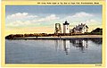 An old postcard depicting Long Point Light
 -
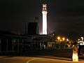 The Pilgrim Monument at night
 -
 Late July Sunset at Race Point Beach
 -
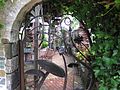 A secluded patio off Commercial Street


References
- ^ "City-Data: Provincetown, MA".
{{cite web}}: Text "Mar. 4, 2010" ignored (help) - ^ "City-Data: Provincetown, MA".
{{cite web}}: Text "Mar. 4, 2010" ignored (help) - ^ "AG sues Cape Timeshare; Sexy Cape moms on Craig's List; Ptown Fed project questioned; Towns call foul over CCBL; State loses wind". Retrieved 2009-04-30.
- ^ Bragg, Mary Ann. "Raw sewage soils P'town police headquarters". Retrieved 2009-04-30.
- ^ Archer, Gabriel (1912). Ed. Frances Healey (ed.). Great Epochs in American History: the Relation of Captain Gosnold's Voyage. Funk & Wagnalls Co. p. 38.
- ^ Rich, Shebnah (1883). Truro-Cape Cod or Land Marks and Sea Marks. Boston: D. Lothrop & Co. p. 53.
- ^ a b Deyo, Simeon L. (1890). History of Barnstable County. New York: H. W. Blake & Co. p. 961.
- ^ David Colman (September 4, 2005). "Rich Gay, Poor Gay". New York Times. Retrieved May 22, 2010.
{{cite journal}}: More than one of|work=and|journal=specified (help) - ^ Boston-Provincetown ferry Retrieved on April 5, 2007
- ^ Plymouth-Provincetown ferry Retrieved on April 5, 2007
- ^ Facts and Findings from The Gay and Lesbian Atlas, Urban Institute, March 30, 2004
- ^ Index of Legislative Representation by City and Town, from Mass.gov
- ^ Station D-2, SP Yarmouth
- ^ [1]
- ^ The Provincetown Art Association and Museum (PAAM) Retrieved on April 5, 2007
- ^ Gaul, Gilbert M. and Cohen, Sarah (April 6, 2007). "Rural Aid Goes to Urban Areas: USDA Development Program Helps Suburbs, Resort Cities". Washington Post. Retrieved May 22, 2010.
{{cite journal}}: More than one of|work=and|journal=specified (help)CS1 maint: multiple names: authors list (link) - ^ USDA Rural Development: mission statement Retrieved on April 5, 2007
- ^ The History of Atlantic House
- ^ Café Lafitte in Exile in New Orleans, Louisiana purports to be the oldest gay bar in the country but an investigation of that establishment's website and a few other sources failed to reveal the dates or specifics upon which that claim is based.
- ^ Frommer's review of The Atlantic House.
External links
- Provincetown.com -- Provincetown's Home on the Web
- Provincetown
- Town of Provincetown official website
- Provincetown Live Online Community
- Provincetown Library Official website
- Provincetown Banner
- Provincetown official tourism website
- Provincetown Chamber of Commerce
- Provincetown Jazz Festival
- Provincetown Music Festival
- Provincetown, MA - Index of Marriages and Deaths
- Provincetown beaches: Sticker fees, photos, map
- Template:Wikitravel
