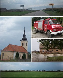
Vera, Croatia
Vera
| |
|---|---|
 | |
 Location of Vera in Croatia | |
| Coordinates: 45°25′N 18°54′E / 45.417°N 18.900°E | |
| Country | |
| Region | Slavonia (Podunavlje) |
| County | |
| Municipality | Trpinja |
| Government | |
| • Body | Local Committee |
| Population (2011)[3] | |
| • Total | 453 |
| Time zone | UTC+1 (CET) |
| • Summer (DST) | UTC+2 (CEST) |
| Postal code | 32 225 |
| Area code | +385 (0)32 |
| Vehicle registration | VU |
| Official languages | Croatian, Serbian[2] |
Vera (Serbian Cyrillic: Вера[4]) is a village in Trpinja Municipality in eastern Croatia. The village is the northernmost settlement of the Vukovar-Syrmia County.
Name
The villages of Trpinja, Bobota and Vera share a common legend about the origin of their names. According to the legend, the ancestors of today's inhabitants of villages, who settled at the time of the Great Serb Migrations under Arsenije III Čarnojević, were called Bobe. They were fleeing from the Ottoman Empire conquests of Balkan as they wanted to preserve their religious freedom.
This legendary religious commitment and orthodoxy was coined in the local phrase Bobe endured for the faith or originally in Serbian Bobe trpiše za veru. The family name of 'Bobe' was used as the basis for the name of Bobota, the word 'endured' (Serbian: trpiti) the name of Trpinja was created and from the word of faith (Serbian: vera) the name of Vera was coined.[5]
Geography
Area of Vera and neighboring Trpinja and Bobota have the lowest elevation among the villages north of the Vuka River within their country.[6]
History
Up until the mid-XIX century area of Vera was a part of much larger Palača Swamplands.[7] After the completion of Bobota Canal surrounding areas were transformed into agricultural lands.[7]
Education
Branch school of the Elementary School Bobota is located in Vera. Education at the local schools is implemented in Serbian language similarly to many other schools in eastern Croatia since the days of peaceful reintegration of the region completed in 1998.[8] The first school in Vera was opened in 1789.
Sports
- NK Hajduk Vera, football club
Gallery
See also
References
- ^ "Statut Općine Trpinja" (PDF). Retrieved 25 May 2015.
- ^ a b Government of Croatia (October 2013). "Peto izvješće Republike Hrvatske o primjeni Europske povelje o regionalnim ili manjinskim jezicima" (PDF) (in Croatian). Council of Europe. p. 36. Retrieved 30 November 2016.
- ^ "Population by Age and Sex, by Settlements, 2011 Census: Vera". Census of Population, Households and Dwellings 2011. Zagreb: Croatian Bureau of Statistics. December 2012.
- ^ "Minority names in Croatia:Registar Geografskih Imena Nacionalnih Manjina Republike Hrvatske" (PDF). Archived from the original (PDF) on October 29, 2013. Retrieved 2013-03-08.
- ^ http://www.trpinja.hr/index.php?option=com_content&view=article&id=13&Itemid=26&lang=hr[permanent dead link]
- ^ Marković, M. (2003). Istočna Slavonija: Stanovništvo i naselja. Naklada Jesenski i Turk. Zagreb.
- ^ a b Branko, Nadilo (2012). "Nova akumulacija u slivu rijeke Vuke: Zaštita od poplava i navodnjavanje" (PDF). Građevinar. 10 (64). Croatian Association of Civil Engineers: 833–844. Retrieved 22 January 2019.
- ^ Popis osnovnih i srednjih škola s nastavom na jeziku i pismu nacionalnih manjina po modelu A, školska godina 2011./2012., Ministarstvo znanosti obrazovanja i sporta


