Chernivtsi, Vinnytsia Oblast
Appearance
Chernivtsi | |
|---|---|
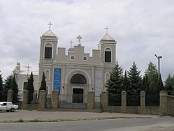
 St. Nicholas' Catholic church | |
| Coordinates: 48°32′33″N 28°06′44″E / 48.5425°N 28.1122°E | |
| Country | |
| Province | |
| District | Chernivtsi Raion |
| First mentioned | 1392 |
| Population (2020) | |
| • Total | 2,622 |
| Time zone | UTC+2 (EET) |
| • Summer (DST) | UTC+3 (EEST) |
Chernivtsi is an urban settlement (town) in Vinnytsia Oblast (province), located in the historic region of Podolia. It is the administrative center of Chernivtsi Raion. Population: 2,622 (2020 est.)[1]
History
Until the Partitions of Poland Czerniejowce (or Czernijowce) was a private town of Poland, located in the Lesser Poland Province of the Polish Crown, owned by the houses of Koniecpolski and Lubomirski.[2]
References
- ^ Чисельність наявного населення України на 1 січня 2020 року / Population of Ukraine Number of Existing as of January 1, 2020 (PDF) (in Ukrainian and English). Kyiv: State Statistics Service of Ukraine. Archived (PDF) from the original on 28 September 2023.
- ^ Geographical Dictionary of the Kingdom of Poland, vol. 1, p. 825
External links
- Chernivtsi[permanent dead link] at the Verkhovna Rada website
- Chernivtsi at the Informational portal "Vinnytsia Oblast as part of the Ukrainian SSR"


