Iridium 33
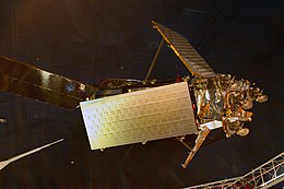
 A mockup of an Iridium satellite | |
| Mission type | Communication |
|---|---|
| Operator | Iridium Satellite LLC |
| COSPAR ID | 1997-051C |
| SATCAT no. | 24946 |
| Mission duration | 11 years |
| Spacecraft properties | |
| Bus | LM-700A |
| Manufacturer | Lockheed Martin |
| Launch mass | 700 kg |
| Start of mission | |
| Launch date | 14 September 1997, 01:36 UTC |
| Rocket | Proton-K / DM2 |
| Launch site | Baikonur, Site 81/23 |
| Contractor | Khrunichev via International Launch Services |
| End of mission | |
| Destroyed | 10 February 2009, 16:56 UTC Collision with Kosmos 2251 |
| Orbital parameters | |
| Reference system | Geocentric |
| Regime | Low Earth |
| Perigee altitude | 779.6 km [1] |
| Apogee altitude | 799.9 km |
| Inclination | 86.4° |
| Period | 100.4 minutes |
| Epoch | 10 February 2009 |
Iridium 33 was a communications satellite launched by Russia for Iridium Communications. It was launched into low Earth orbit from Site 81/23 at the Baikonur Cosmodrome at 01:36 UTC on 14 September 1997, by a Proton-K rocket with a Block DM2 upper stage.[2][3] The launch was arranged by International Launch Services (ILS). It was operated in Plane 3 of the Iridium satellite constellation, with an ascending node of 230.9°.[2]
Mission
Iridium 33 was part of a commercial communications network consisting of a constellation of 66 LEO spacecraft. The system uses L-Band to provide global communications services through portable handsets. Commercial service began in 1998. The system employs ground stations with a master control complex in Landsdowne, Virginia, a backup in Italy, and a third engineering center in Chandler, Arizona.[4]
Spacecraft
The spacecraft was 3-axis stabilized, with a hydrazine propulsion system. It had 2 solar panels with 1-axis articulation. The system employed L-Band using FDMA/TDMA to provide voice at 4.8 kbps and data at 2400 bps with a 16 dB margin. Each satellite had 48 spot beams for Earth coverage and used Ka-Band for crosslinks and ground commanding.[4]
Destruction
On 10 February 2009, at 16:56 UTC, at about 800 km altitude, Kosmos 2251 (1993-036A) (a derelict Strela satellite) and Iridium 33 collided, resulting in the destruction of both spacecraft.[5] NASA reported that a large amount of space debris was produced by the collision, i.e. 1347 debris for Kosmos 2251 and 528 for Iridium 33.[6][7][8][9]
See also
References
- ^ "Iridium 33 tracking details". Retrieved 2019-02-04.
- ^ a b Wade, Mark. "Iridium". Encyclopedia Astronautica. Archived from the original on 2009-02-16. Retrieved 2009-02-12.
- ^ Wade, Mark. "Proton". Encyclopedia Astronautica. Archived from the original on September 13, 2008. Retrieved 2009-02-12.
- ^ a b "Iridium 33: Display 1997". nssdc.gsfc.nasa.gov. NASA. 14 May 2020. Retrieved 5 June 2020.
 This article incorporates text from this source, which is in the public domain.
- ^ Iannotta, Becky (2009-02-11). "U.S. Satellite Destroyed in Space Collision". Space.com. Retrieved 2009-02-11.
- ^ "2 orbiting satellites collide 500 miles up". Associated Press. 2009-02-11. Retrieved 2009-02-11.
- ^ "Google Earth KMZ file of the debris". John Burns. 2009-03-05. Retrieved 2010-11-25.
- ^ "U.S. Space debris environment and operational updates" (PDF). NASA. 2011-02-18. Retrieved 5 June 2020.
 This article incorporates text from this source, which is in the public domain.
- ^ "Javascript visualisation of Iridium 33 debris".
