Shakarparian
Appearance
| Shakarparian | |
|---|---|
| شکر پڑیاں | |
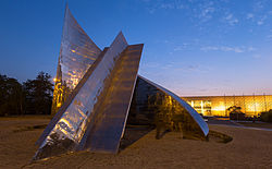
 Star and Crescent Monument near the start of Shakarparian | |
 | |
| Type | Public |
| Location | Islamabad, Pakistan |
Shakarparian (Template:Lang-ur; also known as Shakarparian Hills) is a hill, and a national park located near the Zero Point Interchange in Islamabad, Pakistan.[1] Pakistan Monument and Pakistan Monument Museum are also located in Shakarparian.
The old Gakhar tribe leaders settled here before the Indo-Pak partition in 1947; later the clan was relocated to create a park for newly marked federal capital of the country in 1960–61.[2]
Shakarparian also has a parade ground which hosts the Pakistan Day Parade every year on 23 March.[3]
See also
References
- ^ "Lively Spring Festival kicks off at Shakarparian". thenews.com.pk. February 25, 2013. Retrieved March 4, 2013.
- ^ "Shakarparian, a local park in ISD". etdip.com. Archived from the original on December 25, 2018. Retrieved March 4, 2013.
- ^ "Pakistan shows off military might at annual parade in Islamabad". Dawn. 2021-03-25. Retrieved 2023-03-15.
33°41′N 73°05′E / 33.683°N 73.083°E
