
Wanakawri (Cusco)
| Wanakawri | |
|---|---|
 A view of Cusco and the mountains southeast of it | |
| Highest point | |
| Elevation | 4,089 m (13,415 ft)[1] |
| Coordinates | 13°35′40″S 71°54′20″W / 13.59444°S 71.90556°W |
| Naming | |
| Language of name | Quechua |
| Geography | |
 Wanakawri Peru | |
| Location | Peru, Cusco Region, Cusco Province |
| Parent range | Andes |
Wanakawri (Quechua, also spelled Guanacaure, Guanacauri, Huanacaure, Huanacauri, Wanacaure, Wanacauri, Wanakaure, Wanakauri) is an archaeological site[2] and a legendary mountain in Peru. It is situated in the Cusco Region, Cusco Province, in the districts San Jerónimo and San Sebastián, and in the Paruro Province, Yaurisque District.[3][4] The mountain with the archaeological remains is 4,089 metres (13,415 ft) high[5] and one of the highest elevations near Cusco.[4]
Wanakawri was one of the most important wak'as of the Inca culture.[2]
Gallery
-
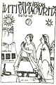 Guaman Poma 1615: "IDOLOS DE LOS INGAS INTI, UANACAURI, TAMBOTOCO" (Idolos de los Incas Inti, Wanakawri, Tampu T'uqu)

See also
References
- ^ PNUD-INDECI, Estudio del Mapa de Peligros de la Ciudad del Cusco, Proyecto: Ciudades Sostenibles. Cusco 2004 (in Spanish)
- ^ a b drc-cusco.gob.pe/ "Distrito de San Sebastián - Sitio Arqueológico de Wanakauri", retrieved on February 13, 2014(in Spanish)
- ^ escale.minedu.gob.pe - UGEL map of the Cusco Province (Cusco Region)
- ^ a b mincetur.gob.pe "Cerro Huanacaure", retrieved on February 13, 2014 (in Spanish)
- ^ PNUD-INDECI, Estudio del Mapa de Peigros de la Ciudad del Cusco, Proyecto: Ciudades Sostenibles. Cusco 2004 (in Spanish)
This Cusco Region geography article is a stub. You can help Wikipedia by expanding it. |