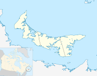
O'Leary, Prince Edward Island
Appearance
Town of O’Leary | |
|---|---|
Town | |
| Nickname: Hockeytown | |
Location of O'Leary in Prince Edward Island | |
| Coordinates: 46°42′25″N 64°13′50″W / 46.70694°N 64.23056°W | |
| Country | Canada |
| Province | Prince Edward Island |
| County | Prince County |
| Parish | Halifax |
| Government | |
| • Type | Town Council |
| • Mayor | Eric Gavin |
| • Deputy Mayor | Carol Ferguson |
| • Administrator | Beverley Shaw |
| • Councilors | Blake Adams Joey Dumville Marvin MacDonald Darren MacKinnon Tashia Maynard |
| Area | |
| • Total | 4.4 km2 (1.68 sq mi) |
| Elevation | 31 m (102 ft) |
| Population (2016)[1] | |
| • Total | 815 |
| • Density | 190/km2 (490/sq mi) |
| Canadian Postal code | |
| Area code | 902 |
| Telephone Exchange | 726 807 859 |
| NTS Map | 021I09 |
| GNBC Code | BABYS |
| Website | http://www.townofoleary.com/index.php |
O'Leary is a town located in Prince County, Prince Edward Island.[2] Its population in the 2016 Census was 815 people.[1]
Economy
The community's economy is tied to the potato farming industry. O'Leary is home to the Canadian Potato Museum.[3]
Climate
| Climate data for O'Leary | |||||||||||||
|---|---|---|---|---|---|---|---|---|---|---|---|---|---|
| Month | Jan | Feb | Mar | Apr | May | Jun | Jul | Aug | Sep | Oct | Nov | Dec | Year |
| Record high °C (°F) | 13.5 (56.3) |
13 (55) |
16.5 (61.7) |
21.5 (70.7) |
32.2 (90.0) |
33.5 (92.3) |
32.8 (91.0) |
32.5 (90.5) |
32.5 (90.5) |
24 (75) |
20 (68) |
13.9 (57.0) |
33.5 (92.3) |
| Mean daily maximum °C (°F) | −4.4 (24.1) |
−3.8 (25.2) |
0.7 (33.3) |
6.5 (43.7) |
14.3 (57.7) |
19.8 (67.6) |
23.2 (73.8) |
22.8 (73.0) |
18 (64) |
11.4 (52.5) |
5.1 (41.2) |
−1.2 (29.8) |
9.4 (48.9) |
| Mean daily minimum °C (°F) | −12.7 (9.1) |
−12.2 (10.0) |
−7 (19) |
−1.2 (29.8) |
4.3 (39.7) |
9.8 (49.6) |
13.8 (56.8) |
13.6 (56.5) |
9.5 (49.1) |
4.1 (39.4) |
−0.9 (30.4) |
−7.9 (17.8) |
1.1 (34.0) |
| Record low °C (°F) | −31 (−24) |
−29.4 (−20.9) |
−25.6 (−14.1) |
−13.9 (7.0) |
−6.1 (21.0) |
−1.1 (30.0) |
3.9 (39.0) |
3.3 (37.9) |
−1.1 (30.0) |
−6.7 (19.9) |
−15 (5) |
−27.2 (−17.0) |
−31 (−24) |
| Average precipitation mm (inches) | 97.1 (3.82) |
78.3 (3.08) |
89.4 (3.52) |
85.2 (3.35) |
95.6 (3.76) |
82.6 (3.25) |
100.1 (3.94) |
84.9 (3.34) |
99.7 (3.93) |
107.9 (4.25) |
110.2 (4.34) |
109.7 (4.32) |
1,140.7 (44.91) |
| Source: Environment Canada[4] | |||||||||||||
References
- ^ a b c "Census Profile, 2016 Census: O'Leary, Community [Census subdivision], Prince Edward Island". Statistics Canada. Retrieved 11 October 2019.
- ^ "Municipal Affairs and Provincial Planning". Department of Finance, Energy and Municipal Affairs. Retrieved 21 July 2013.
- ^ Canadian Potato Museum
- ^ Environment Canada Canadian Climate Normals 1971–2000, accessed 15 July 2009


