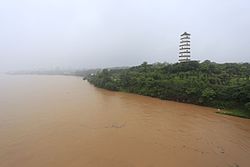
Gan River
Appearance
| Gan River | |
|---|---|
 Gan River and Yuhong Pagoda in Ganzhou | |
 | |
| Native name | 赣江 |
| Location | |
| Country | People's Republic of China |
| Province | Jiangxi |
| Physical characteristics | |
| Mouth | |
• location | Lake Poyang |
| Length | 885 km (550 mi) |
| Discharge | |
| • average | 1,667 m3/s (58,900 cu ft/s) |
The Gan River (simplified Chinese: 赣江; traditional Chinese: 贛江; pinyin: Gàn Jiāng, Gan: Kōm-kong) travels 885 km (550 mi) north through the western part of Jiangxi before flowing into Lake Poyang and thus the Yangtze River. The Xiang-Gan uplands separate it from the Xiang River of neighboring eastern Hunan.[1]
It is the major geographical feature of Jiangxi, and gives its name to the Gan variety of Chinese[2] as well as the province's one-character abbreviation.[3]
The river feeds into Lake Poyang, which in turns connects with the Yangtze.[4]
Tributaries
See also
References
- ^ Carol Benedict (2011). "Chinese Tobacco Production, 1600 to 1750". Golden-Silk Smoke: A History of Tobacco in China, 1550–2010. University of California Press. p. 41.
- ^ James Stuart Olson (1998). An Ethnohistorical Dictionary of China. Greenwood Press. p. 80. Retrieved 2 March 2019.
- ^ 高考地理:中国各省份简称历来 (in Simplified Chinese). Sohu Education. 2017-07-08. Retrieved 2018-12-17.
19、江西--地处长江中下游南岸,赣江是省内最大的河流,故简称"赣"
- ^ Stephen Turnbull (2002). "A Case Study of Chinese Fighting Ships". Fighting Ships of the Far East (1): China and Southeast Asia 202 BC-AD 1419. Osprey Publishing. p. 37.
External links
- . Collier's New Encyclopedia. 1921.
28°31′55″N 115°48′54″E / 28.532°N 115.815°E
