Calle-Calle River
| Calle-Calle River | |
|---|---|
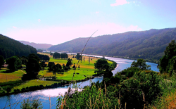
 View of Calle-Calle River a few kilometers upstream from Valdivia | |
| Native name | Río Calle-Calle Error {{native name checker}}: parameter value is malformed (help) |
| Location | |
| Country | Chile |
| Physical characteristics | |
| Source | |
| • location | San Pedro River |
| Mouth | |
• location | Valdivia River |
| Length | 55 km (34 mi)[1] |
Calle-Calle River (Mapudungun for lot of Iridaceaes) also called Gudalafquén in Mapudungun, is a river in Valdivia Province, southern Chile. It drains waters from the San Pedro River to the Valdivia River, which in turn flows into Corral Bay on the Pacific Ocean.
The Calle-Calle is among the few rivers in Chile that are considered navigable.
Calle-Calle Bridge crosses the river in the city of Valdivia.

References
- ^ "Cuenca del río Valdivia" (PDF). Archived from the original (PDF) on 2007-09-27. Retrieved 2007-10-28.
39°48′07″S 73°12′45″W / 39.80194°S 73.21250°W
