Tylers Green
This article needs additional citations for verification. (August 2013) |
| Tylers Green | |
|---|---|
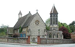
 St Margaret's parish church | |
Location within Buckinghamshire | |
| OS grid reference | SU905940 |
| Civil parish | |
| Unitary authority | |
| Ceremonial county | |
| Region | |
| Country | England |
| Sovereign state | United Kingdom |
| Post town | High Wycombe |
| Postcode district | HP10 |
| Dialling code | 01494 |
| Police | Thames Valley |
| Fire | Buckinghamshire |
| Ambulance | South Central |
| UK Parliament | |
| Website | Chepping Wycombe Parish Council |

Tylers Green is a village in the civil parish of Chepping Wycombe, Buckinghamshire, England.
The toponym is derived from the large tiling industry that used to exist here.[citation needed] In ancient times[when?] the village was known as Garrett or Gerrard Green. The village is in the Chiltern Hills and from here there are many walks through beech woodland which once supplied the furniture industry in High Wycombe.
The village is adjoined on one side by Hazlemere and on the other by Penn. "Penn and Tylers Green" are often referred to as one. Tylers Green centres on a village green where an annual fête is held. In one corner of the green is a duck pond.
The Church of England parish church of St Margaret is Grade II listed[1] was built in 1854 of flint and stone.[2] The wooden bell-turret was added in 1891.[2]
In 2006 Thames Valley Police cordoned off the woodland between Tylers Green, Totteridge, Micklefield and High Wycombe (Kingswood) for a fingertip search for evidence linked to the 2006 transatlantic aircraft plot. The woodland remained cordoned off for four months before being reopened in November 2006.[3]
References
- ^ https://www.historicengland.org.uk/listing/the-list/list-entry/1125628
- ^ a b Pevsner 1960, p. 271.
- ^ Penn and Tylers Green News Website Archived 2011-07-21 at the Wayback Machine
Sources and further reading
- Page, W.H., ed. (1925). A History of the County of Buckingham, Volume 3. Victoria County History. pp. 112–134.
- Pevsner, Nikolaus (1960). Buckinghamshire. The Buildings of England. Harmondsworth: Penguin Books. p. 271. ISBN 0-14-071019-1.
{{cite book}}: Invalid|ref=harv(help)
External links
- Penn and Tylers Green village website
- Penn and Tylers Green community website
- Penn & Tylers Green Cricket Club


