
Ishigaki Island
Native name: Ishigaki-jima (石垣島) | |
|---|---|
 | |
 Ishigaki Island | |
| Geography | |
| Location | Pacific Ocean |
| Archipelago | Yaeyama Islands |
| Area | 222.24[1] km2 (85.81 sq mi) |
| Highest elevation | 525.5 m (1724.1 ft) |
| Highest point | Mount Omoto |
| Administration | |
| Prefecture | Okinawa Prefecture |
| Demographics | |
| Population | 47,564[1] (January 2019) |


Ishigaki Island (石垣島, Ishigaki-jima, Yaeyama: Ishanagï, Okinawan: Ishigachi), also known as Ishigakijima, is a Japanese island south-west of Okinawa Hontō and the second-largest island of the Yaeyama Island group. It is located approximately 411 kilometers south-west of Okinawa Hontō.[1] It is within the City of Ishigaki in Okinawa Prefecture. The city functions as the business and transport center of the archipelago. The island is served by New Ishigaki Airport, the largest airport in the Yaeyamas.
Much of the island and surrounding waters including Mount Omoto and Kabira Bay are protected as part of Iriomote-Ishigaki National Park.[2]
Ishigaki Island, like the rest of Okinawa, is culturally influenced by both Japan and Taiwan due to its location, about 300 km off the north eastern coast of Taiwan.
History
A tsunami of record height hit Ishigaki Island in 1771.[3]
The island provided the scene for the arrest of one of the perpetrators of Aum Shinrikyo's sarin gas attack, Yasuo Hayashi, 21 months after and 2000 km away from where the crime took place.
Ishigaki Port will be expanded so that five large Japanese Coast Guard patrol boats can be stationed there.[4] The JSDF is also considering deploying short range anti-ship missiles[5] (possibly the Type 96 Multi-Purpose Missile System) on the island.
These reinforcements are mostly in relation to the Japanese uninhabited Senkaku Islands, which lie 170 km north of Ishigaki and are under the control of the mayor of Ishigaki, which has been given civic authority over the territory since the Senkaku Islands reverted from the US to the Japanese government control in 1972. China (People's Republic of China) and Taiwan (Republic Of China) have challenged Japan's sovereignty over these Senkaku Islands since 1972, with more intensity since 2012.
Culture
Food
Ishigaki has a very different cuisine from mainland Japan. Due to the relative warmth of the surrounding sea and due to various cultural influences, the food of Ishigaki is more meat-centered than the rest of Japan. For example, Tonsoku (pigs feet) are quite popular. The usage of Spam is also widespread and featured in many different dishes.
Gallery
-
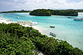
 Ishigaki Bay, seen from Southern Gate Bridge.
 -
-
 Ishigaki Island from space, August 1991
 -
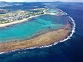
 Hirakubo Peninsula
 -
 Shiraho coral reef (2018)
 -
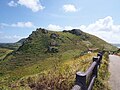 Hirakubo
 -
 Hirakubosaki lighthouse, Ishigakijima
 -
 Japan Coast Guard vessels at Port of Ishigaki


See also
References
- ^ a b c "Remote island related materials (離 島 関 係 資 料)" (PDF). Archived (PDF) from the original on 2020-02-15. Retrieved 2020-02-15.
- ^ "Introducing places of interest: Iriomote-Ishigaki National Park (Ishigakijima)". Ministry of the Environment. Archived from the original on 20 April 2012. Retrieved 15 February 2012.
- ^ 「宮古八重山津波」(1771 年) における災害・年貢・復興について —石垣島と多良間島を中心に—」 豊見山和行 (Tomiyama, Kazuyuki) University of the Ryukyus Repository (Retrieved on May 13, 2009) (in Japanese) Index (Retrieved on May 13, 2009)
- ^ "Japan Coast Guard to form 600-member unit tasked solely with patrolling Senkakus."
- ^ Self-Defense Forces gear up for large-scale war games on remote isle (The Japan Times/AFP-JIJI)
External links
- English / Dutch guide for Ishigaki island
- Ishigaki island vacation activities - english
- English language guide to Ishigaki island
- Ishigaki City official website
| Core city | ||
|---|---|---|
| Cities | ||
| Districts | ||
24°26′N 124°13′E / 24.44°N 124.22°E
| International | |
|---|---|
| National | |