
Point Place (Toledo, Ohio)
This article needs additional citations for verification. (August 2014) |

Point Place is a neighborhood in North Toledo, Ohio.[1] Point Place was originally part of Washington Township, Lucas County in the 1800s,[2] and was annexed into the city of Toledo, Ohio in 1937.[3] Point Place is surrounded by the Ottawa River, Lake Erie, the Maumee Bay and the Maumee River.
Transportation

Point Place is near two major interstates, I-75, and I-280, which connects to I-80 (I-80/90). Summit Street runs through the middle of Point Place, and serves as the major center of commerce.
Parks
- Cullen Park
- Detwiler Park
- Edgewater Park
- Friendship Park
- Harry Kessler Park
- Shoreland Park
-
 The empty public pool at Detwiler Park in Point Place Ohio.
 -
 Harry Kessler Park Signage
 -
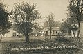 Friendship Park in 1910
 -
 Friendship Park in 1910
 -
 Bay Park in 1913


.jpg)
.jpg)
.jpg)
References
41°43′08″N 83°28′46″W / 41.7188889°N 83.4794444°W
This Lucas County, Ohio state location article is a stub. You can help Wikipedia by expanding it. |