Schilde
Appearance
Schilde | |
|---|---|
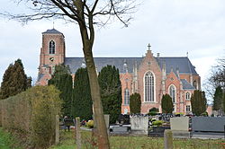
 Sint-Guibertus church | |
| Coordinates: 51°14′N 04°34′E / 51.233°N 4.567°E | |
| Country | |
| Community | Flemish Community |
| Region | Flemish Region |
| Province | Antwerp |
| Arrondissement | Antwerp |
| Government | |
| • Mayor | Dirk Bauwens (N-VA) |
| • Governing party/ies | VLD, CD&V |
| Area | |
| • Total | 36.09 km2 (13.93 sq mi) |
| Population (2018-01-01)[1] | |
| • Total | 19,585 |
| • Density | 540/km2 (1,400/sq mi) |
| Postal codes | 2970 |
| NIS code | 11039 |
| Area codes | 03 |
| Website | www.schilde.be |
Schilde (Dutch pronunciation: [ˈsxɪldə]) is a municipality located in the Belgian province of Antwerp. The municipality comprises the towns of Schilde proper and 's-Gravenwezel. On January 1, 2006 Schilde had a total population of 19,575. The total area is 35.99 km² which gives a population density of 544 inhabitants per km². It has one of the highest per capita income levels in Flanders.
References
- ^ "Wettelijke Bevolking per gemeente op 1 januari 2018". Statbel. Retrieved 9 March 2019.
External links
 Media related to Schilde at Wikimedia Commons
- Official website (in Dutch)


