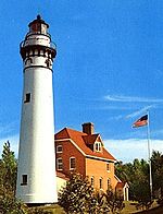
Manitowoc Breakwater Light
Appearance
 Manitowoc Breakwater Lighthouse | |
 | |
| Location | Manitowoc, Wisconsin |
|---|---|
| Coordinates | 44°05′33.918″N 87°38′36.91″W / 44.09275500°N 87.6435861°W[1] |
| Tower | |
| Constructed | 1918 |
| Foundation | Pier |
| Construction | Steel |
| Automated | 1971 |
| Height | 40 feet (12 m) |
| Shape | Cylindrical on square fog signaling building |
| Light | |
| First lit | 1918 |
| Focal height | 16 m (52 ft) |
| Lens | Fourth order Fresnel lens |
| Range | 13 nautical miles (24 km; 15 mi)[1] |
| Characteristic | White, Isophase, 6 sec[1] |
The Manitowoc Breakwater Light is a Lake Michigan lighthouse located near Manitowoc in Manitowoc County, Wisconsin, at the end of the north pier defining Manitowoc's harbor.
It is not to be confused with the smaller and complementary south pier navigational beacon, which was unmoored and swept out into the lake on January 7, 2019, during a period of heavy waves and lakeshore flooding from gusty winds. The beacon will be replaced as soon as possible.[2][3]


Notes
- ^ a b c Light List, Volume VII, Great Lakes (PDF). Light List. United States Coast Guard. 2014.
- ^ Zarling, Patti (7 January 2019). "Manitowoc South Pier beacon swept away near lighthouse in high waves on Lake Michigan". Herald Times Reporter. Retrieved 7 January 2019.
- ^ "U.S. Lighthouse in Lake Michigan washed away by large waves" (Videos). ABC News. January 8, 2019. Retrieved January 8, 2019.
Further reading
- Havighurst, Walter (1943) The Long Ships Passing: The Story of the Great Lakes, Macmillan Publishers.
- Oleszewski, Wes, Great Lakes Lighthouses, American and Canadian: A Comprehensive Directory/Guide to Great Lakes Lighthouses, (Gwinn, Michigan: Avery Color Studios, Inc., 1998) ISBN 0-932212-98-0.
- Pepper, Terry. "Seeing the Light: Lighthouses on the western Great Lakes".
- Sapulski, Wayne S., (2001) Lighthouses of Lake Michigan: Past and Present (Paperback) (Fowlerville: Wilderness Adventure Books) ISBN 0-923568-47-6; ISBN 978-0-923568-47-4.
- Wright, Larry and Wright, Patricia, Great Lakes Lighthouses Encyclopedia Hardback (Erin: Boston Mills Press, 2006) ISBN 1-55046-399-3.
External links
- Seeing the light
- Lighthouse friends article
- NPS Inventory of Historic Light Stations - Wisconsin
- Rowlett, Russ. "Lighthouses of the United States: Eastern Wisconsin". The Lighthouse Directory. University of North Carolina at Chapel Hill.
- "Historic Light Station Information and Photography: Wisconsin". United States Coast Guard Historian's Office. Archived from the original on 2017-05-01.
- Light List, Volume VII, Great Lakes (PDF). Light List. United States Coast Guard.

