Thingangyun Township
Thingangyun Township
သင်္ဃန်းကျွန်း မြို့နယ် | |
|---|---|
Township of Yangon | |
| Thingangyun Township | |
 | |
| Coordinates: 16°49′41″N 96°11′3″E / 16.82806°N 96.18417°E | |
| Country | Myanmar |
| Division | Yangon |
| City | Yangon |
| Township | Thingangyun |
| Area | |
| • Total | 11.5 km2 (4.44 sq mi) |
| Population (2000) | |
| • Total | 170,000 |
| • Density | 15,000/km2 (38,000/sq mi) |
| Time zone | UTC6:30 (MST) |
| Postal codes | 11071, 11072 |
| Area code(s) | 1 (mobile: 80, 99) |
| YCDC[1] | |
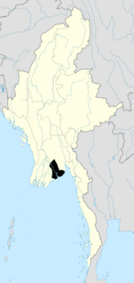
Thingangyun Township (Burmese: သင်္ဃန်းကျွန်း မြို့နယ်; MLCTS: sangghan:kywan: mrui.nai, pronounced [θɪ̀ɰ̃ɡáɰ̃dʑʊ́ɰ̃ mjo̰nɛ̀]) is located in the eastern part of Yangon, Myanmar. The township comprises 38 wards, and shares borders with South Okkalapa township in the north, North Dagon township in the east, Yankin township and Tamwe township in the west, and Thaketa township in the south. The township has 40 primary schools, four middle schools and five high schools.[1]
The township is home to Thingangyun Education College and University of Dental Medicine, Yangon.
The city's main sporting venues, the Thuwunna Stadium and the Thuwunna Indoor Stadium are located on the western side of the township.
Landmarks
The following is a list of landmarks protected by the city in Thingangyun township.[2]
| Structure | Type | Address |
|---|---|---|
| Kyaikkasan Pagoda | Pagoda | Kyaikkasan Pagoda Road |
| St. Joseph's Church | Church | 1-3 Thiri Marla Road |
| Thanyok Monastery | Monastery | Kyauksadaing Road |
| Sitthi Vinayagar (Maha Pain Nae) Hindu Temple | Tamil Hindu Temple | Bawga Street, GhaNge Ward. |
| Shree Krishna Temple | Tamil Hindu Temple | Kha Kwe Ward |
| Arulmigu Maari Amman Aalayam | Tamil Hindu Temple | Hnin Si Kone |
References
- ^ a b "Thingangyun Township". Yangon City Development Committee. Archived from the original on 2 October 2011. Retrieved 2009-03-15.
- ^ "Special Reports: Heritage List". The Myanmar Times. 2001-10-29. Archived from the original on 15 June 2009.


