Carreño
Appearance
Carreño | |
|---|---|
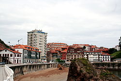
 View over Candás | |
 Location of Carreño | |
| Coordinates: 43°32′55″N 5°47′23″W / 43.54861°N 5.78972°W | |
| Country | |
| Autonomous community | |
| Province | Asturias |
| Comarca | Gijón |
| Capital | Candás |
| Government | |
| • Alcalde | Manuel Ángel Riego (PSOE) |
| Area | |
• Total | 66.70 km2 (25.75 sq mi) |
| Elevation | 0 m (0 ft) |
| Population (2018)[1] | |
• Total | 10,444 |
| • Density | 160/km2 (410/sq mi) |
| Time zone | UTC+1 (CET) |
| • Summer (DST) | UTC+2 (CEST) |
| Postal code | 33430 |
| Official language(s) | Asturian |
| Website | Official website |
Carreño is a municipality in the autonomous community of the Principality of Asturias, Spain. It is bordered by Corvera de Asturias on the west, Gozón on the north, the Cantabrian Sea on the north and east, and Gijón on the east and south. Its capital is Candás.
History
| Year | Pop. | ±% p.a. |
|---|---|---|
| 1842 | 4,982 | — |
| 1860 | 6,052 | +1.09% |
| 1877 | 6,271 | +0.21% |
| 1887 | 7,091 | +1.24% |
| 1900 | 7,533 | +0.47% |
| 1910 | 8,962 | +1.75% |
| 1920 | 8,876 | −0.10% |
| 1930 | 10,256 | +1.46% |
| 1940 | 10,009 | −0.24% |
| 1950 | 9,931 | −0.08% |
| 1960 | 11,128 | +1.14% |
| 1970 | 11,529 | +0.35% |
| 1980 | 11,470 | −0.05% |
| 1990 | 11,009 | −0.41% |
| 2000 | 10,557 | −0.42% |
| 2001 | 10,567 | +0.09% |
| 2002 | 10,527 | −0.38% |
| 2003 | 10,431 | −0.91% |
| 2004 | 10,435 | +0.04% |
| 2005 | 10,716 | +2.69% |
| 2006 | 10,842 | +1.18% |
| 2007 | 10,826 | −0.15% |
| Source: Instituto Nacional de Estadística de España | ||
As characteristic of other sites in Asturias, artifacts from the Neolithic era were also found in Carreño. Tumuli, dolmens and hill forts in the region provide evidence for the 100,000-year-old history of the area.
Parishes

(The number preceding the parish name refers to its location on the parroquias map)
- Candás (capital)
- Perlora
- Albandi
- Carrió
- Pervera (Asturian: Prevera)
- Prendes (Asturian: Priendes)
- Piedeloro (Asturian: Pieloro)
- Logrezana (Asturian: Llorgozana)
- Guimarán
- El Valle
- Ambás
- Tamón
Politics
| Partido | 1979 | 1983 | 1987[2] | 1991[2] | 1995[2] | 1999[2] | 2003[2] | 2007[2] | 2011[3] | 2015[2] |
| FSA-PSOE | 4 | 3 | 3 | 3 | 4 | 7 | 5 | 6 | 6 | 6 |
| CD / AP / PP | 1 | 4 | 2 | 3 | 5 | 4 | 3 | 4 | 4 | 4 |
| Somos | 4 | |||||||||
| PCE / IU-BA / IU-The Greens | 5 | 10 | 9 | 10 | 7 | 3 | 3 | 2 | 1 | 3 |
| BA | 1 | |||||||||
| Unidá | ||||||||||
| FAC | 2 | 0 | ||||||||
| UICA | 4 | 3 | 1 | |||||||
| CA-UN | 1 | 0 | ||||||||
| PCPE | 0 | 1 | 0 | |||||||
| URAS | 3 | 1 | 1 | 0 | ||||||
| PAS-UNA / PAS / URAS-PAS | 0 | 0 | 0 | 0 | ||||||
| UCD / CDS | 5 | 0 | 3 | 1 | ||||||
| CAS | 1 | |||||||||
| AA / Andecha por Carreño | 0 | 0 | 1 | 1 | ||||||
| Independents | 2 | |||||||||
| Total | 17 | 17 | 17 | 17 | 17 | 17 | 17 | 17 | 17 | 17 |
Culture

- La iglesia de San Félix church built under Fruela II in the 9th century
- La iglesia de Santa María de Logrezana church finished in the 19th century.
- La iglesia de Santa María de Piedeloro church built in the 13th century
- La iglesia parroquial de Ambás parish church from the 18th century
- La ermita de San Antonio hermitage from the 16th century
- El palacio de Estrada Mora palace from the 16th century
Notable people
- Antón de Marirreguera, 17th-century writer, and one of the first to write in Asturian.
- Juan Carreño de Miranda (March 1614 - September 1685) was a Spanish painter of the Baroque period.
References
- ^ Municipal Register of Spain 2018. National Statistics Institute.
- ^ a b c d e f g Dirección General de Política Interior
- ^ Elecciones Locales 2011
External links
- Ayuntamiento de Carreño
- Diario de noticias e información sobre Candás y Carreño (in Spanish)
- Federación Asturiana de Concejos (in Spanish)
- Página web sobre Candás (in Spanish)


