Purunllacta, Soloco
Appearance
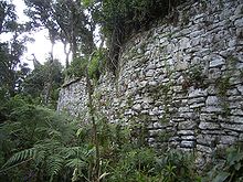
 A wall of the fortress in Soloco | |
| Location | Peru |
|---|---|
| Region | Amazonas Region, Chachapoyas Province, Soloco District |
Purunllacta[1] or Purum Llacta[2] (possibly from Quechua purum, purun savage, wild / wasteland, llaqta place (village, town, city, country, nation)[3][4] is an archaeological site in Peru. It is situated in the Amazonas Region, Chachapoyas Province, Soloco District, southwest and near the archaeological site of Purum Llaqta of the Cheto District.[2]
See also
References
- ^ Crandall, James (2016). "Household Practice and Spatial Fashioning in the Chachapoya Community of Purunllacta de Soloco". The 81st Annual Meeting of the Society for American Archaeology, Orlando, Florida.
- ^ a b Olivier Fabre, Jean Loup Guyot, Rodolfo Salas Gismondi, Manuel Malaver Pizarro, Ermanno Maniero, Los chachapoya de la región de Soloco: Chaquil, del sitio de hábitat a la cueva funeraria, Bulletin de l’Institut Français d’Études Andines / 2008, 37 (2): 271-292. Retrieved on March 29, 2014
- ^ Teofilo Laime Ajacopa, Diccionario Bilingüe Iskay simipi yuyayk'ancha, La Paz, 2007 (Quechua-Spanish dictionary)
- ^ Diccionario Quechua - Español - Quechua, Academía Mayor de la Lengua Quechua, Gobierno Regional Cusco, Cusco 2005 (Quechua-Spanish dictionary)

