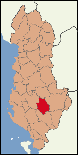
Skrapar District
Appearance
Skrapar District
Rrethi i Skraparit | |
|---|---|
 | |
| Coordinates: 40°33′N 20°15′E / 40.550°N 20.250°E | |
| Country | |
| Dissolved | 2000 |
| Seat | Çorovodë |
| Area | |
• Total | 775 km2 (299 sq mi) |
| Population (2001) | |
• Total | 29,874 |
| • Density | 39/km2 (100/sq mi) |
| Time zone | UTC+1 (CET) |
| • Summer (DST) | UTC+2 (CEST) |
Skrapar District (Template:Lang-sq) was one of the thirty-six districts of Albania (which were dissolved in 2000). It had a population of 29,874 in 2001, and an area of 775 km².[1] It was in the centre of the country, and its capital was Çorovodë. Its territory is now part of Berat County: the municipalities of Skrapar and Poliçan (partly). It is most famous for Skrapar Raki, a traditional brandy consumed by many Albanians.
Administrative divisions
The district consisted of the following municipalities:[2]
Notable people
- Abas Ermenji, Albanian politician and historian
- Riza Cerova, Albanian political figure
- Xhelal bej Koprencka, modern Albania's founding father
- Ilir Meta, Albanian politician
Gallery
References
- ^ Districts of Albania, statoids.com
- ^ "Portraits of poverty and inequality in Albania" (PDF). World Bank Group. 2016. pp. 33–40.
External links


