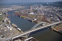
Fremont Bridge (Portland, Oregon)
Fremont Bridge | |
|---|---|
 | |
| Coordinates | 45°32′16″N 122°40′57″W / 45.5377083°N 122.6825027°W |
| Carries | Four lanes, two decks |
| Crosses | Willamette River and surface streets |
| Locale | Portland, Oregon |
| Official name | Fremont Bridge |
| Maintained by | Oregon Department of Transportation |
| ID number | 02529 |
| Characteristics | |
| Design | Tied-arch bridge |
| Total length | 2,154 ft (656.5 m) |
| Height | 381 ft (116.1 m) |
| Longest span | 1,255 ft (382.5 m) longest in Oregon |
| Clearance above | 18.3 ft (5.58 m) |
| Clearance below | 175 ft (53.3 m) |
| History | |
| Opened | November 15, 1973[1] |
| Location | |
 | |
The Fremont Bridge is a steel tied-arch bridge over the Willamette River located in Portland, Oregon, United States. It carries Interstate 405 and US 30 traffic between downtown and North Portland where it intersects with Interstate 5. It has the longest main span of any bridge in Oregon and is the second longest tied-arch bridge in the world (after Caiyuanba Bridge across the Yangtze River, China).[2] The bridge was designed by Parsons, Brinckerhoff, Quade and Douglas, and built by Murphy Pacific Corporation.[3]
The bridge has two decks carrying vehicular traffic, each with four lanes. The upper deck is signed westbound on US 30 and southbound on I-405. The lower deck is signed eastbound on US 30 and northbound on I-405.
Design and construction
Due to the public's dissatisfaction with the appearance of the Marquam Bridge, the Portland Art Commission was invited to participate in the design process of the Fremont. The improvement in visual quality resulted in a bridge that was nearly six times as expensive as the purposely economical Marquam Bridge. Designers modeled the bridge after the original 1964 Port Mann Bridge in Vancouver, British Columbia.
The steel tie-girder (I-beam) is 18 feet (5.5 m) tall and 50 inches (130 cm) wide. On October 28, 1971, while still under construction, a six-foot-long (1.8 m) crack was found on the west span of this girder that required a $5.5 million redesign and repair. The ramps and approaches are steel box girders. If the lanes of the bridge were placed end-to-end, there are 3.27 lane-miles (5.26 lane-km) on the arch bridge and 14.12 lane-miles (22.72 lane-km) on the ramps and approaches.[3]
The center span of the bridge, where the rib of the arch is above the deck, is 902 feet (275 m) long.[3] It was fabricated in California then assembled at Swan Island, 1.7 miles (2.7 km) downstream.[2] After assembly it was floated on a barge the 1.7 mile trip to the construction site.[3] On March 16, 1973, the 6,000 short tons (5,400 t) steel arch span was lifted 170 ft (52 m) using 32 hydraulic jacks. At the time, it was listed in the Guinness Book of World Records as the heaviest lift ever completed.[4]
The bridge was opened on November 15, 1973,[1][2] at a final cost of $82 million (equivalent to $617 million in 2023),[2] most of which was financed by the Federal Highway Administration. In 1976, an American flag and an Oregon flag were added atop the structure as part of the bicentennial celebration for the United States.[5] The flags were installed with the use of a helicopter.[3] The 15-by-25-foot (4.6 m × 7.6 m) flags are attached to 50-foot (15 m) tall flagpoles at the crest of the arches.[5]
Falcon nest
The Fremont Bridge was also the 26th Peregrine falcon nest site designated in Oregon in 1995 after the raptor was placed on the U.S. Threatened and Endangered Species list in 1970.[6]
Etymology
The bridge as well as Portland's associated Fremont Street were named for John C. Fremont (1813–1890). Fremont was an early explorer of the Oregon Country. He served in the United States Army at the time as a Captain and later promoted to General. In 1856, he ran for president, but was defeated by James Buchanan.[7]
Gallery
See also
References
- ^ a b "Fremont Bridge opens with wheeze". The Oregonian, November 16, 1973, p. 22.
- ^ a b c d Wood, Sharon; Wortman, Ed (2006). The Portland Bridge Book (3rd ed.). Urban Adventure Press. pp. 23–30. ISBN 0-9787365-1-6.
- ^ a b c d e Bottenberg, Ray (2007). Bridges of Portland. Arcadia Publishing. pp. 105–116. ISBN 9780738548760.
- ^ Smith, Dwight A. (1989). Historic Highway Bridges of Oregon. Oregon Historical Society Press. p. 300. ISBN 0-87595-205-4.
- ^ a b "News Q&A", The Oregonian, May 1, 2005.
- ^ "Fremont Bridge Peregrines: A Decade of Successful Nesting". Audubon Society of Portland. Retrieved January 11, 2010.
- ^ Snyder, Eugene E.. Portland Names and Neighborhoods: Their Historic Origin. Portland: Binford & Mort, 1979. p.133.
External links
- Historic American Engineering Record (Library of Congress) Fremont Bridge, Spanning Willamette River, Portland, Multnomah County, OR
- Fremont Bridge at Structurae
- Bridges in Portland, Oregon
- Bridges completed in 1973
- U.S. Route 30
- Bridges over the Willamette River
- Tied arch bridges in the United States
- Road bridges in Oregon
- Bridges on the Interstate Highway System
- 1973 establishments in Oregon
- Pearl District, Portland, Oregon
- Northwest District, Portland, Oregon
- Eliot, Portland, Oregon
- Overlook, Portland, Oregon
- Bridges of the United States Numbered Highway System
- Interstate 5
- Steel bridges in the United States
- Girder bridges in the United States


