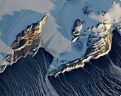
Terra Nova Bay

Terra Nova Bay is a bay which is often ice free, about 64 km (40 mi) long, lying between Cape Washington and the Drygalski Ice Tongue along the coast of Victoria Land, Antarctica.[1] It was discovered by the British National Antarctic Expedition (known as the Discovery Expedition) under Robert Falcon Scott, 1901–1904, and named by him after Terra Nova, one of the relief ships for the expedition.[1] The Italian permanent Zucchelli Station is located in the bay, as is the Jang Bogo Station of South Korea.
Antarctic Specially Protected Area
A marine area of 29.4 km2 of the bay comprising a narrow strip of coastal waters about 9.4 km long, to the immediate south of Zucchelli Station, and extending to a maximum of 7 km from the shore, has been designated an Antarctic Specially Protected Area (ASPA 161). It is an important site for long-term research on the marine ecology of benthic communities. As well as rich and complex sponge and anthozoan communities, the site supports a colony of Adélie penguins at Adélie Cove.[2]
References
- ^ a b "Terra Nova Bay". Geographic Names Information System. United States Geological Survey, United States Department of the Interior.
- ^ "Terra Nova Bay, Ross Sea" (PDF). Management Plan for Antarctic Specially Protected Area No. 161: Measure 14, Annex. Antarctic Treaty Secretariat. 2008. Retrieved 2013-09-21.
74°50′0″S 164°30′0″E / 74.83333°S 164.50000°E


