
Bow Lake (Alberta)
| Bow Lake | |
|---|---|
 Bow Lake, Crowfoot Glacier, et al | |
| Location | Banff National Park, Alberta |
| Coordinates | 51°39′52″N 116°26′55″W / 51.66444°N 116.44861°W |
| Lake type | Glacial Lake |
| Primary inflows | Bow River |
| Primary outflows | Bow River |
| Basin countries | Canada |
| Max. length | 3.2 km (2.0 mi) |
| Max. width | 1.2 km (0.75 mi) |
| Surface area | 3.21 km2 (1.24 sq mi) |
| Surface elevation | 1,920 m (6,300 ft) |
Bow Lake is a small lake in western Alberta, Canada. It is located on the Bow River, in the Canadian Rockies, at an altitude of 1920 m.
The lake lies south of the Bow Summit, east of the Waputik Range (views including Wapta Icefield, Bow Glacier, Bow Peak, Mount Thompson, Crowfoot Glacier and Crowfoot Mountain) and west of the Dolomite Pass, Dolomite Peak and Cirque Peak.
Bow Lake is one of the lakes that line the Icefields Parkway in Banff National Park and Jasper National Park, other such lakes being Hector Lake, Lake Louise, Peyto Lake, Mistaya Lake, Waterfowl Lakes, Chephren Lake and Sunwapta Lake.[1]
Historical Simpson's Num-Ti-Jah Lodge is located on the shores of Bow Lake at the foot of Mount Jimmy Simpson.[2]
Bow Lake is the closest lake to the headwaters of Bow River, and has a total area of 3.21 km². Water in the lake is meltwater of the Bow Glacier and its turquoise colouring is due to glacial till.
Image gallery
-
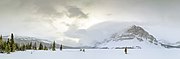 Bow Lake panorama in winter
 -
 A view of Bow Lake and Crowfoot Mountain
 -
 Bow Lake at a roadside turnout on Alberta Highway 93
 -
 Bow Lake in late May


See also
References
- ^ Canadian Rockies (1996). "The Icefields Parkway". Retrieved 2009-05-14.
- ^ Tim Whyte
| Rivers |  | |
|---|---|---|
| Waterfalls | ||
| Lakes | ||
| Reservoirs | ||
| Glaciers | ||
| Other | ||
| International | |
|---|---|
| National | |
This Alberta's Rockies location article is a stub. You can help Wikipedia by expanding it. |