
Mackenzie, British Columbia
Mackenzie | |
|---|---|
| District of Mackenzie[1] | |
 Mackenzie seen from Morfee Mountain | |
| Nickname: "Mack-Town" | |
 Mackenzie Location of Mackenzie in British Columbia  Mackenzie Mackenzie (Canada) | |
| Coordinates: 55°20′17″N 123°05′40″W / 55.33806°N 123.09444°W | |
| Country | Canada |
| Province | British Columbia |
| Regional District | Fraser-Fort George |
| Incorporated | 1966 |
| Government | |
| • Mayor | Joan Atkinson |
| • Governing body | District of Mackenzie Municipal Council |
| • MP (Prince George-Peace River) | Bob Zimmer |
| • MLA (Prince George-Mackenzie) | Mike Morris |
| Area | |
| • Total | 159.09 km2 (61.42 sq mi) |
| Elevation | 700 m (2,300 ft) |
| Population (2016) | |
| • Total | 3,714 |
| • Density | 22.6/km2 (59/sq mi) |
| Time zone | UTC−08:00 (PST) |
| Postal code span | |
| Area code | 250 / 778 / 236 |
| Highways | |
| Website | districtofmackenzie |
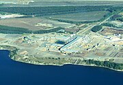
Mackenzie is a district municipality within the Fraser-Fort George Regional District in central British Columbia, Canada. The community is located at the south end of Williston Lake. The townsite, established by Alexandra Forest Industries (acquired by BC Forest Products in 1967) and Cattermole Timber (partnered with Jujo Paper in 1970 to create Finlay Forest Industries), was named for Sir Alexander MacKenzie (1764–1820). Mackenzie's main industries are logging, lumber, market pulp and tourism. Duz Cho Logging, sawmills, such as the Canfor Corporation Mackenzie sawmill (successor to BCFP's lumber division) and Conifex Timber,[2] (successor to FFI) and the Paper Excellence[3] kraft pulp mill (successor to BCFP's pulp division), are major employers in town. As of July 2019, Canfor sawmill ceased production indefinitely as part of a province-wide curtailment of operations. The nearby Thompson Creek Metals Mount Milligan copper-gold operation[4] provides secondary economic activity for the town.
Recreation
Mackenzie is a destination for outdoor sports enthusiasts. In the winter, Mackenzie hosts dog sled racing, cross-country skiing, and snowmobiling competitions, and maintains 32km of groomed cross-country ski trails. Morfee Mountain overlooks Mackenzie and is a popular destination for local hiking and an off-road vehicle destination. Mackenzie has a swimming pool, indoor skating rink, a curling rink, and two developed beaches on Morfee Lake; First Beach is used primarily for recreational swimming, and Second Beach includes a boat launch. Mackenzie is home to Little Mac Ski Hill, a small local ski hill and mountain bike park just east of the main town and is 45 minutes away from Powder King ski resort. The surrounding area has several lakes that are popular for fishing and a healthy wildlife population makes Mackenzie a popular hunting destination.

Mackenzie Golf and Country Club is a challenging, semi-private, nine-hole golf course with a driving range and is within walking distance of most of the town, including the RV park.
Community facilities
Community facilities include a recreation centre that houses the public library, gym, swimming pool, ice rink, and community hall. There is also an art centre, a museum, two shopping malls and two schools: Mackenzie Secondary School (which also serves McLeod Lake), and Morfee Elementary School. The schools are operated by the Prince George School District (No. 57).
Mackenzie also has several religious establishments, including a Sikh temple, St. Peter's Catholic,[5] Mackenzie Baptist and Hope Trinity (converging the Anglican, Lutheran and United faiths) churches and Living Joy Christian Centre.[6]
Mackenzie has been served by CHMM-FM, a not-for-profit radio station since 2003.
Mackenzie has its own Royal Canadian Mounted Police detachment, a provincial courtroom, a volunteer fire department, and a municipal hospital.
Transportation
Mackenzie is located on Highway 39, 28 km (17 mi) from Highway 97. There is scheduled bus service to Chetwynd and Prince George. It is served by a small airport. There is no scheduled passenger service but charter services are available.[7]
Tourist attractions

Mackenzie is less than 10 km (6.2 mi) east of Williston Lake reservoir, the largest man-made lake in British Columbia.[8] Mackenzie is also home of the world's largest tree crusher.
Famous people from Mackenzie
- Turner Stevenson – Former National Hockey League player
- Leah Callahan – Canadian Olympic Wrestler (London 2012)
Climate
Mackenzie has a subarctic climate that has influences from the Pacific Ocean resulting in less cold winters than expected for its northerly latitude compared to other Canadian locations. It has warm summer days, but the cool nights ensure that only three months go above 10 °C (50 °F) in mean temperatures. Winters are very cold on occasion, although relatively short for a subarctic climate with a January mean of −9.2 °C (15.4 °F) as the coldest month.
| Climate data for Mackenzie Airport | |||||||||||||
|---|---|---|---|---|---|---|---|---|---|---|---|---|---|
| Month | Jan | Feb | Mar | Apr | May | Jun | Jul | Aug | Sep | Oct | Nov | Dec | Year |
| Record high humidex | 9.2 | 9.9 | 14.9 | 23.8 | 31.4 | 31.9 | 36.0 | 35.5 | 32.3 | 23.7 | 12.4 | 8.4 | 36.0 |
| Record high °C (°F) | 9.8 (49.6) |
11.1 (52.0) |
16.3 (61.3) |
24.4 (75.9) |
34.6 (94.3) |
31.9 (89.4) |
35.0 (95.0) |
35.0 (95.0) |
30.7 (87.3) |
23.0 (73.4) |
13.3 (55.9) |
8.3 (46.9) |
35.0 (95.0) |
| Mean daily maximum °C (°F) | −5.6 (21.9) |
−3.0 (26.6) |
3.3 (37.9) |
9.7 (49.5) |
16.0 (60.8) |
20.2 (68.4) |
22.2 (72.0) |
21.5 (70.7) |
15.2 (59.4) |
7.6 (45.7) |
−1.2 (29.8) |
−4.8 (23.4) |
8.4 (47.1) |
| Daily mean °C (°F) | −9.2 (15.4) |
−7.7 (18.1) |
−2.7 (27.1) |
3.3 (37.9) |
8.9 (48.0) |
13.3 (55.9) |
15.2 (59.4) |
14.3 (57.7) |
9.1 (48.4) |
3.3 (37.9) |
−4.3 (24.3) |
−8.2 (17.2) |
2.9 (37.2) |
| Mean daily minimum °C (°F) | −12.9 (8.8) |
−12.3 (9.9) |
−8.5 (16.7) |
−3.2 (26.2) |
1.8 (35.2) |
6.4 (43.5) |
8.2 (46.8) |
7.0 (44.6) |
3.0 (37.4) |
−1.1 (30.0) |
−7.4 (18.7) |
−11.6 (11.1) |
−2.6 (27.3) |
| Record low °C (°F) | −44.5 (−48.1) |
−43.8 (−46.8) |
−40.0 (−40.0) |
−25.6 (−14.1) |
−8.9 (16.0) |
−4.0 (24.8) |
−1.0 (30.2) |
−4.3 (24.3) |
−8.9 (16.0) |
−21.5 (−6.7) |
−35.6 (−32.1) |
−45.1 (−49.2) |
−45.1 (−49.2) |
| Record low wind chill | −52.8 | −43.1 | −42.8 | −24.4 | −14.7 | −3.2 | 0.0 | −4.8 | −10.8 | −29.5 | −48.0 | −50.4 | −52.8 |
| Average precipitation mm (inches) | 70.5 (2.78) |
45.6 (1.80) |
32.6 (1.28) |
30.6 (1.20) |
48.0 (1.89) |
56.9 (2.24) |
61.8 (2.43) |
49.0 (1.93) |
52.4 (2.06) |
71.8 (2.83) |
71.6 (2.82) |
60.9 (2.40) |
651.7 (25.66) |
| Average rainfall mm (inches) | 2.5 (0.10) |
5.6 (0.22) |
8.0 (0.31) |
16.1 (0.63) |
47.0 (1.85) |
56.9 (2.24) |
61.8 (2.43) |
49.0 (1.93) |
51.9 (2.04) |
57.1 (2.25) |
10.3 (0.41) |
4.0 (0.16) |
370.2 (14.57) |
| Average snowfall cm (inches) | 77.9 (30.7) |
47.3 (18.6) |
27.4 (10.8) |
15.3 (6.0) |
1.0 (0.4) |
0.0 (0.0) |
0.0 (0.0) |
0.0 (0.0) |
0.6 (0.2) |
15.2 (6.0) |
63.5 (25.0) |
64.0 (25.2) |
312.3 (123.0) |
| Average precipitation days (≥ 0.2 mm) | 16.7 | 13.0 | 11.5 | 10.1 | 13.1 | 13.5 | 13.4 | 11.8 | 12.2 | 16.3 | 16.7 | 16.3 | 164.8 |
| Average rainy days (≥ 0.2 mm) | 1.4 | 2.7 | 3.1 | 7.4 | 12.8 | 13.9 | 13.3 | 12.4 | 11.2 | 13.8 | 4.7 | 1.9 | 98.4 |
| Average snowy days (≥ 0.2 cm) | 17.0 | 12.6 | 9.4 | 4.9 | 0.8 | 0.0 | 0.0 | 0.0 | 0.6 | 5.2 | 15.6 | 16.2 | 82.4 |
| Average relative humidity (%) | 78.3 | 69.7 | 56.6 | 45.6 | 40.7 | 43.7 | 46.0 | 47.3 | 54.6 | 66.7 | 80.3 | 82.0 | 59.3 |
| Mean monthly sunshine hours | 35.4 | 67.4 | 151.0 | 201.3 | 239.7 | 249.0 | 273.5 | 254.2 | 163.8 | 93.4 | 35.4 | 28.5 | 1,792.7 |
| Percent possible sunshine | 14.6 | 24.9 | 41.2 | 47.6 | 47.8 | 47.9 | 52.5 | 54.7 | 42.7 | 28.7 | 14.0 | 12.7 | 35.8 |
| Source: [9] | |||||||||||||
Image gallery
-
 Canfor’s A and C Sawmills and Super Planer
 -
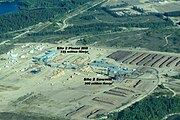 Conifex Site 2 Sawmill, Drying Kilns and Planer
 -
 Newsprint Complex Finlay-Donohue-Abitibi 1989–2007
 -
 St. Peter’s Catholic Church
 -
 Hope Trinity Church
 -
 Living Joy Christian Centre
 -
 Sikh Temple
 -
 Mackenzie (I) Elementary School
 -
 Morfee Elementary School
 -
 Mountain View Elementary School
 -
 Causeway across Parsnip Reach of Williston Lake opened in 2000 to shorten the Log Haul Distance
 -
 Parsnip Bridge completed in 1952 linked Hart Highway to Peace River Country
 -
 Morfee Mountain in Late Afternoon Setting Sun in Winter


References
- ^ "British Columbia Regional Districts, Municipalities, Corporate Name, Date of Incorporation and Postal Address" (XLS). British Columbia Ministry of Communities, Sport and Cultural Development. Archived from the original on 13 July 2014. Retrieved 2 November 2014.
- ^ Conifex Timber web site.
- ^ P&P Canada article on Paper Excellence acquisition of Mackenzie Pulp Operations
- ^ Mount Milligan web site
- ^ Roman Catholic Diocese of Prince George
- ^ Living Joy Christian Centre web site
- ^ "Northern Rockies & Alaska Highway". Destination BC. Retrieved 29 March 2019.
- ^ Atlas of Canada. Lakes Archived 26 April 2006 at the Wayback Machine
- ^ "Calculation Information for 1981 to 2010 Canadian Normals Data". Environment Canada. Archived from the original on 7 February 2014. Retrieved 9 July 2013.
External links
- Mackenzie Chamber of Commerce
- The World's largest tree crusher
- RCMP 'E' Division
- School District 57 (Prince George)
- District of Mackenzie
- Mackenzie Campus of the College of New Caledonia