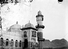
Aidrus Mosque
Appearance
| Aidrus Mosque | |
|---|---|
جامع العيدروس | |
 | |
| Religion | |
| Affiliation | Islam |
| Branch/tradition | Sunni |
| Location | |
| Location | Crater, Aden, Yemen |
| Geographic coordinates | 12°46′21″N 45°02′11″E / 12.7724°N 45.0364°E |
| Architecture | |
| Type | Mosque |
The Mosque of Abu Bakr al-'Aydarus or Aidrus Mosque (Arabic: جامع العيدروس) is a Sufi mosque in Aidrus Street in Crater, Aden Governorate, Yemen. One of the principal mosques in Aden, it is named after Abu Bakr al-Aydarus, the wali of Aden.
Originally built in the late-15th or early-16th century, the mosque underwent rebuilding after being destroyed in 1859. During the 1994 civil war in Yemen, Islamic fundamentalists from North Yemen damaged much of the mosque, burning copies of the Quran and vandalizing tombs in its courtyard.[1]
The mosque is featured on some Aden postage stamps, e.g. the 1938 2 anna stamp.[2]
See also
References
- ^ Daniel McLaughlin (2007). Yemen: The Bradt Travel Guide. Bradt Travel Guides. p. 185. ISBN 978-1-84162-212-5. Retrieved 24 March 2013.
- ^ Stanley Gibbons Ltd. Stanley Gibbons' Simplified Stamp Catalogue; 24th ed., 1959. London: Stanley Gibbons Ltd.' p. 1


