
Bridge Valley Bridge
Bridge Valley Bridge | |
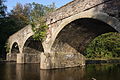
 Bridge Valley Bridge, September 2012 | |
  | |
| Location | Spans Neshaminy Creek north of Hartsville, Hartsville, Pennsylvania |
|---|---|
| Coordinates | 40°16′34″N 75°05′00″W / 40.2762°N 75.0832°W |
| Area | 0.1 acres (0.040 ha) |
| Built | 1804 |
| Built by | Millar, Phillip |
| Architectural style | Other, Neo-Classical Arched Bridge |
| NRHP reference No. | 84003120[1] |
| Added to NRHP | May 10, 1984 |
Bridge Valley Bridge, also known as Pettit's Bridge and Eight-Arch Bridge, is an historic stone arch bridge located in Warwick Township, Bucks County, Pennsylvania, United States. It crosses Neshaminy Creek. It is eight spans, each 27 feet long, and was constructed in 1804. It is constructed of ashlar stone with rubble and dirt infill. It remained in vehicular use until 1970.[2]
It was listed on the National Register of Historic Places in 1984.[1]
Gallery
-
 File:Bridge Valley Bridge closeup, September 2012

References
- ^ a b "National Register Information System". National Register of Historic Places. National Park Service. July 9, 2010.
- ^ "National Historic Landmarks & National Register of Historic Places in Pennsylvania" (Searchable database). ARCH: Pennsylvania's Historic Architecture & Archaeology. Retrieved 2012-10-08. Note: This includes Kathryn Ann Auerbach (November 1983). "National Register of Historic Places Inventory Nomination Form: Bridge Valley Bridge" (PDF). Retrieved 2012-10-08.

This article about a property in Bucks County, Pennsylvania on the National Register of Historic Places is a stub. You can help Wikipedia by expanding it. |
This article about a bridge in Pennsylvania is a stub. You can help Wikipedia by expanding it. |
Categories:
- Road bridges on the National Register of Historic Places in Pennsylvania
- Bridges completed in 1804
- Bridges in Bucks County, Pennsylvania
- Road bridges in Pennsylvania
- National Register of Historic Places in Bucks County, Pennsylvania
- Bucks County, Pennsylvania Registered Historic Place stubs
- Pennsylvania bridge (structure) stubs