Bugungu Airstrip
Bugungu Airstrip | |||||||||||
|---|---|---|---|---|---|---|---|---|---|---|---|
| Summary | |||||||||||
| Airport type | Public | ||||||||||
| Serves | Murchison Falls National Park | ||||||||||
| Elevation AMSL | 2,470 ft / 753 m | ||||||||||
| Coordinates | 2°12′10″N 31°33′16″E / 2.20278°N 31.55444°E | ||||||||||
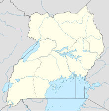
| Map | |||||||||||
 | |||||||||||
| Runways | |||||||||||
| |||||||||||
Bugungu Airstrip is an airport serving the Bugungu Wildlife Reserve in the Murchison Falls National Park (MFNP), in Western Region of Uganda.[1]
Location
[edit]The airstrip is located within Bugungu Wildlife Reserve, in Buliisa District of the Western Region, within the confines of the MFNP.[2]
Bugungu Airstrip is located approximately 260 kilometres (162 mi), by air, and 333 kilometres (207 mi), by road, north-west of Entebbe International Airport, Uganda's largest civilian and military airport.[3]
The geographical coordinates of Bugungu Airstrip are: 02°12'10.0"N, 31°33'16.0"E (Latitude:2.202778; Longitude:31.554444).[4] Bugungu Airstrip is located at an average elevation of 753 metres (2,470 ft), above sea level.[5]
Overview
[edit]Bugungu Airstrip receives daily domestic flights from Entebbe International Airport and Kajjansi Airfield, which are primarily used by tourists to visit Murchison Falls National Park, as well as connecting to Kidepo Valley National Park and Queen Elizabeth National Park.[6]
The airstrip is managed by the Uganda Wildlife Authority, under license by the Uganda Civil Aviation Authority.[7]
Airlines and destinations
[edit]| Airlines | Destinations |
|---|---|
| Aerolink Uganda | Entebbe[8] |
See also
[edit]References
[edit]- ^ Murchison Falls National Park (24 September 2018). "Bugungu Airstrip". Murchison Falls National Park. Retrieved 24 September 2018.
- ^ Wego.Here.Com (24 September 2018). "Satellite Map of Bugungu Airstrip". Wego.Here.Com. Retrieved 24 September 2018.
- ^ Globefeed.com (24 September 2018). "Distance between Entebbe International Airport, 5536 Kampala Road, Entebbe, Uganda and Bugungu Airstrip, Uganda". Globefeed.com. Retrieved 24 September 2018.
- ^ "Location of Bugungu Airstrip, Uganda" (Map). Google Maps. Retrieved 24 September 2018.
- ^ Unipage.net (24 September 2018). "General information about Bugungu Airport". Unipage.net. Retrieved 24 September 2018.
- ^ "Flight Schedule to Murchison Falls National Park". Savannah Wings. Retrieved 1 June 2022.
- ^ Okore, Maurice (23 June 2004). "UWA Takes Over Bugungu Airstrip". New Vision. Kampala. Retrieved 24 September 2018.
- ^ Aerolink Uganda (2019). "Aerolink Uganda Destinations". Entebbe: Aerolink Uganda. Retrieved 17 July 2019.
External links
[edit]

