Calaveras Fault

The Calaveras Fault is a major branch of the San Andreas Fault System that is located in northern California in the San Francisco Bay Area. Activity on the different segments of the fault includes moderate and large earthquakes as well as aseismic creep. The last large event was the magnitude 6.2 1984 Morgan Hill event. The most recent moderate earthquakes were the magnitude 5.1 event on 25 October 2022, and the magnitude 5.6 2007 Alum Rock event.
It is believed to link with the Hayward fault, as well as the West Napa Fault, north of the Carquinez Strait. It passes through or near the cities of Alamo, Danville, San Ramon, Dublin, Pleasanton, Sunol, Milpitas, San Jose, Gilroy, and Hollister.
Location
[edit]
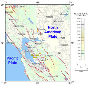
To the east of the Hayward-Rodgers Creek fault, the Calaveras fault extends 123 km (76 mi), splaying from the San Andreas fault near Hollister and terminating at Danville at its northern end.[1] It runs east of the San Andreas, diverging from it in the vicinity of Hollister, California, and is responsible for the formation of the Calaveras Valley there. Between the San Andreas Fault and the Calaveras Fault lies the Hayward Fault, which diverges from the Calaveras Fault east of San Jose, California. To the east lies the Clayton-Marsh Creek-Greenville Fault. These four fault structures are some of the major faults in California at the latitude of San Francisco. All are right lateral-moving strike-slip faults.

The Calaveras Fault was named for Calaveras Creek in Santa Clara County east of San Jose where it was first identified. (Calaveras is Spanish for "skulls".) "Calaveras" is also the name of a California county in the foothills of the Sierra Nevada mountains, some 100 miles (160 km) east of Santa Clara County, far from the Calaveras Fault. Some of the cities which the Calaveras Fault passes through or near are: Alamo, Danville, San Ramon, Dublin, Pleasanton, Sunol, Milpitas, San Jose, Gilroy, and Hollister.
Related faults
[edit]The West Napa Fault in Napa County is believed to be a continuation of the Calaveras Fault north of the Carquinez Strait. Between the faults lies an area of minor faults aligned en echelon known as the Contra Costa Shear Zone.[2]
The minor Concord Fault lies to the east of the Calaveras Fault, and small earthquakes occur in the gap between faults, mostly in the vicinity of Alamo, California, relieving stresses generated by the displacement between the two faults. Stresses are also produced by offset and converging slip-strike motions between the Calaveras and Clayton-Marsh Creek-Greenville Fault that continue to elevate Mount Diablo. The compressive pressure is manifest in a significant thrust fault nearby on the western slope of the mountain, the Mount Diablo Thrust Fault,[3] the most active of its kind in the region and which is also capable of producing significant local earthquakes affecting the Alamo-Danville area.
Tectonic forces
[edit]The Pacific Plate is a major section of the Earth's crust, gradually expanding by the eruption of magma along the East Pacific Rise to the southeast. It is also being subducted far to the northwest into the Aleutian Trench under the North American Plate well north of San Francisco. In California, the plate is sliding northwestward along a transform boundary, the San Andreas Fault, toward the subduction zone. At the same time, the North American Plate is moving southwestward, but relatively southeast along the fault. The westward component of the North American Plate's motion results in some compressive force along the San Andreas and its associated faults such as the Calaveras Fault, thus helping lift the Coast Ranges. The Calaveras Fault shares the same relative motions of the San Andreas.
Seismic activity
[edit]Here are the notable recorded earthquakes on the Calaveras fault: 2022 (5.1), 2007 (5.6), 1984 (6.2) and 1911 (6.5).
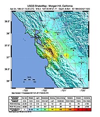
A number of magnitude 6 earthquakes have been recorded on the fault throughout recorded history, the largest of which was a magnitude 6.5 that occurred in 1911 in the Morgan Hill area.[4] The most recent of these was a magnitude 6.2 earthquake near Morgan Hill in 1984.
A magnitude 5.6 earthquake occurred on the Calaveras Fault on October 30, 2007 at 20:04 PDT (October 31, at 03:04 UTC), near Alum Rock. Prior to the 2014 South Napa earthquake, it was the most powerful quake to hit the Bay Area since the Loma Prieta earthquake of 1989, and the largest on the Calaveras Fault since 1984. On October 25, 2022 at 11:42 PDT (October 25, at 18:42 UTC), a magnitude 5.1 earthquake occurred on the fault near Lick Observatory.[5]
Hayward Fault connection
[edit]Although it has been known for some time that the Calaveras and Hayward faults merge in the South Bay region, recent geological studies[6] suggest that the Calaveras and Hayward faults may be even more closely connected horizontally deep beneath the surface, angling toward each other with depth until they become a single fault. If true, this would have significant implications for the potential maximum strength of earthquakes on the Hayward, since this strength is determined by the maximum length of the fault rupture and this rupture could extend beyond the juncture point to include some portion of the Calaveras.
Recent assessment
[edit]Assessments in January 2008 suggest that the northern Calaveras fault (the portion between Sunol and Danville) may be more likely to fail in the next few decades than previously thought.[7]
See also
[edit]References
[edit]- ^ Working Group On California Earthquake Probabilities, "Characterization of the SFBR Earthquake Sources" (PDF), Earthquake Probabilities in the San Francisco Bay Region: 2002–2031, Open-File Report 03-214, United States Geological Survey, p. 16
- ^ http://gsa.confex.com/gsa/2005CD/finalprogram/abstract_85559.htm gsa.confex.com
- ^ https://www.pbs.org/newshour/indepth_coverage/science/1906quake/map6.html PBS
- ^ "Historic Earthquakes: Calaveras fault, California". Archived from the original on 2009-11-10. Retrieved 25 November 2008.
- ^ "M 5.1 - 15km ESE of Alum Rock, CA". USGS. Archived from the original on 2022-10-25. Retrieved 26 October 2022.
- ^ Perlman, David (December 12, 2007). "Hayward, Calaveras faults may be connected, geologist says". San Francisco Chronicle.
- ^ Hayward fault might be more dangerous than scientists thought (San Jose Mercury News)
Further reading
[edit]- Chaussard, E.; Bürgmann, R.; Fattahi, H.; Johnson, C. W.; Nadeau, R.; Taira, T.; Johanson, I. (2015). "Interseismic coupling and refined earthquake potential on the Hayward-Calaveras fault zone" (PDF). Journal of Geophysical Research: Solid Earth. 120 (12): 8570–8590. Bibcode:2015JGRB..120.8570C. doi:10.1002/2015jb012230. ISSN 2169-9313.
- Harris, R. A.; Barall, M.; Lockner, D. A.; Moore, D. E.; Ponce, D. A.; Graymer, R. W.; Funning, G.; Morrow, C. A.; Kyriakopoulos, C.; Eberhart-Phillips, D. (2021). "A Geology and Geodesy Based Model of Dynamic Earthquake Rupture on the Rodgers Creek-Hayward-Calaveras Fault System, California" (PDF). Journal of Geophysical Research: Solid Earth. 126 (3). Bibcode:2021JGRB..12620577H. doi:10.1029/2020jb020577. ISSN 2169-9313.
- McClellan, P. H.; Hay, E. A. (1990). "Triggered slip on the Calaveras Fault during the magnitude 7.1 Loma Prieta, California, Earthquake". Geophysical Research Letters. 17 (8): 1227–1230. Bibcode:1990GeoRL..17.1227M. doi:10.1029/gl017i008p01227. ISSN 0094-8276.
External links
[edit]- Seismic faults of California
- Strike-slip faults
- Geology of Contra Costa County, California
- Geology of San Benito County, California
- Geology of Santa Clara County, California
- Diablo Range
- Danville, California
- San Ramon, California
- Dublin, California
- Geography of Pleasanton, California
- Milpitas, California
- Geography of San Jose, California
- Gilroy, California
- Hollister, California
- Geography of the San Francisco Bay Area


